
Caminos de la Villa: Mapping the Invisible for the Right to the City
The role of Participatory Social Mapping in the struggle of the territory and the right to the city: A case study in Buenos Aires Case Study
This paper presents "Caminos de la Villa," a case study of participatory social mapping in the informal settlements (villas) of Buenos Aires. By leveraging collaborative cartography and GIS tools, the project successfully mapped "invisible" territories to empower residents and advocate for the "Right to the City."
TL;DR
In the sprawling "villas" of Buenos Aires, being off the map means being outside the law. This case study explores how Caminos de la Villa, a participatory mapping project, transformed "empty" urban spaces into recognized neighborhoods. By combining digital GIS tools with grassroots activism, the project empowered marginalized communities to demand infrastructure, visibility, and their fundamental "Right to the City."
The Problem: The Violence of Invisibility
For over 200,000 inhabitants of Buenos Aires' informal settlements, the city's official maps were a form of erasure. These neighborhoods were often depicted as solid grey blocks without internal streets or addresses.
The consequences were practical and severe:
- Service Failure: Residents could not use official government apps (like BA147) to report broken pipes or power outages because their locations "did not exist."
- Emergency Access: Ambulances and police frequently refused to enter "unmapped" zones due to fear of the unknown.
- Stigmatization: As Pierre Bourdieu noted, referring to "ghettos" creates phantasms rather than realities. Maps without detail reinforce the idea of these areas as lawless, cohesive "others" rather than vibrant urban fabrics.
Methodology: Mapping as Social Practice
The project was led by NGOs ACIJ and Wingu, but its soul was participatory. The methodology moved beyond mere data collection into Social Mapping, which views the creation of a map as a social construction of place.
The Workflow
- Workshops: Residents and students used paper and digital tools to identify internal roads, schools, and community centers.
- Point of Interest (POI) Identification: Moving beyond physical infrastructure to map "locale" and "sense of place."
- Platform Integration: A user-friendly application allowed citizens to monitor public works and file claims.
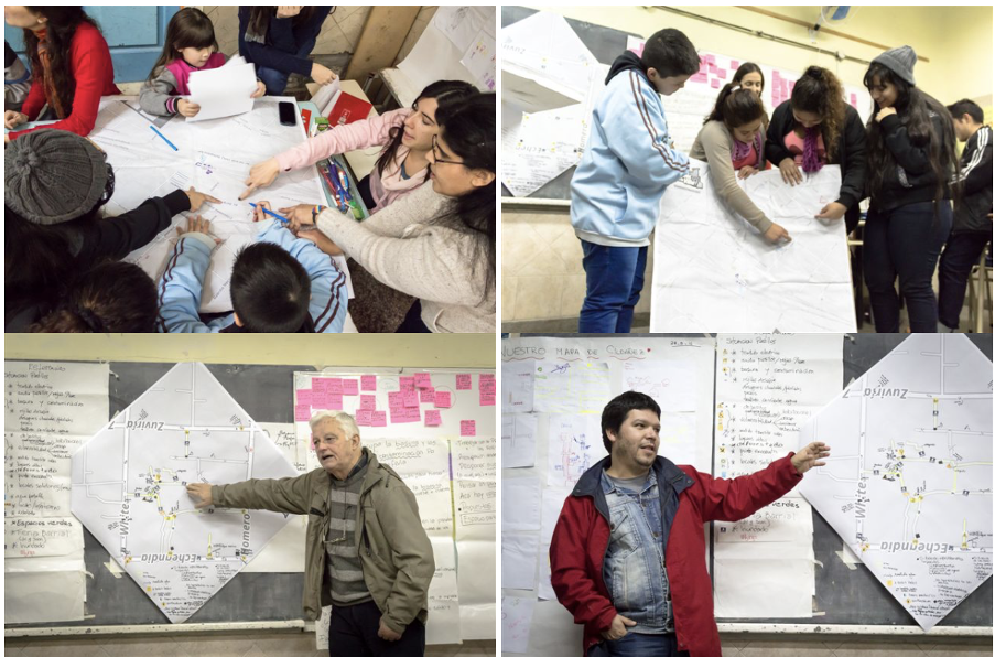 Figure 1: Residents and activists engaging in the collaborative mapping process to define their own territory.
Key Findings: The Duality of Active Maps
The research highlights that maps are not neutral reflections of reality but active discursive practices.
1. Empowerment through Self-Representation
The project achieved a massive win when the Government of the City of Buenos Aires (GCBA) was forced to adopt the NGO’s maps. For the first time, "Villa 21-24" or "Zavaleta" had streets and blocks on official digital layers. This wasn't just a technical update; it was a recognition of citizenship.
2. Low-Tech Appropriation
A fascinating finding was the residents' use of "low-tech" solutions. When digital barriers (lack of internet or technical skills) arose, neighbors printed the maps and carried them physically to government offices to demand rights. This proves that the symbolic appropriation of the information was more important than the digital platform itself.
Challenges and Critical Analysis
Despite its success, the study identifies two major hurdles:
- Technical Dependency: Reaching high levels of "hacking skills" (as defined by Haklay’s levels of appropriation) is difficult for non-experts. The project relied heavily on the technical backbone provided by NGOs.
- Engagement Decay: In informal settlements, daily survival often takes priority over digital reporting. Without constant face-to-face presence and visible, immediate results, user engagement naturally drops.
Conclusion: One Step Closer to Emancipation
While the "Caminos de la Villa" project did not fully replace traditional negotiation methods, it provided the infrastructure of visibility. It allowed invisible communities to speak for themselves and systematize local knowledge.
The ultimate takeaway is that participatory GIS is most effective when it is embedded in a broader political struggle for the Right to the City—treating the map not as a finished product, but as a weapon for social change.
Disclaimer: This analysis is based on Portela and Errandonea (2017), "The role of Participatory Social Mapping in the struggle of the territory and the right to the city."