
Smart-Patrolling: Scaling Road Surface Monitoring via DTW and Crowdsourcing
Pervasive and mobile computing
This paper introduces Smart-Patrolling, a crowdsourcing-based system for road surface anomaly detection (potholes and bumps) using smartphone accelerometers and GPS. It leverages Dynamic Time Warping (DTW) to achieve high classification accuracy across varying vehicle speeds and device types without intensive training.
TL;DR
Maintaining urban road infrastructure is a logistics nightmare. Smart-Patrolling is a research-backed solution that turns every commuter's smartphone into a sophisticated road quality inspector. By using Dynamic Time Warping (DTW) instead of traditional machine learning, the system identifies potholes and bumps with ~89% accuracy, regardless of how fast you drive or what phone you use.
Context & Positioning
In the landscape of Intelligent Transportation Systems (ITS), we've moved from manual "pavement management" to automated sensing. However, early automated systems like Pothole Patrol required dedicated hardware, and newer smartphone-based apps often fail due to the heterogeneity problem: different cars, speeds, and mounting positions make "threshold-based" detection unreliable. This paper positions itself as a robust, training-light alternative to heavy ML models (like SVM or ANN) by focusing on signal shape similarity rather than raw magnitude.
The Core Problem: Why Most Apps Fail
Most existing solutions struggle with three variables:
- Velocity Indeterminacy: A pothole hit at 20 km/h creates a different signal stretching than at 60 km/h.
- Orientation Noise: Phones are rarely perfectly flat; they are in pockets, dashboards, or mounts.
- Training Fatigue: ML models require thousands of labeled examples for every new city or vehicle type.
Methodology: The "Smart-Patrolling" Pipeline
The authors solve these issues through a methodical signal processing chain:
1. Virtual Re-orientation
Using Euler's Angles, the system mathematically rotates the 3-axis accelerometer data back to a global frame. This ensures that the vertical "Z-axis" impacts are isolated, regardless of how the phone is tilted.
2. The Power of DTW (Dynamic Time Warping)
This is the secret sauce. Unlike Euclidean distance, which compares points at , DTW "warps" the time axis. If a reference pothole signal is 0.5 seconds long and the live signal is 0.8 seconds (due to lower speed), DTW finds the "optimal alignment path" to recognize the pattern anyway.
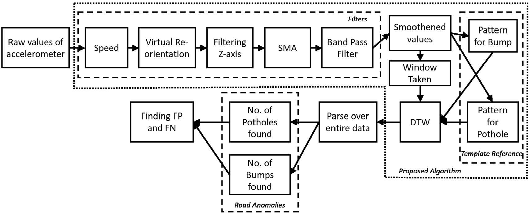 Figure 1: The Smart-Patrolling detection mechanism showing the flow from raw sensor data to DTW analysis.
3. Template Matching
Instead of training a model on millions of points, the authors use high-quality Template References—distilled "signatures" of a typical bump or pothole.
Experiments and Results
The study was conducted in Chandigarh, India, covering 220 km per day. They tested across six different smartphone models placed in various cabin positions.
- Pothole Detection Rate: 88.66%
- Bump Detection Rate: 88.89%
Comparatively, the Wolverine system (SVM-based) and Nericell (Threshold-based) showed significantly higher False Negative (FN) rates, particularly because they couldn't adapt to the time-warped nature of variable-speed hits.
 Table 1: Smart-Patrolling vs. Existing SOTA methods.
Visual Evidence: Crowdsourced Heatmaps
The ultimate value of this work is the aggregation of data. Over 4 weeks, the system generated heatmaps that clearly showed which road patches (labeled V1 and V2) were deteriorating and—more importantly—when they were eventually repaired by the city.
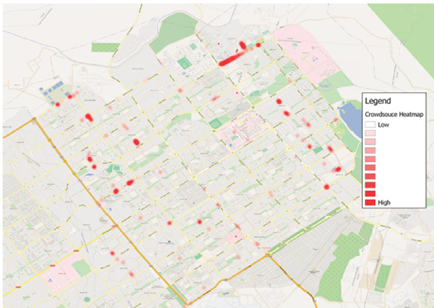 Figure 2: Heatmap visualization over 4 weeks showing pothole clusters and repair trends.
Critical Insight: The "Backseat" Limitation
An interesting finding was the impact of phone placement. The Moto E phone placed in the backseat had a much lower detection rate. Why? The car's suspension and seat cushioning acted as a physical "Low-Pass Filter," absorbing the sharp high-frequency impulses of the road anomalies. This suggests that for crowdsourcing to be effective, systems must "weight" data based on cabin location or sensor sensitivity.
Conclusion
Smart-Patrolling moves away from the "black box" of heavy machine learning and returns to elegant signal processing. By leveraging DTW, the authors achieved SOTA results on resource-constrained devices, proving that for certain IoT tasks, mathematical intuition beats data-heavy training.
Future Outlook: Integrating this with computer vision (front-facing cameras) could create a multi-modal "pothole ground truth" that would be virtually perfect.