
Smart-Patrolling: Redefining Road Monitoring via DTW and Crowdsourcing
Pervasive and mobile computing
The paper introduces Smart-Patrolling, a crowdsourcing-based road monitoring system that utilizes smartphone accelerometers and GPS to detect potholes and bumps. It leverages Dynamic Time Warping (DTW) to achieve high detection accuracy (88.66% for potholes, 88.89% for bumps) across varying vehicle speeds and device types.
TL;DR
Maintaining safe road infrastructure is a massive logistical challenge for cities. Smart-Patrolling shifts the burden from expensive manual inspections to the pockets of everyday commuters. By applying Dynamic Time Warping (DTW) to smartphone accelerometer data, this system identifies potholes and bumps with ~89% accuracy, remaining resilient to different driving speeds and vehicle types without the need for massive "big data" training.
The Problem: The "Threshold" Trap vs. The "ML" Burden
Most existing intelligent transportation research falls into two camps:
- Fixed Thresholds: They assume if the Z-axis acceleration hits a certain "G" force, it's a pothole. However, a pothole hit at 20 km/h looks very different from one hit at 60 km/h.
- Machine Learning (SVM/ANN): While accurate, these models are "data-hungry." To work reliably, they need to be trained on specific car suspensions and road types, making them hard to scale globally.
Smart-Patrolling identifies a middle ground: Dynamic Time Warping.
Methodology: The Core Engine
The beauty of the Smart-Patrolling system lies in its ability to handle temporal deformations. If a car slows down while hitting a bump, the "signature" of that bump stretches in time. DTW excels here by finding the "optimal alignment" between a reference template and the live signal.
The Processing Pipeline:
- Virtual Re-orientation: Users don't hold phones perfectly flat. The system uses Euler angles (Roll, Pitch, Yaw) to re-align any arbitrary phone orientation to the vehicle's true vertical axis.
- Filtering & Noise Reduction: Using a combination of Simple Moving Average (SMA) and Band-Pass Filters (BPF), the system strips away high-frequency engine vibrations and low-frequency gravity shifts.
- DTW Pattern Matching: Instead of a fixed number, the system looks for the shape of the vibration.
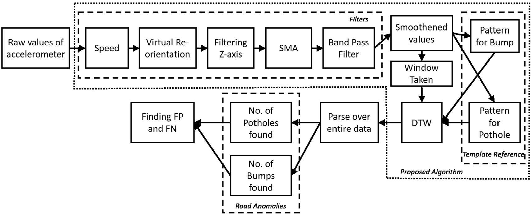 Figure 1: The holistic workflow from raw sensor data to thermal map visualization.
Experiments & Real-World Impact
The authors tested the system in Chandigarh, India, using six different smartphone models (ranging from high-end Nexus 5 to entry-level Moto E).
Key Findings:
- Scale of Success: While previous baselines like Nericell struggled with high false-negative rates, Smart-Patrolling maintained an 88.66% detection rate.
- Hardware Agnostic: High-end phones (Samsung Note 3) performed slightly better due to sensor sensitivity, but the DTW approach allowed even budget phones to contribute meaningful data.
- Maintenance Tracking: By visualizing data over four weeks, the authors could actually see when civic authorities repaired specific "Area 1" or "Area 2" potholes.
 Table 1: Smart-Patrolling vs. Traditional Baselines (Note the dramatic leap in detection rate).
Critical Insight: Why DTW?
The technical intuition here is that road anomalies are signatures, not just spikes. A pothole has a distinct "drop-then-impact" pattern. A fixed threshold only catches the "impact," but DTW catches the "story" of the event. Furthermore, DTW’s complexity is manageable for the short 5-point windows used here, making it perfect for real-time edge processing on a smartphone.
Conclusion & Future Look
Smart-Patrolling proves that we don't always need "Black Box" Deep Learning for complex signal tasks. By using a robust mathematical comparison tool like DTW and the power of crowdsourced data, city authorities can transition from reactive repairs to proactive infrastructure management.
Future Step: Integrating this with "Active Suspension" systems in EVs could allow cars to not only report potholes but also adjust their damping in milliseconds to protect the passengers.