
Intelligent Photo Crowdsourcing: Optimizing Area Coverage via Geometric Metadata
Photo crowdsourcing for area coverage in resource constrained environments
This paper introduces a metadata-based photo crowdsourcing framework designed to maximize area coverage in resource-constrained environments like disaster recovery. It proposes an "Area Aspect Coverage" model and a "Budgeted Max-Utility" selection algorithm to optimize photo collection without intensive image processing.
TL;DR
When disaster strikes, we need onsite photos fast. However, uploading thousands of high-res images quickly chokes limited bandwidth. This paper proposes a system that selects the "best" photos based solely on metadata (where the camera is pointed), ensuring maximum area coverage and multi-angle views while staying within a strict resource budget.
Motivation: The Blind Spots of Current Crowdsourcing
In scenarios like disaster recovery or building street-view maps for campuses, two major bottlenecks exist:
- Resource Scarcity: Bandwidth, storage, and CPU cycles are too limited to process or upload every photo taken by participants.
- Angle Matters: Just knowing a photo was taken at a certain GPS coordinate isn't enough. If the camera was facing a wall instead of the fire, the photo is useless.
The authors argue that we must consider Aspect Coverage: a point is only truly "covered" if we have photos of its different sides (front, side, back).
Methodology: From Metadata to Utility
The core innovation lies in treating photo coverage as a geometric problem rather than an image processing one.
1. The Aspect Model
The system uses four parameters: Location (), Orientation (), Field of View (), and Range (). A point's "Utility" is defined by how many of its 360-degree aspects are covered by the available photos.
2. Geometric Partitioning
To calculate utility over an entire area (which has infinite points), the authors developed a three-step spatial partition:
- Coverage Area Partition: Dividing the map based on which photos overlap a region.
- Photo Line Partition: Ordering cameras relative to a region.
- Critical Arc Partition: Using the "Critical Arc" (where the angle between two cameras is exactly ) to determine if their coverage overlaps or bridges a gap.
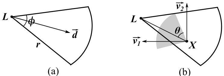 Fig 1. Illustration of how the sector model and aspect coverage (Effective Angle ) define photo utility.
3. The Budgeted Selection Algorithm
The problem of picking the best subset of photos under a budget (e.g., total MBs) is NP-hard. The authors proposed a dual-greedy approach:
- Cost-Aware: Picks photos based on marginal utility per unit cost.
- Cost-Ignored: Picks photos strictly based on marginal utility.
- Result: By taking the better of the two, they achieve a 0.32 approximation ratio—a proven performance guarantee even in worst-case scenarios.
Experimental Validation
The team tested the system in a real-world townhouse community using Android devices.
Performance vs. Baselines
Compared to random selection or simple location-based filtering, their algorithm significantly outperformed in "Entrance Coverage"—a proxy for how much useful semantic information was actually captured.
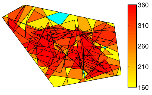 Fig 2. Heat maps comparing (a) the proposed algorithm vs (b, c) baselines. Red areas indicate high-density, multi-angle coverage.
Key Findings:
- Efficiency: Uploading only 19% of the data captured 96% of the possible utility.
- Accuracy: Their mathematical partitioning was far more precise than standard "grid sampling" methods, which often miss small coverage gaps.
- Scalability: The simulation showed a clear "diminishing returns" point ( photos), helping organizers decide when they have enough data to stop crowdsourcing.
Critical Insight & Future Outlook
While the paper masterfully handles the geometry of coverage, it acknowledges a major hurdle: Occlusion. A building might be in the camera's line of sight on a map, but a tree or truck could be blocking the actual view.
The authors suggest that their "multi-angle" utility metric naturally mitigates this—if you photograph a point from 5 different directions, the odds that all are occluded is low. Future iterations incorporating 3D map data (like building heights) could make this metadata-only approach nearly as accurate as full CV analysis at a fraction of the cost.
Conclusion
This work shifts the focus of crowdsourcing from "collecting everything" to "collecting smartly." By leveraging the sensors already in our pockets, we can build efficient digital eyes for emergency responders and mapmakers alike.