
Geo-Homophily: Decoding Human Migration through the Lens of Online Social Networks
Population Distribution Projection by Modeling Geo Homophily in Online Social Networks
The paper introduces a Bayesian nonparametric framework to project population distributions and floating populations by analyzing "Geo-homophily" in Online Social Networks (OSNs). By leveraging WeChat and Gowalla datasets, the authors achieve a high correlation (0.8) with national census data using a specialized Floating Population Inference Model (FPIM).
TL;DR
Researchers from Peking University have developed a framework that predicts where people live and how they migrate by analyzing who they talk to online. By modeling Geo-homophily—the spatial bias in our digital interactions—and using Dirichlet Processes, they achieved an 80% correlation with real-world national census data, turning social media metadata into a real-time demographic sensor.
Background: The Digital Mirror of Physical Space
Conventionally, understanding population flow requires heavy lifting: analyzing bank notes, mobile roaming data, or waiting years for a national census. This paper posits that we don't need to track every step a person takes if we can see their social circle. The core insight is that our "digital neighbors" are often our "physical neighbors." This link is called Geo-homophily.
Problem & Motivation: Why is this hard?
While it's intuitive that people in Beijing talk to other people in Beijing, the data is noisy.
- Symmetry Issues: Online relationships don't always reflect current physical locations (e.g., a migrant worker in Shanghai still talks to family in Sichuan).
- Scale: Processing billions of retweets to find a stable signal of "population distribution" is a massive computational and statistical challenge.
The authors suggest that instead of just looking at where a user is, we should look at the stability of message diffusion patterns over time.
Methodology: The Three-Layer Framework
The paper introduces a structured approach to bridge the gap between a "retweet" and a "resident."
1. The Concept of Geo-homophily
The authors adapt the concept of Modularity () to measure how "geographic" a network is. If is high, users are clustered within regions. If is near zero, the network is geographically random.
2. Dirichlet Process Mixture (DPM)
To handle the "User Distribution Model" (UDM), they use a Dirichlet Process. Imagine a "Chinese Restaurant Process": a new OSN user joins a "table" (region) based on how many of their friends are already sitting there. This allows the model to predict population density without needing explicit GPS coordinates for every single user.
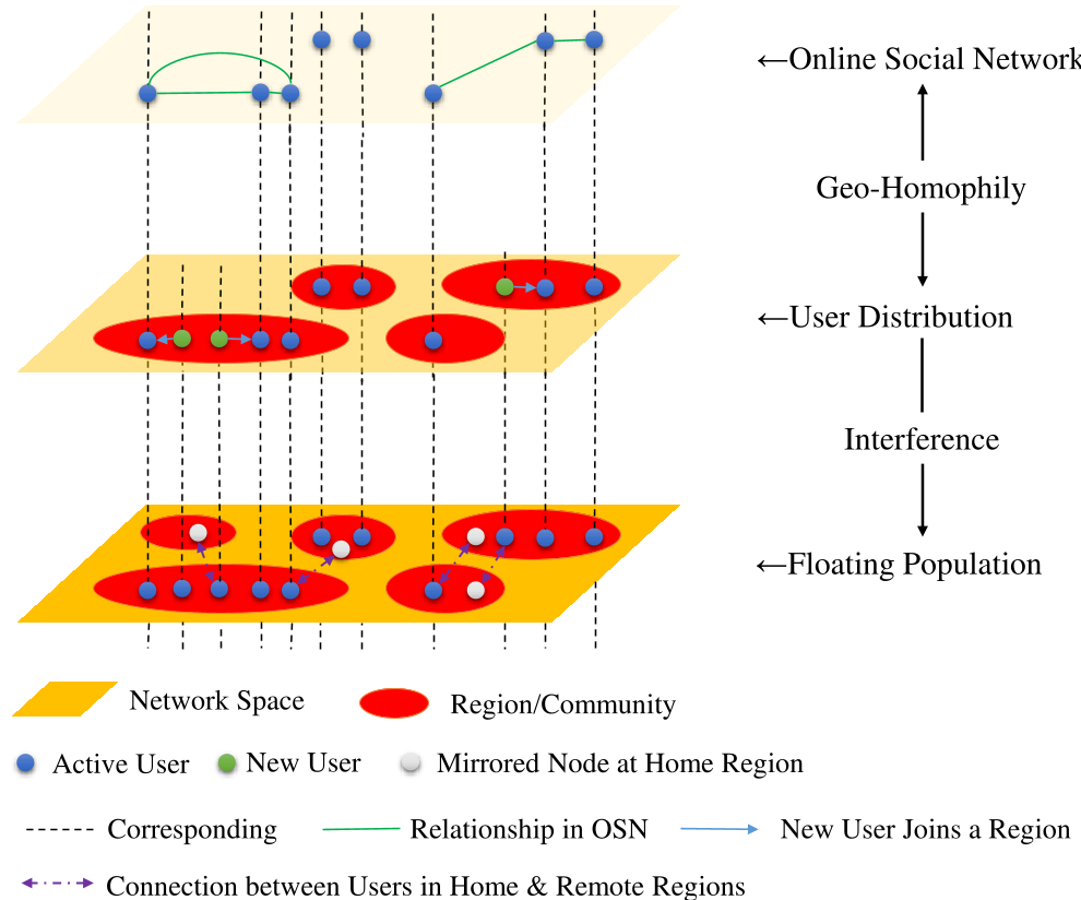
3. State Difference & Floating Population (FPIM)
The most brilliant part of the methodology is the Floating Population Inference Model (FPIM). By comparing the "Baseline State" (Lunar New Year, when everyone is at their home region) with the "Working State" (typical business days), they can isolate the "State Difference" (). This mathematical subtraction cancels out the background noise, leaving a clear signal of who is a "migrant" and who is a "local."
Experiments: Validating with WeChat & Gowalla
The researchers tested their model on the WeChat Moments dataset, which captured 1.6 billion interactions during the 2016 Spring Festival—one of the largest human migrations on Earth.
- Modularity Peak: They found that during the holiday, modularity increased from 0.49 to 0.53, proving that the network becomes more "geographically organized" when people return to their hometowns.
- Accuracy: The correlation between their predicted floating population and the official 2010 China Census reached 0.8, a remarkable feat for a "lightweight" digital model.
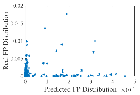 The figure above demonstrates the high correlation (0.8) between the FPIM prediction and actual census data once the State Difference is applied.
Deep Insights & Conclusion
This work highlights a shift in social sensing. We are no longer just looking at content (what people say) but at the topology of the network relative to physical boundaries.
Takeaways:
- The Baseline Matters: Simply looking at message counts is a poor predictor ( correlation). You must account for the "State Difference" (the delta between work and home periods).
- Scale and Privacy: This method is privacy-preserving as it works on aggregated regional distributions rather than individual tracking.
Limitations: The model slightly underestimates population counts because not every migrant uses WeChat (the "Digital Divide"). Future work could integrate multiple OSN sources to bridge this gap.
Final Thought: As cities become "smarter," the ability to project population shifts using existing digital infrastructure—without deploying new hardware—will be the cornerstone of future urban governance.