
High-Frequency Wildfire Risk: Predicting 1-Hour Dead Fuel Moisture via Himawari-8
Predicting 1-H Dead Fuel Moisture Content at Regional Scales Using Machine Learning from Himawari-8 Data
This study proposes a machine learning-based framework to predict 1-hour Dead Fuel Moisture Content (DFMC) at regional scales using geostationary Himawari-8 satellite data. By leveraging Random Forest and Recursive Feature Elimination (RFE), the research achieves a superior prediction performance (R2=0.53, RMSE=3.15%) compared to traditional linear models.
TL;DR
Wildfire ignition is often a race against time, where the moisture levels of fine "1-hour" fuels (twigs and leaf litter) change by the minute. This research introduces a machine learning approach using Himawari-8 geostationary satellite data to predict Dead Fuel Moisture Content (DFMC) every 10 minutes at a 2km resolution, achieving a significant performance leap over traditional linear methods (R² 0.53 vs 0.21).
Background & Motivation: The Challenge of the "1-Hour" Window
In the context of forest fires, not all fuel is created equal. 1-hour dead fuels (diameter < 0.635 cm) are the primary drivers of fire ignition because they respond almost instantly to atmospheric changes.
Current estimation methods face a "Blind Spot Duo":
- Spatial Blind Spot: Meteorological stations are too sparse to account for complex terrain.
- Temporal Blind Spot: Polar-orbiting satellites (like MODIS) only pass over 1-2 times a day, missing the rapid diurnal swings in moisture that occur between sunrise and sunset.
The authors argue that the Himawari-8 satellite, with its 10-minute full-disk observation frequency, is the "missing link" for monitoring these fast-moving variables.
Methodology: From Raw Pixels to Moisture Insight
The study treats DFMC prediction as a high-dimensional regression problem. The workflow involves three critical stages:
1. Ground Truth Collection
Field surveys were conducted in Liangshan, China, collecting 41 sampling plots. Samples were weighed, dried for 24 hours at 105°C, and matched precisely with Himawari-8 observation timestamps.
2. Feature Engineering & Selection
The authors started with 24 potential predictors, including 16 multispectral bands and various vegetation indices. To avoid the "Curse of Dimensionality," they used Recursive Feature Elimination (RFE).
Surprisingly, the optimal subset (7 variables) emphasized geometric factors (Solar/Satellite Zenith and Azimuth angles) and modified indices like SAVI (Soil-Adjusted Vegetation Index) over raw spectral data. This suggests that the relationship between reflectance and moisture is heavily influenced by the angle of observation and soil background interference.
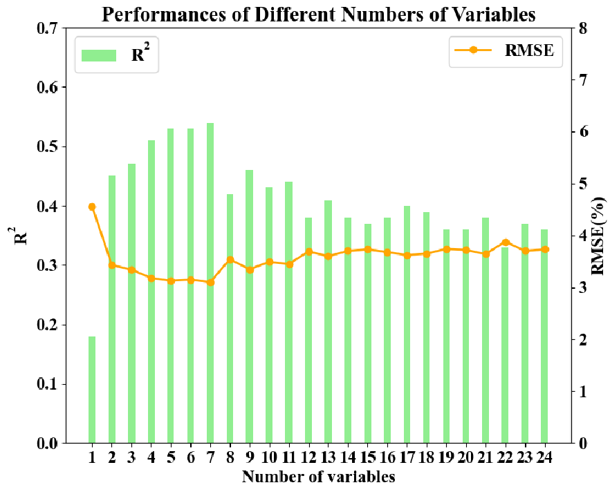 Fig 2: Optimization of R² and RMSE through increasing the number of variables.
3. Random Forest vs. Linear Regression
The team utilized a Random Forest (RF) ensemble. Unlike linear models, RF can capture the non-linear "Vapor-Precipitation-Radiation" interactions that govern fuel drying without needing an explicit physical formula for every variable.
Results: A New Benchmark for Accuracy
The experimental results validate the shift toward non-linear machine learning:
- Random Forest: R² = 0.53 | RMSE = 3.15%
- Linear Regression: R² = 0.21 | RMSE = 5.47%
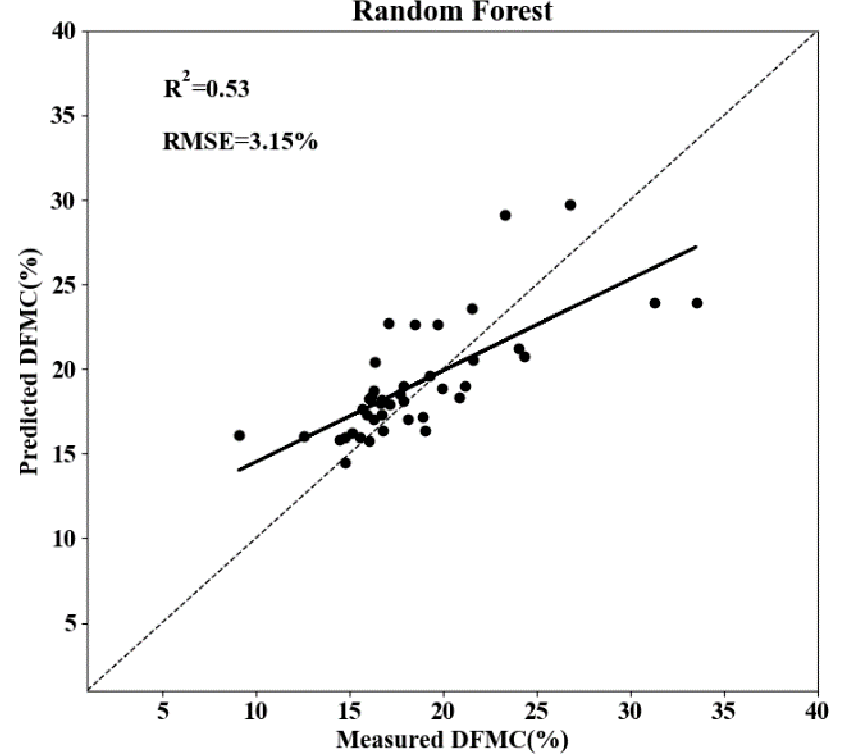 Fig 3: Predicted vs. Measured FMC using the Random Forest model shows a strong alignment along the 1:1 line.
The Random Forest model effectively "learned" the moisture patterns that linear models found chaotic, particularly in the lower moisture ranges (below 15%) where fire risk is most acute.
Critical Analysis & Future Outlook
Takeaways
- Geostationary is King for Fine Fuels: For variables that change hourly (like 1-h DFMC), temporal resolution is just as important as spatial resolution.
- Context Matters: The high ranking of Zenith/Azimuth angles in feature importance proves that "sun-sensor" geometry is vital for correcting reflectance data in rugged forest regions.
Limitations & Complexity
While the R² of 0.53 is a massive improvement over linear baselines, it still leaves room for enhancement. The model's performance may be limited by:
- Canopy Interference: Satellites see the top of the canopy, while 1-hour dead fuel often sits on the forest floor.
- Dataset Size: 41 sampling plots is a small "N" for complex machine learning; expanding the temporal and spatial span of ground truth data would likely boost robustness.
The Path Ahead
Integrating this 10-minute DFMC data into Active Fire Spread Simulators could transform how firefighters allocate resources during a live blaze. The next frontier likely involves combining this satellite-derived data with State Space Models (SSM) or LSTM networks to predict fuel moisture hours into the future.