
From Climate to Canvas: Generative AI Predicts Landscapes from Environmental "Blueprints"
PREDICTING LANDSCAPES FROM ENVIRONMENTAL CONDITIONS USING GENERATIVE NETWORKS A PREPRINT
The paper proposes a novel framework for predicting multispectral landscape imagery (Sentinel-2) from environmental drivers using Conditional Generative Adversarial Networks (cGANs). By mapping 32 predictors covering climate, topography, and human intervention, the model successfully generates photointerpretable 2D aerial views that outperform traditional regression baselines in structural and compositional fidelity.
Executive Summary
TL;DR
Can we look at a map of climate and terrain and "imagine" exactly how that landscape looks from space? This paper introduces a breakthrough approach using Conditional Generative Adversarial Networks (cGANs) to transform 32 environmental variables—such as precipitation, lithology, and human impact—into 4-band multispectral Sentinel-2 imagery. The result is a model that doesn't just predict pixel values but synthesizes ecologically meaningful landscape structures.
Background Positioning
While satellite imagery has long been used to classify the Earth, this work flips the script: it predicts the imagery itself. It sits at the intersection of Computer Vision (Image-to-Image translation) and Earth System Science, moving beyond simple regression toward a "statistical simulator" of the Earth's surface.
Problem & Motivation: The Complexity of the Mosaic
Landscapes are the physical manifestation of long-term abiotic and biotic interactions. In ecology, the relationship is often simplified to . However, numerically simulating this "function" is an impossible task for traditional mechanistic models due to the chaotic nature of biological succession and human activity.
The authors' core Insight: We may not need to solve the physics of every tree and rock if we can learn the statistical distribution of what looks like given its forming factors. Prior work failed because it ignored spatial context (neighboring pixels) and structural realism, leading to "blurry" or structurally incoherent predictions.
Methodology: Mapping the Environment to Pixels
The researchers utilized a dataset covering 10% of the Earth's emerged surface, matching Sentinel-2 imagery with WorldClim, SRTM (altitude), and GLiM (lithology) data.
The Architecture
The core engine is a Pix2Pix-style cGAN. Unlike a standard neural network that minimizes Mean Squared Error (MSE)—which often leads to blurry images—the cGAN uses a Discriminator that forces the Generator to produce "sharp" features that look indistinguishable from real satellite patches.
Note: The architecture relies on a U-Net backbone where skip-connections ensure that if a predictor indicates a steep slope at coordinate (x,y), the generated image places the corresponding terrain feature at that exact location.
Expert Evaluation via Patch Metrics
To move beyond "looking good," the authors used Fragstats to calculate landscape level patch metrics (e.g., Connectance, Mesh Size). This allowed them to prove that the generated landscapes weren't just pretty pictures, but shared the same mathematical spatial organization as real ecosystems.
Experiments & Results: Realism vs. Extrapolation
SOTA Comparison
In "Experiment One," the GAN models significantly outperformed Fully Connected (FC) baselines. The FC models produced correct average colors but zero texture. The GANs, however, successfully "hallucinated" agricultural field boundaries and forest fringes.
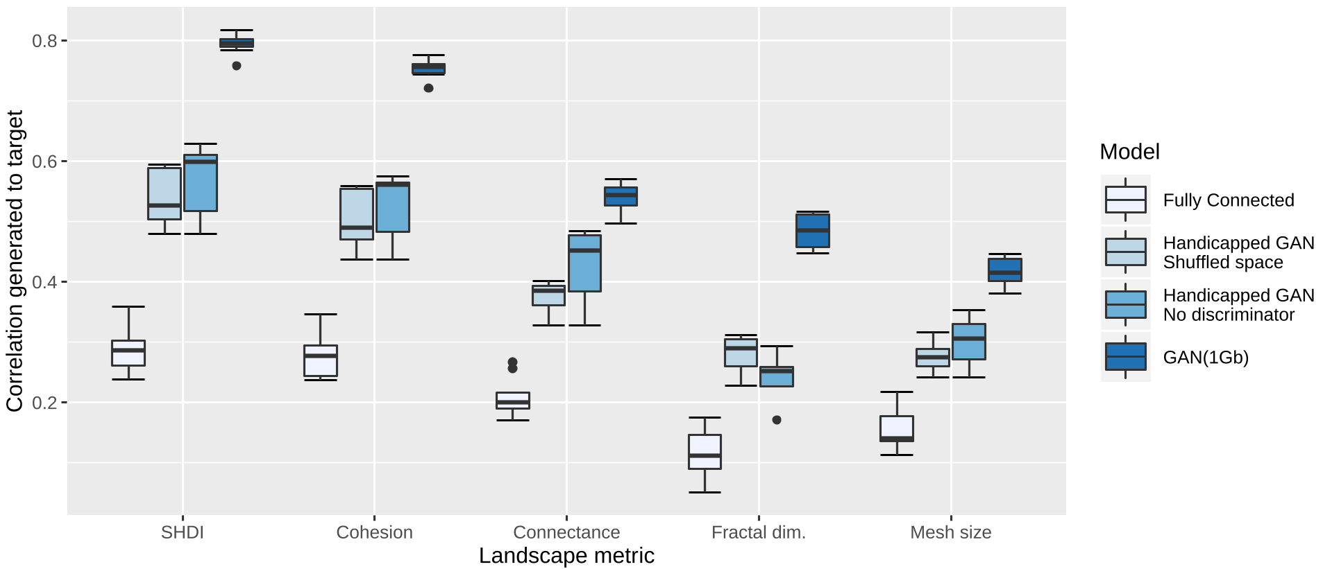 Figure 1: Comparison of landscape metric correlations between real and generated data. Note the significant lead of GAN 1GB over the FC baseline.
The "Intercontinental" Challenge
One of the most impressive feats was spatially independent testing. Even when trained on one continent and tested on another (e.g., predicting the Americas from European/African data), the GAN models maintained high structural fidelity, though they did suffer from some performance decay due to "domain shift" in lithology and climate combinations.
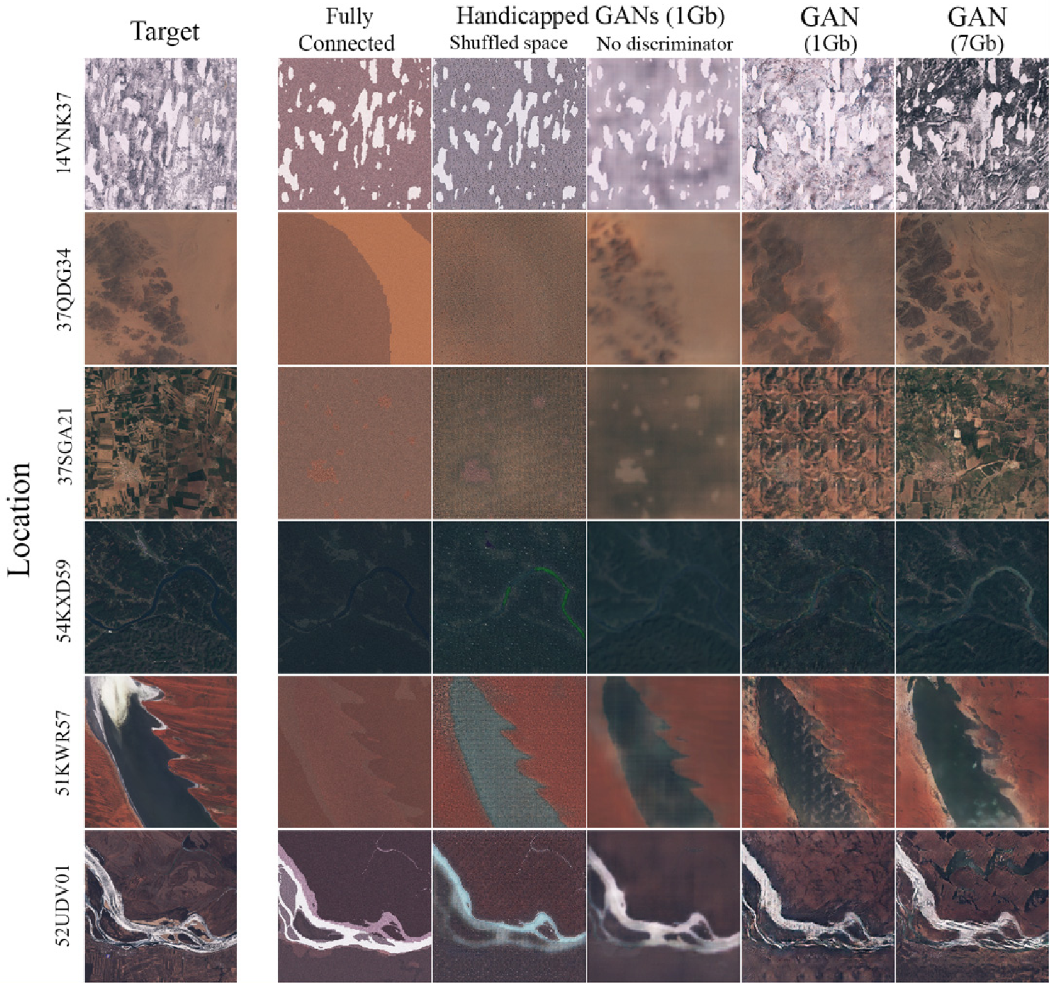 Figure 2: Visual results showing how GAN models (far right) produce much crisper, photointerpretable textures compared to the blurry "No Discriminator" or noisy "FC" models.
Critical Analysis & Conclusion
Takeaway
The study proves that the statistical link between environmental "forming factors" and the visual appearance of a landscape is strong enough to be captured by deep learning. This creates a "digital twin" capability for Earth observation.
Limitations & Future Work
- Space-for-Time Assumption: The model assumes a steady state. If you change the climate inputs to represent 2050, the model shows you what a 2050 climate would look like today if it had already reached equilibrium. In reality, ecosystems have "inertia"—forests take decades to die or grow.
- Mode Collapse: The current GAN setup struggle to show uncertainty. There isn't just one possible landscape for a given climate, but a range of them. Future iterations using Probabilistic Latent Spaces or Diffusion Models could address this.
Impact
By allowing researchers to "visualize" hypothetical climate scenarios, this work bridges the gap between abstract climate data and human perception, making the impacts of global change visceral and understandable.