
Towards Holistic Plant Protection: A FANET and WSN Integrated Architecture
Towards Protecting Agriculture from Exogenous and Endogenous Factors: An Holistic Architecture
This paper proposes an integrated smart farming architecture that combines Wireless Sensor Networks (WSN) and Flying Ad-hoc Networks (FANETs) to protect crops from pests and diseases. The system leverages multispectral UAV imaging and real-time ground sensor data, processed via Machine Learning and Computer Vision in a cloud environment.
TL;DR
To combat global crop losses that threaten food security for a growing population, this paper presents a hybrid smart farming architecture. By combining ground-based Wireless Sensor Networks (WSN) for micro-climate monitoring and Flying Ad-hoc Networks (FANETs) for rapid aerial multispectral scanning, the system enables early detection of pests and diseases, potentially reducing data collection time by 75%.
The Growing Threat to Global Food Security
Pathogens and pests are currently responsible for devastating losses in primary crops, including up to 41% of rice and 32% of soybean yields. As the global population trends toward 9 billion by 2050, the inefficiency of traditional "blanket" chemical application and reactive monitoring is no longer sustainable. The core challenge lies in the early detection of anomalies—often invisible to the naked eye—across thousands of acres of farmland.
Methodology: The Holistic Sensing Stack
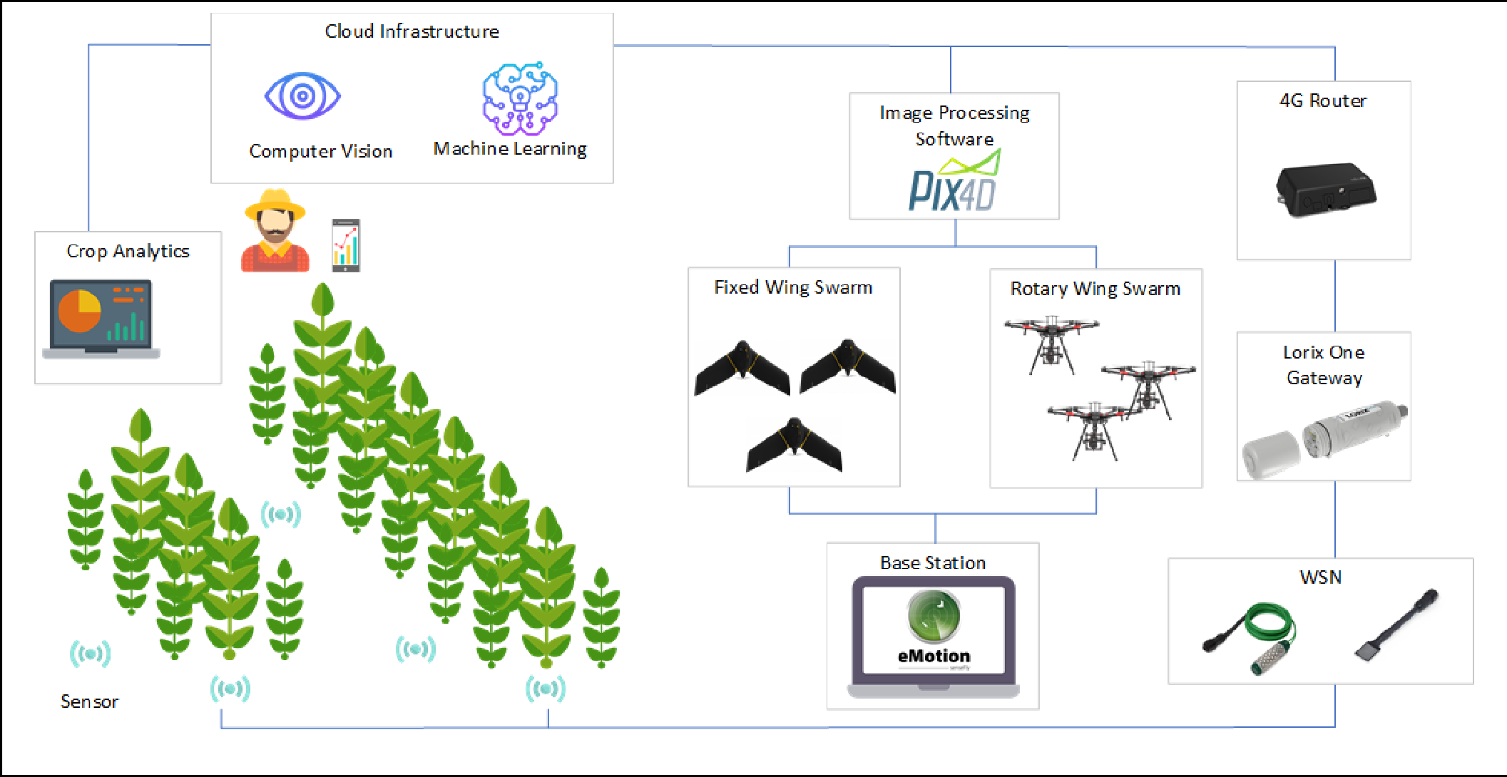
The authors propose a multi-tier architecture that bridges the gap between ground-level physiological data and high-altitude spectral analysis.
1. Ground Layer: LoRaWAN-enabled WSN
Low-power sensors are deployed to monitor soil moisture, pH, leaf moisture, and atmospheric conditions. Data is transmitted via the LoRaWAN protocol to a gateway (Lorix One), ensuring long-range connectivity even in remote rural areas.
2. Aerial Layer: The FANET Leap
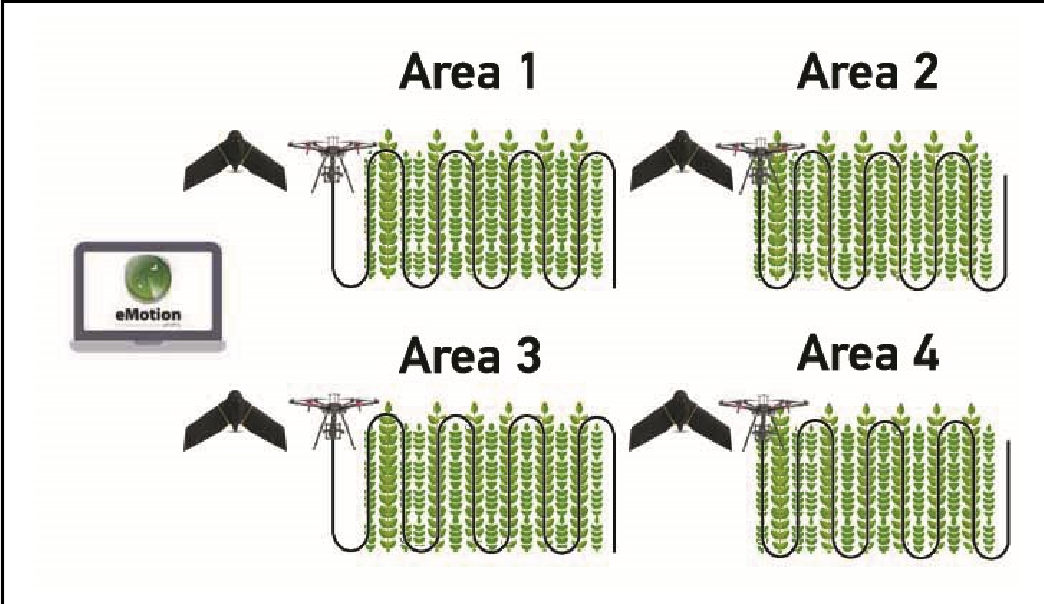
While single UAVs are common, they suffer from limited battery life and slow coverage. This architecture advocates for FANETs (Flying Ad-hoc Networks), where multiple UAVs (fixed-wing for macroscopic views and rotary-wing for detailed inspection) communicate peer-to-peer.
- Mobility Model: The system utilizes the Paparazzi mobility model, allowing UAVs to follow complex, predetermined paths for optimal coverage.
- Data Relay: Distant UAVs use others as relay nodes, ensuring that flight parameters and low-res previews reach the ground station in real-time.
From Raw Data to Actionable Insights
The true value of the architecture lies in the Cloud Computing (CC) backend. The data influx undergoes two primary processing pipelines:
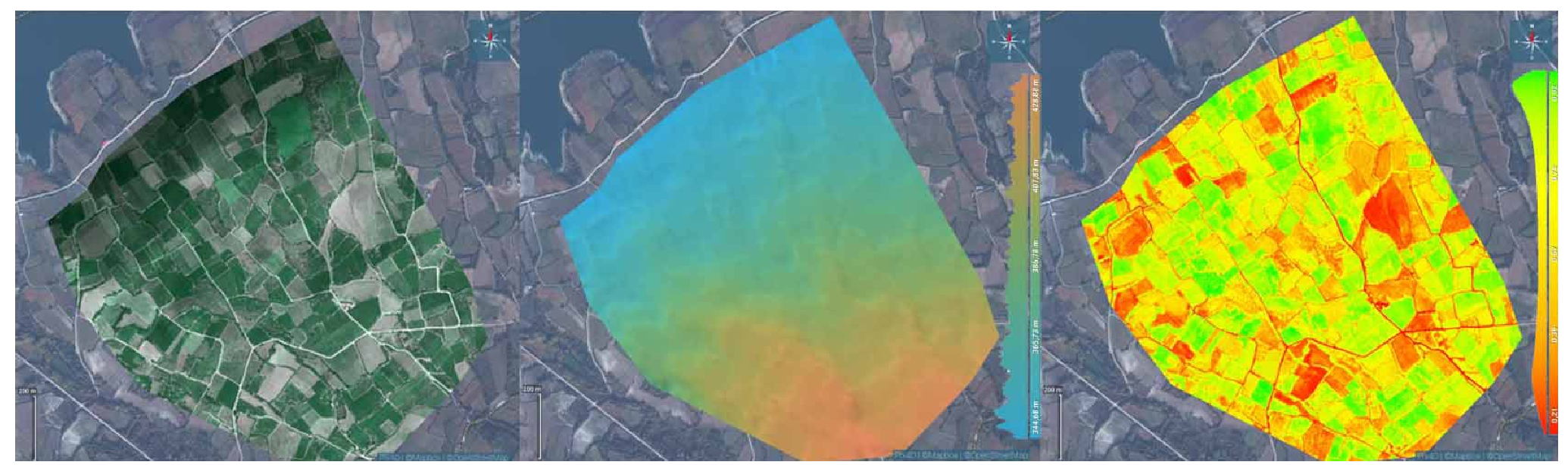
- Computer Vision (CV): UAV multispectral images are processed (using tools like PiX4D) to generate NDVI (Normalized Difference Vegetation Index) maps. These maps highlight "stressed" plants before physical symptoms appear.
- Machine Learning (ML): Textual and environmental data from WSNs are analyzed to predict disease outbreaks based on humidity and soil nutrient trends.
Experimental Potential: Speed and Scalability
The authors highlight that by moving to a FANET deployment, the time required for image collection is slashed by 75%. This is critical for time-sensitive interventions. Furthermore, the use of relay nodes in the swarm allows for monitoring areas far beyond the range of a single radio link from a ground station.
Critical Insight & Future Outlook
This work underscores a significant shift in Ag-Tech: moving from data collection to collaborative scouting. The integration of FANETs introduces "survivability"—if one drone fails, the swarm reconfigures.
Future Directions: While the architecture is robust, the next frontier will be the automated closed-loop response—where the CC system doesn't just alert the farmer but automatically dispatches "spraying swarms" to precise GPS coordinates identified by the "scouting swarms."
Summary of Impact
- Efficiency: 4x faster data collection via UAV swarms.
- Sustainability: Precision treatment reduces the volume of plant protection products.
- Resilience: Multi-layered sensing ensures no single point of failure in crop monitoring.