
RTIS: Revolutionizing Radio Environment Maps with Real-Time Dynamic Incentives
Real-Time Crowdsourcing Incentive for Radio Environment Maps: A Dynamic Pricing Approach
The paper introduces a Real-Time Incentive Solution (RTIS) for building Radio Environment Maps (REMs) through mobile crowdsensing. It utilizes a feature-based spatio-temporal machine learning model combined with a dual-pricing strategy (prepaid and postpaid) to reward users based on data quality and minimized waiting time, achieving superior utility and lower system costs compared to static interpolation methods.
TL;DR
Modern wireless networks are plagued by spectrum scarcity, yet over 30% of cellular bands contain "whitespace" that goes unused because our maps are outdated. This paper presents RTIS (Real-Time Incentive Solution), a system that transforms ordinary mobile users into real-time spectrum sensors. By using a clever dual-payment scheme and an adaptive machine learning model, RTIS provides more accurate maps at a lower cost than previous state-of-the-art methods.
Context: The Static Map Problem
Radio Environment Maps (REMs) are the "Google Maps" of the wireless world. However, while Google knows where traffic is in minutes, current spectrum databases update every several days. This latency makes it impossible to harvest transient spectrum opportunities.
The bottleneck for real-time REMs isn't just the hardware—it's the Economics of Participation. Existing crowdsourcing approaches treat users as static data points and ignore the "waiting cost." If a user has to wait for a central server to decide if their data is "needed" before getting paid, they likely won't participate at all.
Methodology: High-Quality Data via Information Gain
The core innovation of RTIS lies in its Real-Time Incentive Procedure (Algorithm 1). Unlike auction-based models where users bid for tasks, RTIS allows users to trigger sensing tasks immediately.
1. Spatio-Temporal Prediction
The system uses a feature-based model to estimate spectrum usage. It treats geolocation (), time (), and external covariates (like proximity to roads) as inputs. The model is updated iteratively using Adagrad (Adaptive Gradient Descent), which the authors prove converges faster and more accurately for this type of dynamic data.
2. The Pricing Innovation
The payment is split into two logical parts:
- Prepaid (Fixed): A guaranteed base reward that lowers the entry barrier for participants.
- Postpaid (Variable): This is the "smart" part. It is calculated using Mutual Information. If a user's sensing data matches the system's prediction perfectly, it provides little "new info" and the reward is low. If the data reveals a deviation (e.g., a sudden new signal), it represents a high "Information Gain," and the user receives a higher postpaid reward.
 Fig 1. RTIS System Components: Sensors, Web Services, and the Mobile APP Interface.
Experimental Validation
The authors didn't just simulate; they built a full-stack implementation including a cloud spectrum database and a custom mobile app.
Key Findings:
- User Utility: By eliminating the wait-to-be-selected phase, RTIS significantly boosts user utility. The utility remains high even as the "learning interval" grows, whereas traditional methods see a sharp decline.
- System Cost Efficiency: While one might think rewarding more users is expensive, the dynamic learning model ensures that the system doesn't overpay for redundant data.
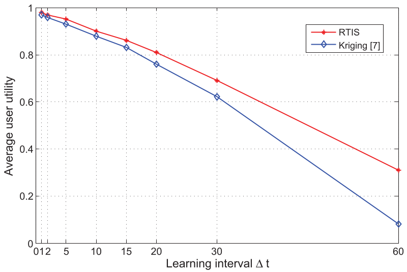 Fig 2. The clear advantage of RTIS in User Utility compared to existing statistical interpolation methods (e.g., Ying et al.).
Critical Perspective: The Road Ahead
While RTIS is a major step forward, two challenges remain:
- Data Integrity: The paper assumes all sensing reports are correct. In a real-world deployment, malicious users might "spoof" data to claim higher postpaid rewards by intentionally creating "information gain."
- Battery Drain: Although the incentive covers "cost," the physical impact on a device’s battery longevity remains a friction point for long-term user retention.
Conclusion
RTIS proves that the key to real-time maps isn't just better math, but better incentive alignment. By valuing data based on its "surprise" (Mutual Information) and paying users instantly, we can create a living, breathing map of our invisible radio landscape.