
Real-Time LWDb: Bridging the Gap Between Slang and Geography on Twitter
Real-Time Local Word Database Construction from Twitter
The paper introduces a real-time system for constructing an up-to-date Local Word Database (LWDb) from streaming geotagged tweets. By adaptively updating spatial locality scores and weights for geographical coordinates, the method achieves superior performance in text-based location estimation compared to static gazetteers and previous SOTA batch-processing methods.
TL;DR
Researchers from Osaka University have developed a system that builds a "living" geographical dictionary in real-time. By monitoring the stream of Twitter, the system identifies local words (like "Reds" for a specific baseball stadium or "Food Fest" for a temporary event) and updates their physical coordinates dynamically. It outperforms traditional expert-curated gazetteers by 2.5x in location estimation accuracy.
Problem & Motivation: The Static Dictionary Trap
Geographical dictionaries (Gazetteers) are usually static. While "Chicago" always stays in Illinois, local language is fluid. Traditional dictionaries fail because:
- Informal Language: They don't include abbreviations, nicknames, or local products.
- Temporal Volatility: Words like "Festival" or "Floods" indicate specific locations only for a short time.
- Usage Skew: Frequent words need different accumulation periods than rare words to prove their "locality."
The authors' insight is simple: To capture the world as it is, a database must not just learn new locations, but also forget old or irrelevant ones.
Methodology: Adaptive Memory and Dynamic Weighting
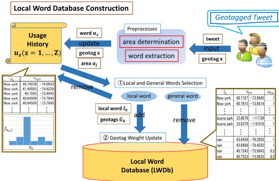
The system follows a three-stage pipeline: Preprocessing, Iterative Selection, and Weight Updating.
1. Spatial Discretization
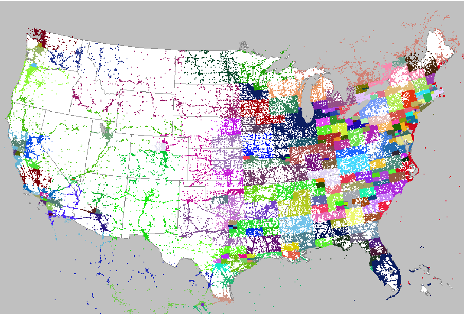
Instead of a uniform grid, the world is divided using a Quadtree Split and Merge algorithm. This ensures that every "cell" in the database represents a similar volume of tweet activity, preventing population density from biasing the local word selection.
2. The Iterative tf-idf Logic
The system tracks the usage history of every noun and compound noun. It calculates a maximum tf-idf score:
- Local Word Addition: If a word's tf-idf exceeds a threshold , it's added to the LWDb.
- General Word Reset: if the score stays below threshold , the history is purged. This "forgetting" allows the system to detect the sudden, brief spatial locality of an event.
3. Coordinate Weighting
Not all geotags are created equal. As a word's usage distribution (histogram ) shifts over time, the system uses a Histogram Intersection to calculate a degradation factor . Old coordinates lose weight () over time if they don't match the new clusters.
Experiments: Performance at Scale
The team tested the system against the U.S. Gazetteer, GeoNames (crowdsourced), and Cheng's batch-process method using 30 days of North American tweets.
Key Metrics:
- Accuracy: The ratio of tweets located within 5/50/100km was significantly higher.
- Dictionary Growth: Starting from zero, the system identified over 93,000 local words in a month, far exceeding the coverage of static lists.
 The charts show how parameters (the locality threshold) influence the number of words and the error distribution.
Why it Wins:
The proposed method successfully identified temporary events (e.g., "Texas Showdown Fest") and ambiguous terms (e.g., "Reds"). While Cheng's method (SOTA batch method) struggled with temporal changes, the proposed iterative weight update kept the coordinates accurate even as events moved or ended.
Depth Insight: The "Forgetting" Advantage
The most striking part of this research is the ablation of the "general word" reset. By clearing the history of words that appear "everywhere," the system reduces noise. In Table IV, the authors show that common words like "park" or "beach" are filtered out because they lack spatial locality, whereas a static Gazetteer would mistakenly use them to guess a location, leading to errors of over 2000km.
Critical Analysis & Conclusion
Takeaway: Real-time social media processing requires a balance between long-term memory (for cities) and short-term focus (for events). This system provides a mathematically grounded way to achieve that balance.
Limitations:
- The method relies heavily on explicit geotags to build the database. As users become more privacy-conscious and disable geotags, the "input" source may dwindle.
- Semantics are still a hurdle; the system cannot distinguish between someone at the "Louisville Zoo" and someone simply talking about it from afar, unless the spatial locality of the aggregate data is strong enough.
Future Work: Integrating Natural Language Processing (NLP) to understand the sentiment or context of why a local word is used could further refine the spatial credibility of the data.