
Crowdsourcing the Commute: Turning Smartphones into Real-Time Transit Sensors
Real-time information about public transport's position using crowdsourcing
The paper proposes a real-time public transport tracking system based on crowdsourcing, specifically designed for urban environments like Athens where vehicles lack built-in GPS. By utilizing passengers' smartphones as geo-tracking nodes, the system offers live bus locations to users via an Android application.
TL;DR
In the absence of expensive built-in GPS hardware on public buses, researchers at Harokopio University have developed a system that uses the "crowd" as the sensor. By turning passengers into data providers via their smartphones, the system provides real-time location tracking for the Athens public transport system, using smart verification algorithms to ensure data integrity.
The "Invisible" Logistics Gap
The discrepancy between scheduled arrival times and reality is a major deterrent for public transport usage. While advanced Intelligent Transportation Systems (ITS) exist, they are often locked behind high infrastructure costs—buses need GPS units, modems, and central integration. In cities facing economic constraints, like Athens during the mid-2010s, "hardware-first" solutions are often off the table.
The authors' insight was simple: The bus might not have a GPS, but the passengers do.
Methodology: Engineering Reliability from Noise
Crowdsourcing data is notoriously messy. A passenger might forget to turn off the tracker, or a malicious user might spoof their location. To combat this, the proposed architecture (see Figure 6) relies on a robust server-side validation layer.
1. Spatial Validation (Route Divergence)
The system uses the Google Directions API to define a "valid path." If a user's GPS coordinates stray beyond a specific threshold from the official route polyline, their data is discarded. This ensures that a person walking near a bus stop isn't mistaken for a bus in motion.
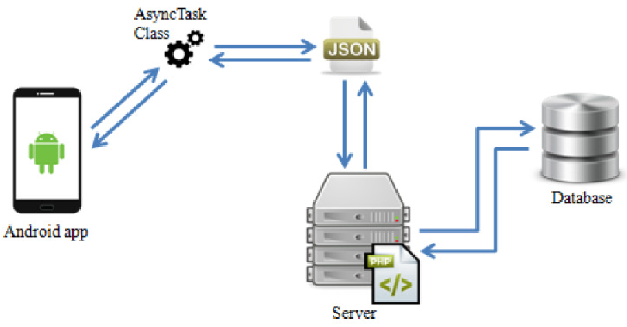 Figure: The data flow from passenger (provider) to server to commuter (consumer).
2. The Multi-Bus Problem (Bus Distinctness)
On busy lines, multiple buses follow the same route. The system uses a proximity filter: if two "providers" are within 300 meters of each other, they are grouped as the same vehicle. If they are further apart, the system instantiates a new bus icon on the map.
3. Temporal Cleanup
To prevent "ghost buses" (where a user leaves the bus but keeps the app running), the system utilizes a Cron job that runs every minute. If a bus location isn't updated for more than 120 seconds, it is wiped from the live map.
From Polyline Decryption to User Notification
Mapping real-world routes proved challenging because basic Map APIs often connect stops with straight lines rather than following actual road curves. The authors utilized polyline-encoding tools to map the "true path," ensuring that the visual representation for the user matches the physical experience.
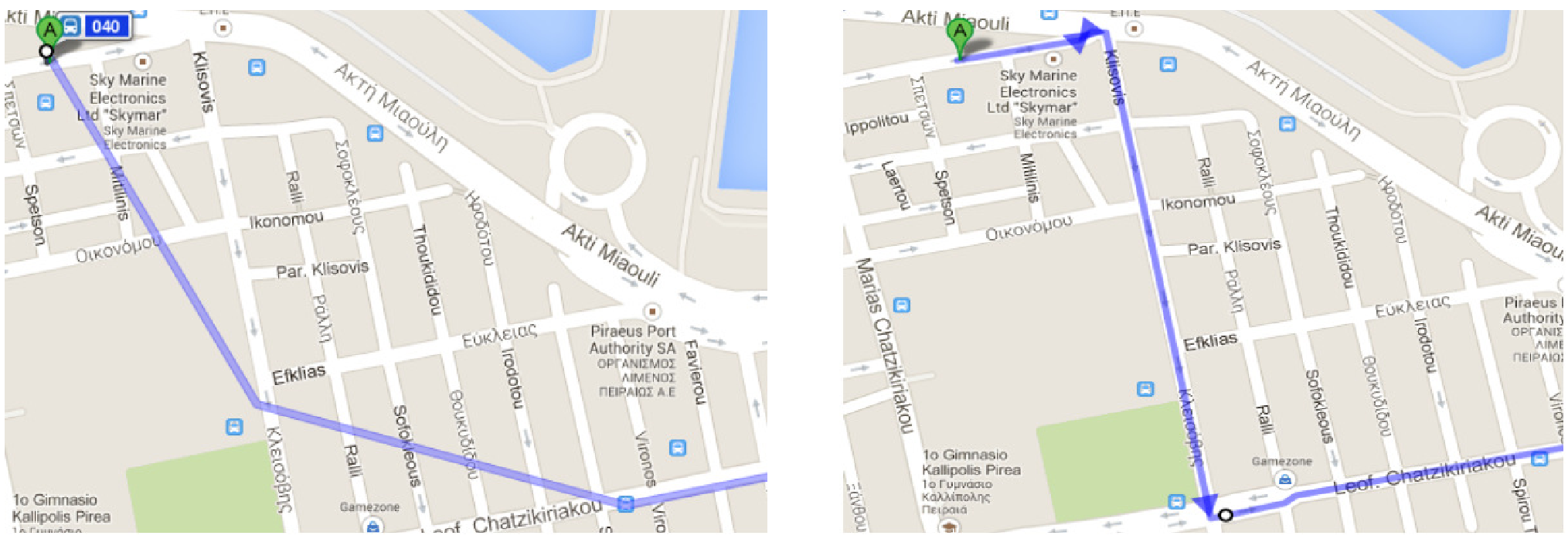 Figure: Comparison between (a) standard API straight-line routes and (b) the decoded real-road path implemented in the app.
Experiments and Key Results
The application functions in two modes: Tracker (Provider) and Viewer (Consumer).
- Update Frequency: Data is transmitted every 10 seconds to balance accuracy with battery consumption.
- Navigation Features: The app provides "get off" notifications for passengers unfamiliar with the route—a feature that bridges the gap between simple tracking and full-scale navigation.
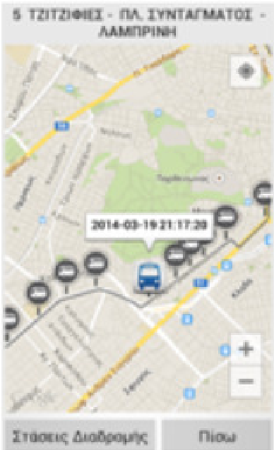 Figure: The Android UI displaying live bus positions and route stops.
Critical Insight & Future Outlook
The primary limitation of this work—as with all crowdsourcing—is the "Critical Mass" problem. The system's utility is exactly zero if no one is on the bus with the app open.
Takeaway: This research proves that decentralized, user-provided data can effectively replace centralized hardware infrastructure. For future deployments, integrating this with "Google Transit" or offering incentives (like digital rewards for "top trackers") would likely be the bridge needed to cross the gap from academic prototype to urban utility.