
Transforming Agriculture: The Power of Multi-Temporal Remote Sensing and Yield Stability
Remote Sensing: Advancing the Science and the Applications to Transform Agriculture
The paper presents a framework for transforming precision agriculture using multi-decadal remote sensing data, focusing on the classification of field productivity into three distinct "Yield Stability Zones." By integrating thermal and optical imagery (NDVI), the authors demonstrate a scalable method to optimize nutrient management and sustainability across 30 million hectares of the US Midwest.
TL;DR
Agriculture is undergoing a digital revolution. This paper outlines how 50 years of remote sensing evolution—culminating in the fusion of thermal and optical data—now allows us to map the US Midwest's "Yield Stability Zones." By categorizing fields into High-Stable, Low-Stable, and Unstable zones, we can reduce nitrogen waste by up to 36% while boosting long-term sustainability.
Context & Positioning: From Snapshots to Stability
For decades, remote sensing was used for "snapshots"—checking if a crop needed water today. This work shifts the paradigm toward Temporal Stability Analysis. It identifies patterns that persist over decades, moving away from simple vegetation indices to a robust, AI-ready framework for precision farming. It positions itself as a critical bridge between raw satellite data and actionable "Digital Agronomy."
The Problem: The High Cost of Uniformity
The "Average Field" is a myth. Within a single field, some areas consistently over-perform, while others are perennial money-losers. Conventional farming applies the same amount of fertilizer and water everywhere, leading to:
- Leaching & Pollution: Excess nitrogen in low-yield areas enters the water table.
- Economic Loss: Farmers waste inputs on areas that lack the soil capacity to produce.
- Ecological Stress: Ignoring the "Unstable" zones leads to inconsistent food security.
Methodology: The Fusion of Thermal and Optical Insights
The authors argue that looking at greenness (NDVI) isn't enough. You must understand the water energy balance.
- Optical (NDVI): Measures crop vigor and light capture efficiency.
- Thermal Imaging: Acts as a proxy for evapotranspiration. Hotter areas often indicate water stress or poor soil water-holding capacity.
- Longitudinal Integration: By analyzing these over a decade (using Landsat), they create a "Stability Map."
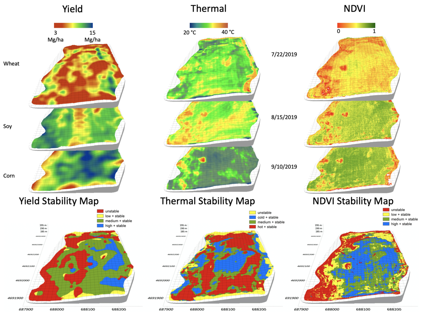 Figure 1: Comparison of stability maps derived from yield monitors via machinery vs. remote thermal and optical sensors, showing high correlation.
The Three Zones
- High-yielding Stable (HS): Areas that consistently hit peak targets. These require optimized inputs to maintain high output.
- Low-yielding Stable (LS): Areas restricted by soil or topography. Adding more fertilizer here is useless. Insight: These areas should be retired or converted to native vegetation.
- Unstable: Areas that fluctuate based on the weather. These are the prime targets for AI/ML adaptive strategies.
Results: Efficiency at Scale
Applying this logic across 30 million hectares of the US Midwest yields staggering results:
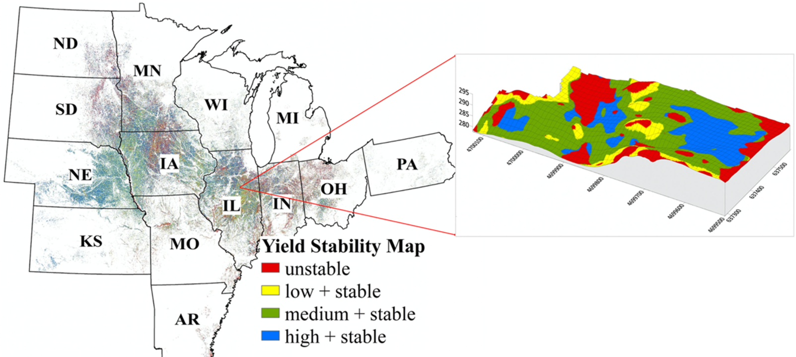 Figure 2: Sub-field scale stability mapping (0.09 ha) for the entire US Midwest corn and soybean belt.
- Nitrogen Reduction: Potential to cut fertilizer use by 36% (65 kg/ha).
- Scalability: The use of Landsat allows this to be implemented globally at no cost to the producer for raw data.
- AI Integration: These maps serve as the "ground truth" for training ML models to predict future yields based on early-season weather patterns.
Critical Insight & Future Outlook
The true value of this work lies in the intentional management of the Low-Stable zone. By identifying areas where farming is inherently inefficient, we can pivot toward biodiversity and bioenergy, creating a "win-win" for profit and the environment.
Limitations: The paper acknowledges the "Unstable" zone is still the hardest to manage. While we can identify it, creating real-time adaptive strategies requires more robust, real-time plant observations to complement the satellite data.
Conclusion: Remote sensing has evolved from a scientific curiosity to the backbone of global food security. The transition to stability-based management represents the next frontier in the "Future Farm."