
Maximizing Vision in Chaos: Resource-Aware Photo Crowdsourcing via DTNs
Resource-Aware Photo Crowdsourcing Through Disruption Tolerant Networks
This paper introduces a resource-aware photo crowdsourcing framework tailored for Disruption Tolerant Networks (DTNs) in emergency scenarios. It utilizes a novel "Photo Coverage Model" based on lightweight metadata and a greedy "Photo Selection Algorithm" to maximize the informational value delivered to a command center while significantly reducing bandwidth and storage overhead.
TL;DR
In disaster zones where 5G/4G fails, how do we get the most critical visual data to rescuers? This paper proposes a system that treats smartphones as intelligent sensors. By using lightweight metadata (like compass direction and GPS) instead of heavy image processing, it filters out redundant photos and ensures a "360-degree" view of targets is delivered through the intermittent connections of Disruption Tolerant Networks (DTNs).
Background: The Infrastructure Gap
In the wake of an earthquake or on a battlefield, data is a lifeline. However, these are precisely the moments when cellular networks collapse. DTNs—where data "hops" from phone to phone until it reaches a satellite up-link—become the last resort. The challenge? Photos are huge, storage is finite, and "contact" between people is fleeting. If everyone uploads the same photo of a collapsed building front, the network chokes, and we lose the chance to see the back of the building where survivors might be.
The Problem: Blind Routing and Redundancy
Prior DTN routing protocols (like Spray&Wait) treat all data packets as equal "black boxes." Even "utility-based" protocols that rank packets by importance fail here because they don't account for redundancy. If two rescuers take nearly identical photos, both photos have high individual "utility," but the second photo adds zero additional value to the command center.
Methodology: Metadata over Pixels
The authors avoid the "energy trap" of running Computer Vision on-device. Instead, they use a Photo Coverage Model.
1. Point vs. Aspect Coverage
- Point Coverage: Is the target in the frame?
- Aspect Coverage: From which angle are we seeing it?
The goal is to maximize the "Aspect Coverage" across all Points of Interest (PoIs). Seeing a building from the North, South, and West is infinitely better than having ten photos from the North.
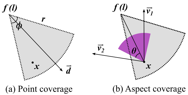 Fig 1: Illustrating how a photo's location (l) and orientation (d) determine the covered aspect of a target.
2. Expected Coverage & Selection
When two nodes meet, they don't just swap everything. They calculate Expected Coverage, which factors in:
- The metadata of photos they already have.
- The probability that they will actually meet the command center (using the PROPHET delivery probability).
- A greedy selection to fill their storage with the most "unique" views available in their combined collection.
Experimental Results
The authors validated their work using a Google Nexus 4 prototype and traces from MIT Reality and Cambridge06.
- Efficiency: The proposed scheme reached near-theoretical maximum coverage. Compared to standard protocols, it reduced the number of photos delivered by an order of magnitude while providing better target visibility.
- Robustness: Even when contact duration was slashed by 80% (simulating people passing each other quickly), the system maintained high performance because it prioritized the most "unique" metadata-ranked photos first.
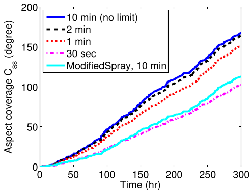 Fig 2: Our scheme (top line) consistently achieves higher point and aspect coverage compared to content-agnostic methods.
Visual Proof
In a real-world test, the algorithm successfully reconstructed a comprehensive view of a historic church by selecting photos from different angles, whereas other methods delivered redundant or irrelevant shots.
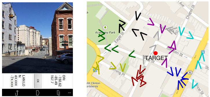 Fig 3: Metadata-driven selection ensures the church is seen from multiple perspectives (V-shapes represent camera orientation).
Critical Insights & Conclusion
This paper shifts the paradigm from "Data Delivery" to "Information Coverage." By using sensor metadata as a proxy for semantic content, the authors bypass the computational limits of mobile devices and the bandwidth limits of DTNs.
Limitations: The model assumes PoIs are static. In a dynamic disaster (e.g., a moving fire front), the value of "aspect coverage" would need to decay over time—a factor the authors acknowledge but leave for future work.
Takeaway: In the future of IoT and mobile sensing, the "Value of Information" (VoI) must be calculated based on what the receiver doesn't know yet, not just what the sender has captured.