
RiskSens: Fusing Social "Whispers" and Satellite "Eyes" for Safer Cities
RiskSens: A Multi-view Learning Approach to Identifying Risky Traffic Locations in Intelligent Transportation Systems Using Social and Remote Sensing
This paper introduces RiskSens, a multi-view learning framework designed to identify high-probability traffic accident locations ("risky locations") within Intelligent Transportation Systems. By fusing unstructured social media reports (Social Sensing) with high-resolution satellite imagery (Remote Sensing), RiskSens achieves superior performance in urban safety mapping, validated on a large-scale New York City dataset.
TL;DR
Researchers from the University of Notre Dame have developed RiskSens, a multi-view learning framework that identifies risky traffic locations by combining the "crowd intelligence" of Twitter with the "visual evidence" of Google Maps satellite imagery. This approach circumvents the lack of official accident databases and achieves over 8% better accuracy than traditional single-source models.
Current Standing: This work is a significant advancement in SOTA (State-of-the-Art) Urban Computing, providing a robust methodology for cities in developing regions where formal accident records are non-existent or restricted.
The "Data Desert" and Location Ambiguity
Identifying "black spots"—areas with high accident frequencies—is the cornerstone of traffic safety. However, researchers face two massive hurdles:
- Data Scarcity: Less than 1% of US municipals have open data portals for accident records. In developing countries, this figure is even lower.
- The Geotagging Paradox: Crowdsourced reports (e.g., social media) are plentiful but vague. A tweet might say "Crash near the Bronx River Parkway," but without a precise GPS pin, this data is useless for pinpointing a 60m x 60m "Sensing Cell."
RiskSens addresses these by treating different data sources as Multiple Views of the same underlying truth.
Methodology: The Architecture of Fusion
The core innovation of RiskSens lies in its three-component architecture: SSFE (Social Sensing), RSFE (Remote Sensing), and MVIF (Information Fusion).
1. Social Sensing (Extracting the "What" and "Where")
The system doesn't just look for keywords. It uses regular expressions to calculate:
- Severity (): Distinguishing a "deadly crash" from a "fender bender."
- Location Probability (): Using Gaussian distributions to model the uncertainty of phrases like "near" or "around" a landmark.
2. Remote Sensing (The Visual Predictors)
Satellite images reveal physical traits correlated with accidents. RiskSens extracts:
- Low-level features: Color histograms and Local Binary Patterns (LBP) to identify intersections or dense zebra crossings.
- High-level features: Using pre-trained CNNs (AlexNet, ResNet, etc.) to recognize complex sceneries like traffic congestion.
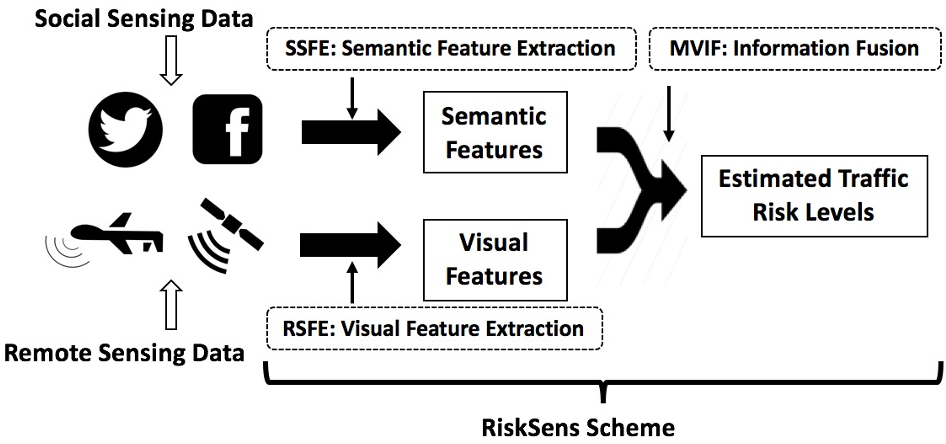
3. Multi-View Information Fusion (MVIF)
Instead of a simple "average," RiskSens treats each model (social-only, remote-only, or hybrid) as a "View."
- Dynamic Weighting: It uses an enhanced Maximum Likelihood Estimation (MLE) to figure out which "view" is typically more accurate and gives it more voting power.
- Recursive View Elimination (RVE): It iteratively removes the "liars" or the consistently inaccurate views to sharpen the final prediction.
Experimental Results: Proving the Power of Two
Using 2.3 million tweets and over 2.1 million satellite images from New York City (ground-truthed by NYPD records), the results were conclusive.
| Number of Cells | RiskSens Accuracy | Best Baseline | Improvement |
|---|---|---|---|
| 2000 | 0.549 | 0.506 | +4.3% |
| 6000 | 0.580 | 0.499 | +8.1% |
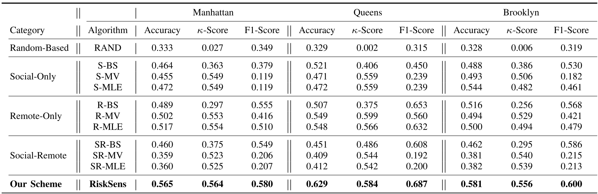
The ablation study revealed that removing either Social or Remote views resulted in a ~10% drop in accuracy, confirming that the two paradigms are highly complementary.
Critical Insight & Future Outlook
Takeaway: RiskSens succeeds because it embraces uncertainty. By mathematically modeling the "vagueness" of a human tweet and the "visual noise" of a satellite image, it extracts signal from data that was previously considered too "dirty" for high-stakes safety tasks.
Limitations: The model currently assumes a static risk level. However, urban risk is dynamic (day vs. night, rain vs. shine). Future iterations of RiskSens could integrate real-time weather data or temporal social media trends to provide "Safety Forecasting" in real-time.
Conclusion: This research lays the analytical foundation for a new generation of "Zero-Infrastructure" traffic safety tools—protecting citizens using only the data they already generate and the imagery we already capture.