
Safe Street Rangers: Crowdsourcing the "Hidden" Factors of Urban Safety
Safe Street Rangers: Crowdsourcing Approach for Monitoring and Repor8ng Street Safety
Safe Street Rangers (SSR) is a crowdsourcing system designed to monitor and report urban street safety through a mobile application. It utilizes local "rangers" to evaluate street segments across seven distinct safety dimensions (e.g., brightness, road condition, animals) for both walking and driving modes.
TL;DR
Safe Street Rangers (SSR) is a community-driven platform that allows citizens to act as "Rangers," reporting street-level safety concerns across seven qualitative dimensions. By moving beyond simple accident tracking to monitor environmental factors like lighting and road conditions, the system creates a high-resolution safety map for both pedestrians and drivers.
Context: Why Official Data Isn't Enough
When we think of street safety, we often think of accident statistics. However, a street can be "unsafe" long before a crash occurs—think of a poorly lit alleyway, a street with aggressive stray dogs, or a segment with crumbling pavement.
Current solutions (Prior Work) are often siloed:
- Emergency Apps (e.g., bSafe): Reactive rather than proactive.
- Sensor Apps (e.g., WalkSafe): Limited by hardware and focused only on immediate vehicle threats.
The authors argue that the Wisdom of the Crowd is the most effective sensor for capturing these nuanced, environmental safety factors that local residents know best.
Methodology: The Ranger Core
The SSR system is built on a robust loop of Reporting → Verification → Monitoring.
1. The Multi-Dimensional Safety Model
Unlike simple "thumbs up/down" systems, SSR requires rangers to rate seven specific aspects:
- Traffic Signs & Road Obstacles
- Brightness & Road Condition
- Animals, Solitariness, and Traffic Accidents
2. Solving the "Overlapping Segment" Problem
A major technical challenge in street crowdsourcing is that users rarely report the exact same start and end points for a street segment. The developers solved this by:
- Waypoint Mapping: Converting segments into a series of waypoints using the Google Maps API.
- Spatial Averaging: Using a linked-list structure in the database to identify overlapping waypoints and calculating a running average of safety ratings.
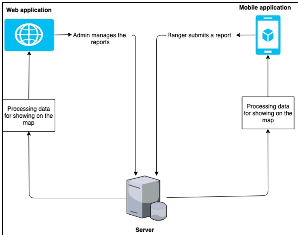 Figure 1: The SSR System Overview showing the flow between Rangers (Mobile), Admins (Web), and the Data Server.
User Experience & Insights
The research included a field test with real users, categorized by gender and age.
Key Findings:
- High Utility, Low Ease-of-Use: While users found the app incredibly useful (4.53/5), they struggled with the interface (3.53/5).
- The Gender/Age Gap: Female users and those in the 30-39 age group reported higher difficulty in navigating the app without instructions. This suggests that for urban safety apps, UI/UX is not just a "bonus"—it's a critical safety feature itself.
- The Social Factor: Users expressed a strong desire to share results on social media, indicating that "social proof" is a primary motivator for contributing to crowdsourced platforms.
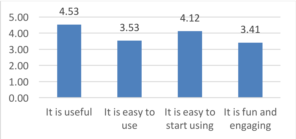 Figure 2: Overall UX study results highlighting the high perceived usefulness vs. lower ease of use.
Critical Analysis & Conclusion
The Safe Street Rangers project proves that people are willing to "look out for each other" if given the right tools. However, the study identifies two major hurdles for the future of such systems:
- Verification Bottleneck: Currently, an admin must manually approve reports. To scale to a city-wide level, this would require automated verification (perhaps via AI image analysis).
- Sustainability: Maintaining a "crowd" requires more than just utility; it requires engagement. Future iterations must look toward gamification to keep Rangers active.
The Takeaway: Urban safety is a collaborative effort. By quantifying "soft" data like solitariness and lighting, SSR provides a blueprint for how cities can use ICT to create safer, more informed communities.