
Scalable Detection of Rural Schools: Mapping Education from Space with Unsupervised Learning
Scalable Detection of Rural Schools in Africa Using Convolutional Neural Networks and Satellite Imagery
This paper presents an unsupervised machine learning pipeline using a pre-trained ResNet-50 and k-means clustering to detect rural schools in Liberia via high-resolution satellite imagery (0.5m/pixel). The method, developed with UNICEF, successfully identifies significant numbers of schools while dramatically reducing the manual search space for humanitarian aid.
TL;DR
In a collaborative effort between UC San Diego and UNICEF, researchers have developed a scalable, cost-effective way to find rural schools using satellite imagery and AI. By using a pre-trained ResNet-50 and unsupervised clustering, they reduced the manual data inspection workload by 98.8% while maintaining an 80% recall rate. This work provides a vital blueprint for mapping infrastructure in regions where ground-truth data is missing or "noisy."
The "Data Desert" Problem
Global organizations like UNICEF aim to bridge the digital divide, but you can't connect a school if you don't know where it is. In many parts of sub-Saharan Africa, official school records are incomplete or inaccurate. While high-resolution satellite imagery (0.5m/pixel) covers the whole planet, the volume of data is overwhelming.
The challenge isn't just "finding" schools—it is doing so when your training labels are messy. Traditional supervised learning fails when labels are offset by several meters or decades old. The authors' insight: Use AI to organize the world's imagery first, then find the patterns.
Methodology: Feature Extraction & Manifold Learning
The team utilized an "unsupervised" pipeline, meaning the AI wasn't explicitly told what a school looks like during the training phase.
- Tiling: Large satellite mosaics were sliced into 200x200 pixel tiles.
- The ResNet Backbone: Each tile was passed through a ResNet-50 (pre-trained on ImageNet). Instead of classification, they extracted the 2,048-dimensional feature vector from the last pooling layer.
- Clustering (k-means): Tiles with similar visual patterns (forests, roads, dense housing) were grouped into 50 clusters.
- PCA Alignment: To make sense of these clusters, they used Principal Component Analysis (PCA) to order clusters along a gradient from "undeveloped forest" to "high structuredness."
 Figure 1: The proposed pipeline—from raw satellite imagery to feature extraction and categorized clusters.
Exploring Rural Settlements
One of the most profound findings was the "spatial logic" the AI discovered. The clustering didn't just find schools; it mapped the anatomy of Liberian villages.
- Cluster 47 (Blue): Settlement outskirts.
- Cluster 48 (Yellow): Concentric rings within the outskirts.
- Cluster 49 (White): The village center.
Most schools were found in Cluster 39 (outlying structures) or clusters representing the outskirts. This confirms a socio-economic intuition: schools in rural Liberia are often built slightly away from the dense center of a settlement.
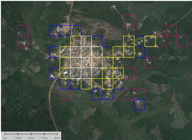 Figure 2: Spatial distribution of clusters showing how the model distinguishes between settlement centers and outskirts (where schools are often located).
Performance vs. Cost
A critical part of this research is the Cost Analysis. While a supervised model (Logistic Regression on CNN features) achieves slightly better precision (8% vs 4% at 80% recall), the supervised model requires a massive, perfectly labeled dataset.
The authors argue that the False Discovery Rate (FDR) of unsupervised learning is acceptable because the goal is to reduce the search space. In their test, they reduced 71,448 images down to 828 candidate images. Inspecting 828 images is a afternoon's work for a human; inspecting 71,000 is an impossibility.
| Metric | Unsupervised Method | Supervised Method |
|---|---|---|
| Recall | 80% | 80% |
| Precision | 4% | 8% |
| Search Space Reduction | ~99% | ~99.5% |
| Relative Cost | 1.0x | 2.27x |
Critical Analysis & Conclusion
Takeaway
The value of this paper isn't in a "new architecture," but in the application of manifold learning to humanitarian logistics. It proves that "off-the-shelf" features from ImageNet are robust enough to distinguish subtle rural architectural features from forest and soil.
Limitations & Future Work
The primary hurdle remains Precision. A 4% precision means aid workers will still see many "false alarms" (houses or clinics that look like schools). The authors suggest two brilliant paths forward:
- Multi-spectral Imagery: Using thermal or non-visible bands could distinguish school building materials (like specific metal roofing) from regular dwellings.
- Temporal Resolution: Schools have specific activity patterns (visible through higher-frequency satellite updates).
Ultimately, this study turns "Big Data" into "Actionable Data," providing a scalable path toward the UN's Sustainable Development Goal of quality education for every child.