
SCENT: Transforming Citizens into Environmental 'Eyes' for Flood Prediction
SCENT: Citizen Sourced Data in Support of Environmental Monitoring
SCENT is a Horizon 2020 project that introduces a collaborative "Smart Toolbox" for environmental monitoring, specifically focusing on land-cover changes and flood prediction. By integrating citizen-sourced data via smartphones, portable sensors, and serious gaming with machine learning and hydrodynamic models (HEC-RAS), it achieves a people-centric observation web that complements traditional satellite and in-situ infrastructure.
TL;DR
The SCENT project (Smart Toolbox for Engaging Citizens into a People-Centric Observation Web) is an EU-funded initiative that bridges the gap between professional environmental monitoring and grassroots community action. By leveraging a suite of mobile apps, low-cost sensors, and machine learning, SCENT captures hyper-local land-cover data to significantly improve the accuracy of flood prediction models in vulnerable regions like the Danube Delta.
Problem & Motivation: The Limits of Traditional Remote Sensing
While programs like the Copernicus Land Monitoring service offer massive Earth observation capacity, they face a "last-mile" problem. Satellites can miss rapid, small-scale land-use changes—such as new urban surfaces or altered vegetation in wetlands—that drastically affect how water flows during a flood.
Maintaining a dense enough network of professional ground sensors to capture these changes is financially unsustainable. Furthermore, there is a socio-political disconnect: citizens living in flood-prone areas often feel like passive victims rather than active contributors to the policy and science that protects them. SCENT's core insight is that citizens are mobile sensor hubs capable of providing high-frequent, ground-level visual data that satellites simply cannot match.
Methodology: The SCENT "Smart Toolbox"
The SCENT architecture is a sophisticated pipeline that converts a casual photo taken by a hiker into actionable data for a hydroinformatics expert.
1. The Intelligence Engine & Data Collection
The SCENT Intelligence Engine (SIE) employs machine learning to segment and classify outdoor images. It analyzes features like texture, color, and shape to distinguish between, for example, a paved road and a grassy bank. To ensure high data quality, the project uses a novel approach:
- Serious Gaming: Users "play" a game to annotate and validate image content.
- CAPTCHA Plugins: Everyday internet tasks are repurposed to help classify environmental images.
2. Standardizing the "Crowd"
To be useful for authorities, crowdsourced data must be "harmonized." SCENT uses an open-source platform to align data with the INSPIRE directives and OGC standards, ensuring that a photo from a smartphone is as technically rigorous as a reading from a government sensor.
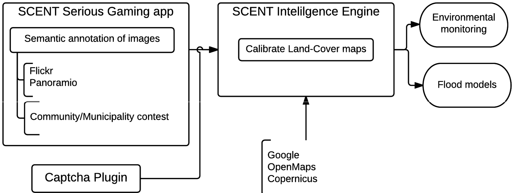 Figure 1: The holistic SCENT ecosystem connecting citizens to the GEOSS portal.
Experiments & Results: Improving Flood Models
The toolbox's efficacy was tested in two diverse environments: the urbanized Kifisos catchment in Greece and the rural Danube Delta in Romania.
The project used the HEC-RAS (Hydrologic Engineering Center's River Analysis System) to model water propagation. A critical variable in these models is the "roughness coefficient," which depends entirely on land cover. By using SCENT’s improved, citizen-verified land-cover maps, researchers could define the flow over land much more precisely.
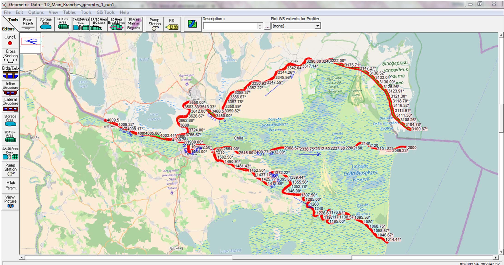 Figure 2: River network modeling for the Danube Delta.
Key Results:
- Successfully demonstrated that citizen-led observations can fill gaps in the Copernicus Land Monitoring service.
- Achieved a quantifiable improvement in flood extent mapping (as seen in Figure 3) by refining the input data for hydrodynamic models.
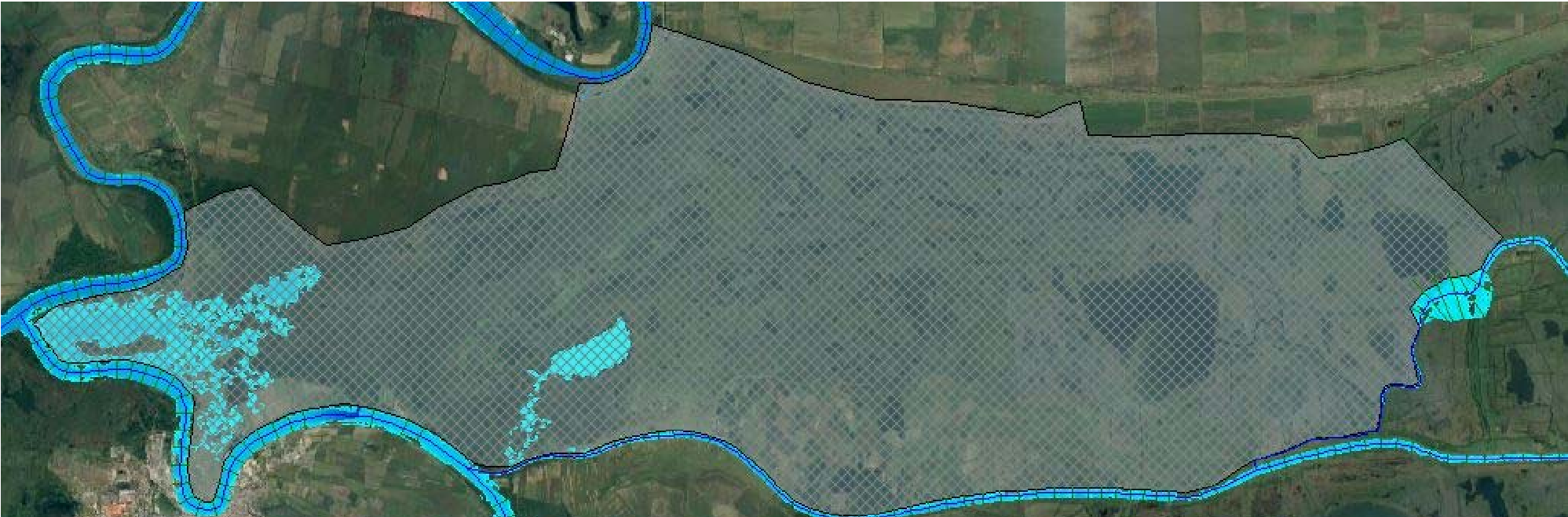 Figure 3: Visualized flood extent results derived from harmonized data.
Critical Analysis & Conclusion
The true value of SCENT is not just the software, but the hybrid intelligence model. It acknowledges that while AI is great at processing scale, humans are superior at interpreting context in complex natural environments (e.g., distinguishing between different types of marshland vegetation).
Limitations: The success of the project heavily relies on "Participant Sustainability." Keeping citizens motivated after the novelty of a "serious game" wears off is a known challenge in crowdsourcing.
Future Outlook: As smartphones become equipped with even more advanced sensors (e.g., LiDAR in newer models), the SCENT framework could evolve to provide high-resolution Digital Elevation Models (DEM) from the ground up, further revolutionizing how we predict and survive natural disasters.