
SRRM: Precision Downscaling of Microwave Brightness for Heterogeneous Agriculture
13017_Utilizing Self-Regularized Regressive Models to Downscale Microwave Brightness Temperatures for Agricultural Land Covers in the SMAPVEX-12 Region.
This paper introduces a Self-Regularized Regressive Model (SRRM) to downscale satellite microwave brightness temperatures () from 10–40 km to km. By leveraging higher-order correlations between and auxiliary variables (LST, LAI, Precipitation) through a coupled clustering-regression framework, the method achieves SOTA performance in heterogeneous agricultural landscapes.
TL;DR
Researchers have developed a novel Self-Regularized Regressive Model (SRRM) that directly downscales satellite microwave brightness temperatures () from 40 km to 1 km. By integrating information-theoretic clustering with kernel regression, the method preserves critical spatial heterogeneity, achieving an RMSE as low as 1.2 K in synthetic tests and providing a robust tool for site-specific agricultural management.
Background & Motivation: The Resolution Gap
Satellite missions like SMOS and SMAP are gold mines for soil moisture (SM) data, but their "native" resolution of 36–50 km is far too coarse for a typical farm. Current "Downscaling" often targets the SM product itself, but there is a catch: the inverse modeling used to get SM from is already error-prone. Downscaling a biased product only compounds the error.
The authors argue for a Direct Downscaling approach—disaggregating the raw signal first. The challenge lies in the "ill-conditioned" nature of the problem: one coarse pixel contains a multitude of possible fine-scale configurations. To solve this, the paper utilizes auxiliary data—Land Surface Temperature (LST), Leaf Area Index (LAI), and Precipitation (PPT)—to regularize the solution.
Methodology: Clustering Meets Kernel Regression
The SRRM framework operates in two distinct, high-impact stages:
1. Information-Theoretic Clustering
Instead of treating the entire landscape with a single global model (which fails in heterogeneous areas), the algorithm uses a Cauchy-Schwarz cost function to group pixels into "regions of similarity."
- Proportional Membership: Unlike hard K-means, pixels can have fractional membership in multiple clusters, which is essential for "edge" pixels that share characteristics of both bare soil and dense crop cover.
2. Kernel-Based Ridge Regression
Within each cluster, the model fits a non-linear function using a Reproducing Kernel Hilbert Space (RKHS). This allows the model to capture higher-order correlations between the auxiliary variables and the microwave signal that simple linear models miss.
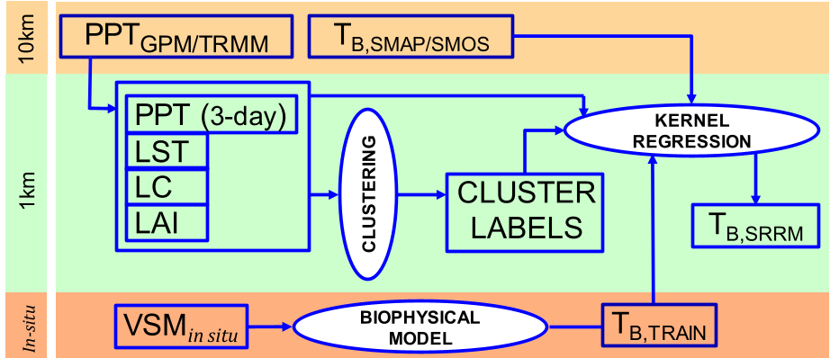 Figure 1: The SRRM workflow showing the integration of auxiliary satellite data and the two-stage clustering-regression process.
Experimental Results: Proving the Precision
The model was validated using a year-long synthetic dataset and real-world data from the SMAPVEX-12 campaign in Canada.
- Synthetic Performance: During the non-vegetated season, the RMSE was a remarkable 1.2 K. During complex growing seasons (corn and cotton), it remained a respectable 5.76 K.
- The "Clustering" Advantage: The study proved that omitting the clustering step (relying on a single regression model) caused the standard deviation of error to jump by 8 K, highlighting that "local" expertise is mandatory for downscaling.
- Real-World Validation: Using SMOS data, the SRRM-downscaled achieved an RMSD of approx. 6.2 K compared to PALS airborne data. The error was slightly higher due to biases in TRMM precipitation data, but when in-situ PPT was used, errors dropped by an additional 2.5 K.
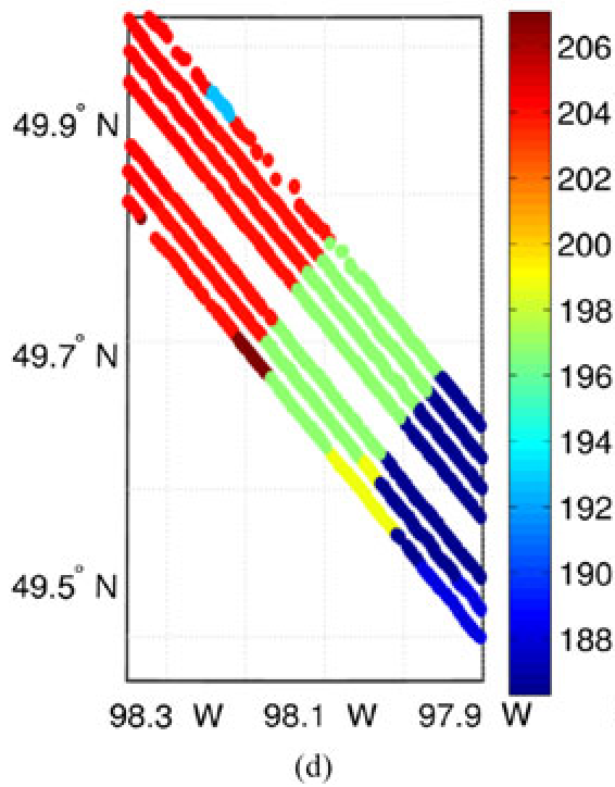 Figure 2: Spatial comparison of (e) Downscaled TB vs (f) Airborne TB on DoY 183. Note the successful capture of fine-scale trends absent in the coarse SMOS data (d).
Critical Insight & Outlook
The SRRM's success hinges on its self-regularization. By utilizing the spatial structure of auxiliary variables, it effectively "hallucinates" the fine-scale with physical consistency.
Limitations: The model is sensitive to the quality of auxiliary inputs, particularly precipitation. In the SMAPVEX-12 trial, regional biases in satellite rainfall products (TRMM) were the primary source of error.
Future Work: Moving forward, the integration of this downscaled into crop growth models (like DSSAT) could revolutionize yield forecasting, allowing farmers to see sub-kilometer moisture stress before it manifests as visible crop damage.