
SmartPhoto: Boosting Crowdsourced Image Utility through Geometric Metadata
SmartPhoto: A Resource-Aware Crowdsourcing Approach for Image Sensing with Smartphones
SmartPhoto is a resource-aware crowdsourcing framework that selects high-quality photos using lightweight metadata (GPS, orientation, FOV) instead of heavy image processing. It achieves State-of-the-Art selection efficiency by framing photo utility as a geometric coverage problem and solving it via greedy algorithms with provable approximation bounds.
TL;DR
In emergency scenarios like post-earthquake recovery, bandwidth is gold. SmartPhoto is a framework that avoids the "blind upload" problem of crowdsourcing. Instead of using heavy AI to scan image pixels, it uses lightweight sensor metadata (GPS + Orientation) to mathematically predict which photos are most useful, reducing data redundancy by over 70% while maintaining perfect 360-degree coverage of targets.
The Problem: The "Pixel-Heavy" Bottleneck
When thousands of users upload photos of a landmark or disaster site, two things happen:
- Redundancy: 90% of the photos capture the same "front view," wasting bandwidth.
- Resource Exhaustion: Modern LLMs or CV models could filter these, but running them on a smartphone kills the battery, and running them on a server requires the data to be uploaded first—a catch-22.
Existing solutions mostly looked at where a user was. But location is not vision. If two people stand at the same GPS coordinate but face opposite directions, their "utility" to a map service is completely different.
Methodology: The Geometry of Usefulness
1. Defining "Utility" via Aspects
SmartPhoto treats every target (e.g., a building) as a circle with 360 degrees of "aspects." A photo's utility is defined by how many of these degrees it covers. This transforms a computer vision problem into a Geometric Set Cover Problem.
2. The Hybrid & Enhanced Sensing
The biggest technical hurdle was sensor noise. Raw smartphone compasses are notoriously jittery. This paper introduces:
- Hybrid Filter: Fusing Gyroscope and Magnetometer data to stop "drifting."
- Orthonormalization: Using the Gram-Schmidt process to ensure the rotation matrix remains mathematically valid even with sensor error.

3. Solving Occlusion without Pixels
How do you know if a tree is blocking the building without looking at the photo? The authors use Depth-of-Field (DOF) metadata. By comparing the GPS distance to the target with the camera's focus distance, SmartPhoto identifies "occluded" or "out-of-focus" shots locally on the device, dropping them before they ever touch the network.
Experiments & Results
The authors tested this on a real-world campus dataset involving a Bell Tower.
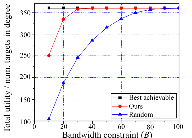
- Max-Utility: Under a strict budget of only choosing 4 photos from 30 candidates, SmartPhoto selected views from four distinct cardinal directions. Random selection often picked overlapping views or missed the target entirely.
- Efficiency: To achieve a full 360-degree reconstruction, a random approach required 21 photos. SmartPhoto reached the same coverage with just 6 photos.
Critical Insight & Analysis
The brilliance of SmartPhoto lies in its Competitive Analysis. The authors didn't just write a heuristic; they proved that their greedy selection is optimal. This means that even without knowing which photos will come in the future (the "Online" problem), the system is guaranteed to be within a specific range of the best possible theoretical selection.
Limitations: The system assumes targets are static points. For dynamic events (e.g., a moving protest), the "metadata" would need a temporal decay factor, as the utility of a 5-minute-old photo of a moving person drops to zero regardless of its geometric angle.
Conclusion
SmartPhoto shifts the paradigm from "Content-Aware" to "Resource-Aware" sensing. By treating smartphone sensors as a distributed camera array and applying rigorous geometric optimization, it paves the way for efficient, disaster-resilient crowdsourcing.
Takeaway for Researchers
If you are building visual sensing systems, don't ignore the extrinsic parameters of the camera. The metadata is often "free" and can solve optimization problems that are too expensive for even the most advanced Neural Networks to handle at the edge.