
SmartPhoto: Optimizing Crowdsourced Image Sensing via Metadata-Driven Selection
SmartPhoto: A Resource-Aware Crowdsourcing Approach for Image Sensing with Smartphones
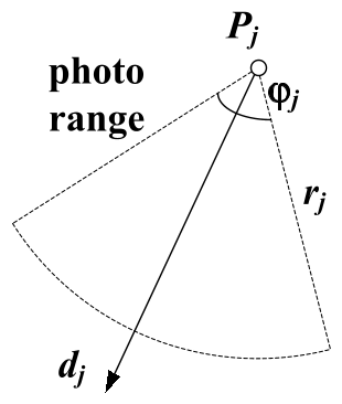
SmartPhoto is a resource-aware crowdsourcing framework designed to optimize the selection and transmission of images from smartphones. It uses lightweight sensor metadata (GPS, orientation, FoV) to quantify photo "utility" through a geometric coverage model, achieving SOTA redundancy reduction without expensive content-based image processing.
TL;DR
SmartPhoto is a framework that solves the "data deluge" in mobile crowdsourcing by selecting the most useful photos based on sensor metadata (position, orientation, and focus) rather than the images themselves. By treating photo selection as a geometric coverage problem, it maximizes target visibility while minimizing bandwidth and storage usage, making it ideal for disaster recovery and map services.
Background: Beyond GPS Pins
In the era of Instagram and emergency citizen journalism, the problem isn't getting photos—it's managing them. Legacy systems often rely on GPS coordinates to find images of a landmark. However, a user at a specific coordinate could be facing a building, a tree, or their own feet. Traditional Content-Based Image Retrieval (CBIR) could solve this, but running heavy AI models on thousands of high-res photos at the "edge" (smartphone) or uploading them all to a server is a bandwidth nightmare.
SmartPhoto identifies a high-value middle ground: Metadata-Aware Selection.
The Core Intuition: Photo Utility as "Aspect Coverage"
The researchers argue that a target (e.g., a bell tower) is only "covered" if it is photographed from multiple angles (aspects).
- The Utility Model: They define a photo's utility by how many 1-degree "slices" of a target's 360-degree surround it covers.
- The Math: This transforms the selection process into a Maximum Coverage Problem. Since this is NP-hard, the authors use a Greedy Selection Algorithm with a proven (1 - 1/e) approximation bound.
Methodology: Fixing "Noisy" Sensors
The success of SmartPhoto depends on the accuracy of the smartphone's orientation (compass). Standard mobile sensors are notoriously noisy due to electromagnetic interference and jerky movements.
1. The Enhanced Orientation Method
The authors didn't just accept raw sensor data. They developed a three-stage pipeline:
- Hybrid Fusion: Combining Accelerometer/Magnetometer readings with Gyroscope data using a low-pass IIR filter.
- Orthonormalization: Applying the Gram-Schmidt process to the rotation matrix to ensure the coordinate axes remain perfectly orthogonal, correcting mathematical drift.
2. Edge-Side Filtering (OCoF)
To avoid "valid looking" but useless photos (e.g., a building blocked by a passing bus), SmartPhoto uses Depth-of-Field (DOF) analysis. By comparing the calculated distance to the target (via GPS) with the camera's focus distance, it can discard out-of-focus or occluded images before they ever leave the device.
Experimental Performance
The system was tested on a fleet of Android devices (Nexus S to Nexus 4).
- Orientation Accuracy: Their "Enhanced" method achieved an azimuth error of just 1.3° on modern hardware, a massive improvement over the ~10° error seen in standard implementations.
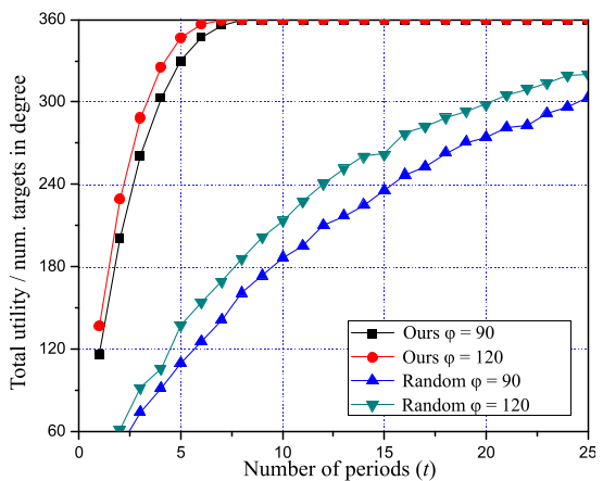
- Transmission Efficiency: In simulations of 30 targets, SmartPhoto's greedy algorithm reached near-total coverage (360° utility) using only a fraction of the photos required by random-selection methods.
Deep Insight: Why This Matters
SmartPhoto demonstrates a critical principle for the future of the IoT: Metadata is a first-class citizen. Instead of trying to "understand" pixels via expensive AI, we can use the physical context of the sensor to make 90% of the decisions.
Limitations: The system assumes targets are static and their locations are known. For dynamic events (e.g., a moving protest), the "Target Distribution" would need to be updated in real-time.
Takeaway
By leveraging the "physics of the photo" through sensor fusion and geometric coverage models, SmartPhoto provides a blueprint for efficient, large-scale mobile sensing that respects the constraints of real-world wireless networks.