
Decoding the Freshening: Using RIM to Reconcile SMOS Salinity with Deep Ocean Reality
SMOS Near-Surface Salinity Stratification Under Rainy Conditions
This paper adapts and validates the Rain Impact Model (RIM) for the SMOS satellite mission to analyze transient near-surface sea surface salinity (SSS) stratification caused by rainfall. By integrating SMOS L-band radiometer data with CMORPH precipitation history, the study achieves a robust prediction of local salinity dilution, matching SOTA performance previously seen with the Aquarius mission.
TL;DR
Satellite sensors see the ocean's "skin," but oceanographers need to know what's happening in the "body." This paper validates the Rain Impact Model (RIM) for the SMOS mission, proving that transient surface freshening caused by rain—which can skew data by over 1 psu—can be accurately predicted using precipitation history and 1-D diffusion physics.
Background: The Depth Dilemma
In the world of physical oceanography, there is a persistent gap between remote sensing and in situ measurement. Satellites like SMOS (Soil Moisture Ocean Salinity) and Aquarius use L-band radiometers to measure Sea Surface Salinity (SSS). However, physics dictates that these sensors only penetrate the top 1 cm of the water. In contrast, buoy data and models like HYCOM represent "bulk" salinity at depths of 5-10 meters.
Under stable conditions, the ocean is well-mixed. But when it rains, a "lens" of fresh water forms on the surface. This creates stratification, making the satellite see a much fresher ocean than actually exists at depth.
Methodology: The Physics of Dilution
To bridge this gap, the researchers adapted the Rain Impact Model (RIM). Instead of treating salinity as a static value, RIM views it as a dynamic process controlled by the downward vertical diffusion of freshwater pulses.
The Core Mechanism
RIM utilizes three primary inputs:
- Initialization: Bulk salinity from HYCOM (the deep-water baseline).
- Rain History: 24 hours of precipitation data from CMORPH (30-minute resolution).
- Mathematical Superposition: A series of rain impulse functions that calculate how each rain event over the last day contributes to the current surface salinity at a depth of 0.005m.
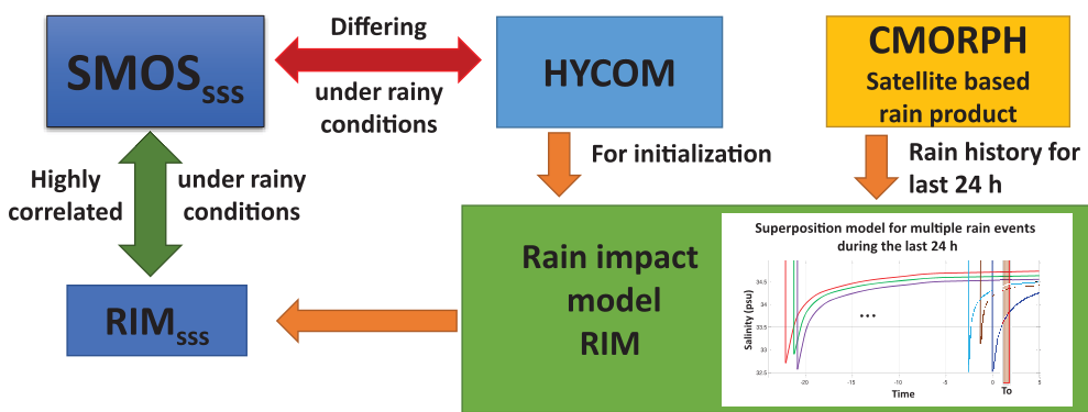 Figure 1: The RIM processing chain integrating satellite observation time with rainfall accumulation history.
The model relies on the vertical eddy diffusivity coefficient () and empirical coefficients () to simulate how the freshwater pulse spreads downward over time.
Experimental Results: SMOS vs. The Rain
The study processed over 2000 SMOS orbits, specifically looking for rain events where SMOS and HYCOM disagreed.
Case Study: Capturing the Transient Lens
In a study of a rain event in May 2012, SMOS detected a significant salinity drop (>1 psu). HYCOM, looking at the bulk water, saw nothing. RIM, however, successfully reconstructed the SMOS pattern by looking at the 24-hour rain history, proving that the localized "freshening" was a predictable physical event rather than sensor noise.
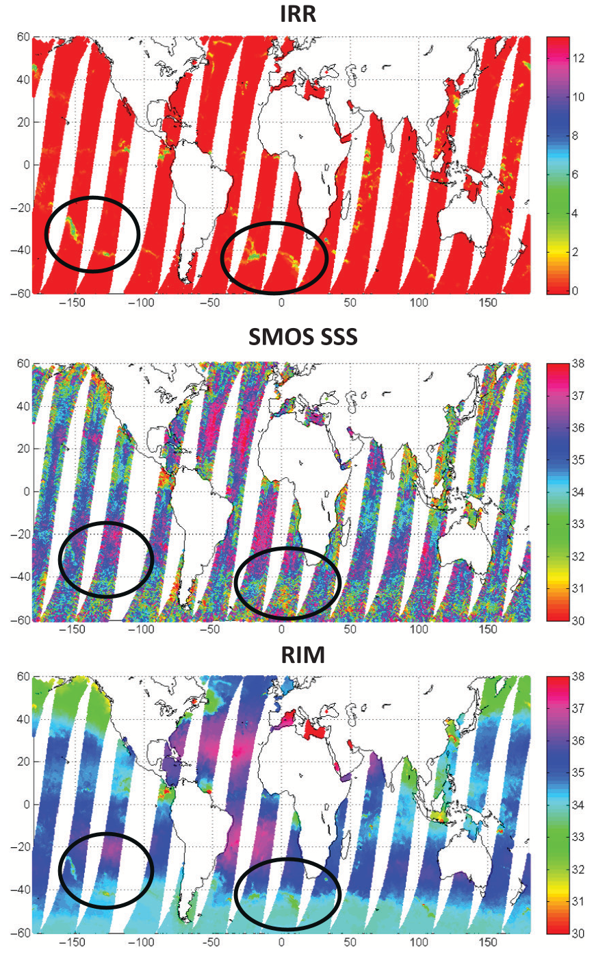 Figure 2: Orbit comparisons showing the high correlation between high rain rates (IRR) and SSS decrements in both SMOS observations and RIM predictions.
The Wind Factor
A critical discovery in this validation was the role of mechanical mixing. The authors found that even during heavy rain, stratification rarely persists if wind speeds exceed 10-12 m/s. The energy from the wind-driven waves effectively "stirs" the fresh water back into the brine, neutralizing the RIM's predicted freshening.
Critical Insight & SOTA Comparison
One of the paper's strongest contributions is the "Anomalies Comparison." By plotting the SSS anomaly (Satellite SSS - HYCOM SSS) against the Instantaneous Rain Rate (IRR), the authors found a nearly identical slope of -0.16 psu per mm/h for both SMOS and Aquarius.
| Satellite | Reference | ΔSSS/RR (pss per mm/h) |
|---|---|---|
| SMOS | Argo/SMOS | -0.19 |
| AQ | HYCOM/Argo | -0.17 to -0.13 |
This consistency suggests that the rain impact on SSS is a fundamental physical constant regardless of the orbit or specific L-band instrument hardware.
Conclusion: A Robust Quality Flag
The adaptation of RIM to SMOS provides a powerful "Quality Flag" for oceanographers. By knowing the rain history of a pixel, researchers can now decide whether a low salinity reading is a broad oceanic change or just a temporary "rain puddle" on the sea surface.
While effective, the model's current limitation is its constant diffusivity coefficient. Future iterations that dynamically adjust based on real-time wind speed data could provide even more granular accuracy in high-sea states.