
Which Platform to Use? Optimizing Social Media Design for Emergency Volunteer Coordination
Which Platform to Use?: Social Media Platform Types and their Suitability for Sound Decision Making by Voluntary Helpers
This study evaluates how different social media platform types (chronological/blog, topic-centered/forum, and location-centered/map) impact the decision-making quality of voluntary helpers in emergency management. Through an online experiment with 114 participants, it establishes that topic-organized platforms yield the most accurate decisions, while traditional time-organized feeds (like Facebook/blogs) perform the worst.
TL;DR
In the chaos of a disaster, the way we present information is just as important as the information itself. This study reveals that while we love the ease of maps and the familiarity of social feeds, topic-centered forums actually lead to the most accurate decisions for volunteers. Conversely, the "latest first" design of blogs and Facebook walls often leads helpers to make suboptimal, or even dangerous, choices.
The "Recency" Trap: Why Current Social Media Fails in Crises
When a flood or earthquake hits, spontaneous volunteers flock to social media. Platforms like Facebook and Twitter are the default tools, but they possess an inherent flaw for coordination: Chronological Bias.
The authors argue that in emergency management, the most recent post isn't necessarily the most important. A message about a bridge closure from two hours ago is more critical than a request for coffee from five minutes ago. Yet, on time-based platforms, critical safety information is quickly buried, forced into the "infinite scroll" where it is often lost.
Methodology: The Wittenberg Flood Experiment
To test how platform design affects decision-making, the researchers simulated a scenario based on the 2013 European floods. Participants were tasked with delivering a shovel to the station that needed it most based on five criteria:
- Request Status: Is a shovel actually needed?
- Risk Level: Is the area high priority but safe?
- Urgency: Is the request labeled "urgent"?
- Distance: Can it be reached quickly?
- Accessibility: Is the route clear (e.g., is the Elbe bridge open)?
The Three Tested Architectures:
- The Blog (Time): Posts appeared in a one-dimensional vertical feed.
- The Map (Location): Information was pinned to a geographic interface.
- The Forum (Topic): Information was nested in logical threads (e.g., "Risk Level 1," "Important Alerts").
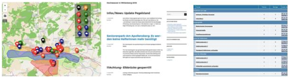 Figure 1: The three interfaces used to test helper decision-making.
Key Results: Accuracy vs. Intuition
The experiment yielded a striking paradox between what worked and what users liked.
1. Accuracy: The Forum Wins
The Forum group was the champion of "Sound Decision Making," with 64.3% identifying the correct station. Forums forced users to follow a logical path, ensuring they didn't skip critical "General Information" threads.
2. Efficiency: The Map Wins
The Map group was the fastest, taking only 218 seconds on average. Maps leverage the brain's ability to process visual spatial data instantly. However, map users often "over-prioritized" distance, choosing the closest station even if it wasn't the highest priority.
3. The Blog Failure
The Blog group was a disaster, with only 13.6% choosing correctly. Most users simply picked station 9 because it was at the top of the feed—ignoring the fact that the station was actually inaccessible due to a bridge closure mentioned further down.
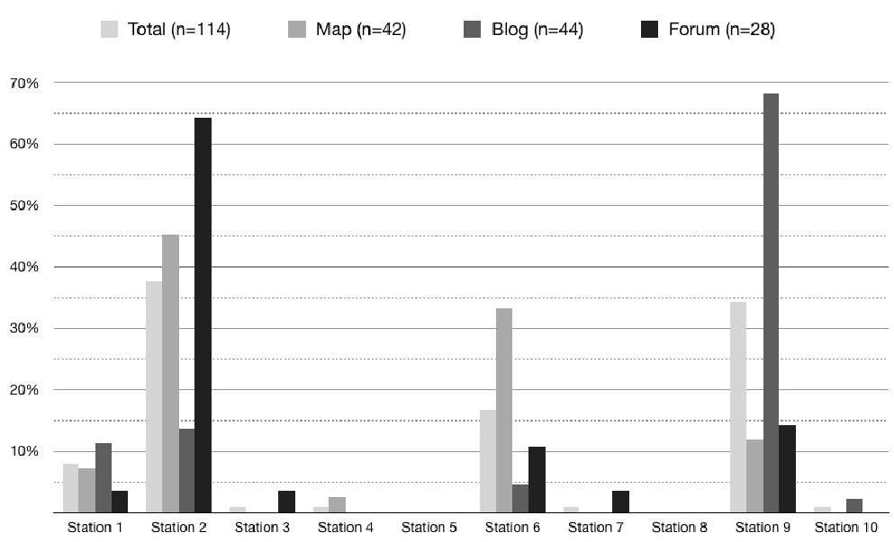 Figure 2: Distribution of choices across platforms. Station 2 was the only correct answer.
Critical Insights for Future Tech
The research provides several high-level takeaways for developers of Crisis Management Systems (CMS):
- Stop the Scroll: Chronological feeds are actively harmful in logistics. "Newest" does not equal "Best."
- The Distance Illusion: Maps are intuitive, but they can trick the brain into valuing geographic proximity over tactical necessity.
- Hybridization is Key: The "perfect" platform should combine the structured logic of a forum (for verification and filtering) with the visual speed of a map (for execution).
Conclusion & Future Outlook
While this study was limited to 114 participants (mostly students), its implications are profound. As Open Government moves toward more collaborative disaster response, we cannot rely on "off-the-shelf" social media. We need specialized interfaces that prioritize categorical importance over temporal recency.
Takeaway for Practitioners: If you are coordinating volunteers today, use a tool that allows for "pinned" urgent threads and categorical sub-groups. Don't let your most important instructions get "scrolled" into oblivion.