
Social Network and Spatial Semantics: Engineering Social Intelligence for Real-World Agents
Social Network and Spatial Semantics for Real-World Information Service
This paper proposes a framework for real-world information services by integrating Social Network Mining and Spatial Semantics into multi-agent systems. Using web-mining (co-occurrence analysis) and infrared sensors, the author extracts human relationships and defines a "Spatial Function Retrieval" (SFR) system to provide location-based services.
TL;DR
This research tackles the "context gap" in mobile and ubiquitous computing. By mining social networks from both the web and physical sensor data, and formalizing the "purpose" of physical spaces (spatial semantics), the paper enables multi-agent systems to provide more human-centric services, such as helping researchers find collaborators or finding a "place to rest" based on functional needs rather than just GPS tags.
Background & Motivation: Beyond Simple Coordinates
As we moved into the era of pervasive computing, sensors started generating massive amounts of behavioral data. However, the author argues that data without Social Knowledge is hollow. In our daily lives, we don't just move through coordinates; we move through social contexts. We speak softly in libraries (spatial semantics) and share information differently with a supervisor than with a peer (social relations).
The motivation here is to bridge the gap between "location-aware" systems and "social-aware" agents.
Methodology Part 1: Mining the Human Web
The author identifies two primary ways to quantify social bonds:
1. Web-based Collaboration Mining
The system uses search engine hit counts for queries like "Person X and Person Y". By applying overlap coefficients, the system identifies the strength of a relationship.
- Classification: Using the C4.5 algorithm, the system classifies edges into four types: Coauthor, Lab, Proj (Project), and Conf (Conference).
- The Logic: If two names appear on the same page index, there is a high probability of a latent social link.
2. Physical Sensor Tracking
At the JSAI conferences, researchers used CoBIT (infrared ID emitters) to track who stood near whom.
- Co-location Algorithm: If two people are detected by the same sensor within 30 seconds, they are considered to have "met."
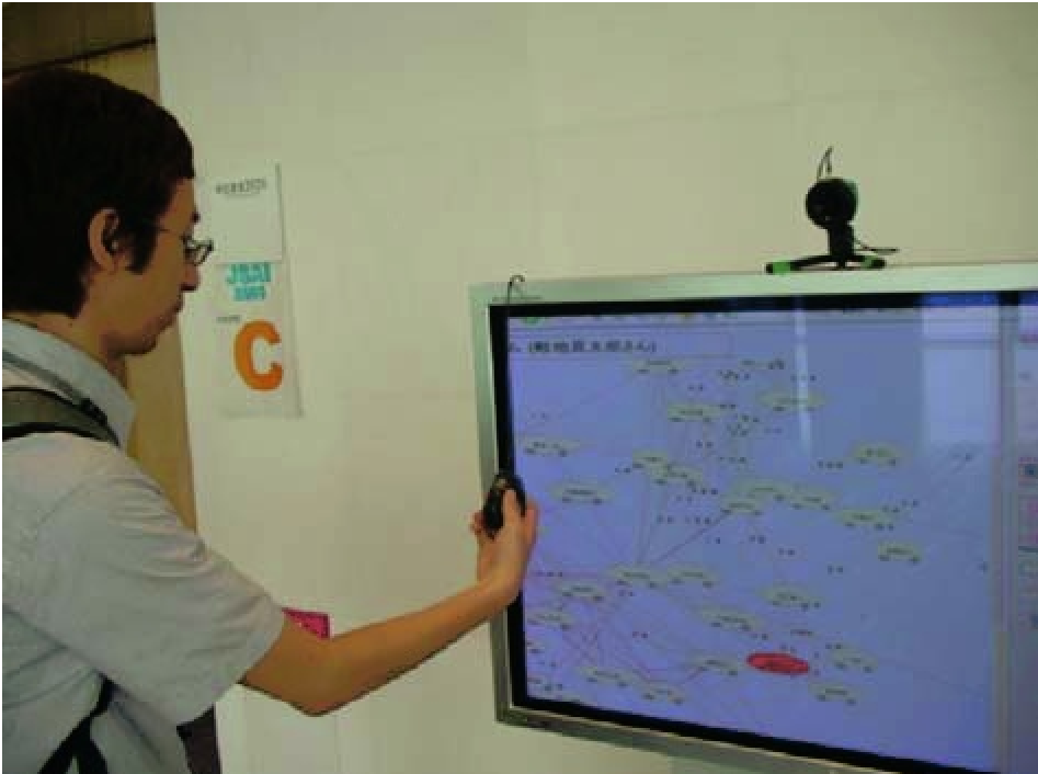 Figure 1: Visualization of the social network extracted from the JSAI community.
Methodology Part 2: Spatial Semantics (SFR)
The second pillar is the Spatial Function Retrieval (SFR) system. Instead of just labeling a room "Room 101," the author defines it using a triad:
(Space Region) × (User Type) × (Function Type)
Functions are categorized into:
- pprov: Physical provision (e.g., providing coffee).
- aprov: Abstract provision (e.g., providing permission or information).
- enable: Physical actions (e.g., "enabling" one to sit).
- permit: Social permissions (e.g., "permitting" one to smoke).
This allows the system to solve queries like "I am thirsty" by looking for any space that has the pprov: drink function, whether it's a cafe, a vending machine, or a lounge.
Experiments & Key Findings
The system was deployed during the JSAI2003 and JSAI2004 conferences.
Precision and Accuracy
The web mining approach showed high precision in identifying "Coauthor" and "Project" relationships, though "Laboratory" matches were harder to identify due to the diversity of university web page structures.
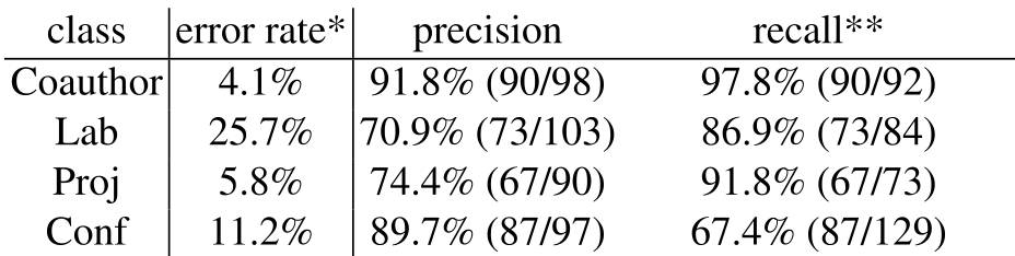 Table 1: Relationship classification error rates and precision.
The "Sensor vs. Web" Paradox
Interestingly, the researchers found that people with high "centrality" on the web (famous professors) were often at the "periphery" of the physical sensor network. Why? Highly cited experts often only visited the conference for a short time, whereas young researchers and students formed dense clusters in the physical space.
Critical Insight & Future Outlook
Takeaway: This work is a precursor to modern "Digital Twins" and "Knowledge Graphs." It proves that for an AI agent to be useful, it must understand the affordances of a space and the topology of the user's social circle.
Limitations:
- The sensor approach had very low recall (only 2.8% to 16.3%), showing that much of human interaction happens in the "blind spots" of sensor infrastructure.
- The classification rules for spatial functions were manually defined; future work could use automated ontology learning.
Conclusion: Matsuo's work provides a foundational look at how we can architect "Social Intelligence" into our devices. By mapping the world not just by meters and miles, but by relationships and functions, we create multi-agent systems that finally understand the "context" of human behavior.