
Social Reverse Geocoding: Beyond Coordinates to Human Perception
Social reverse geocoding studies: describing city images using geotagged social tagging
This paper introduces Social Reverse Geocoding (SRG), a novel method that converts GPS coordinates into human-centric semantic labels using geotagged social media tags. By leveraging user-generated data, SRG provides highly descriptive geographical information that outperforms traditional administrative street addresses in location recognition and urban navigation tasks.
TL;DR
Existing GPS systems translate coordinates into street addresses, but humans think in landmarks and "neighborhood vibes." This paper proposes Social Reverse Geocoding (SRG), a system that replaces dry administrative labels with vibrant, user-generated social tags. The result? A navigation experience where users find locations significantly faster because the map finally speaks the same language as their mental models.
The Cognitive Gap in Modern Maps
Why do we get lost despite having high-precision GPS? The problem is Geographic Cognitive Dissonance.
Traditional GIS (Geographic Information Systems) operates on a hierarchy of districts, streets, and numbers. However, urban dwellers navigate using an "image of the city"—a collection of landmarks, social hubs, and popular names. For example, in Tokyo, everyone knows where "Shibuya 109" is, but very few residents recognize its official address, "Dogenzaka." When a mobile app shows the latter, the user's cognitive load spikes as they try to reconcile the official data with their mental map.
Methodology: Socially-Aware Mapping
SRG flips the script by harvesting the millions of geotagged objects shared on social networks daily.
- Data Aggregation: The system collects geotagged social tagging data associated with specific coordinates.
- Semantic Overlay: Instead of querying a government database for a street name, SRG queries a social database for the most frequent and "identifiable" tags for that area.
- Cognitive Alignment: By using these tags, the system creates a "Zoomable Social Map" that reflects human perception rather than legal boundaries.
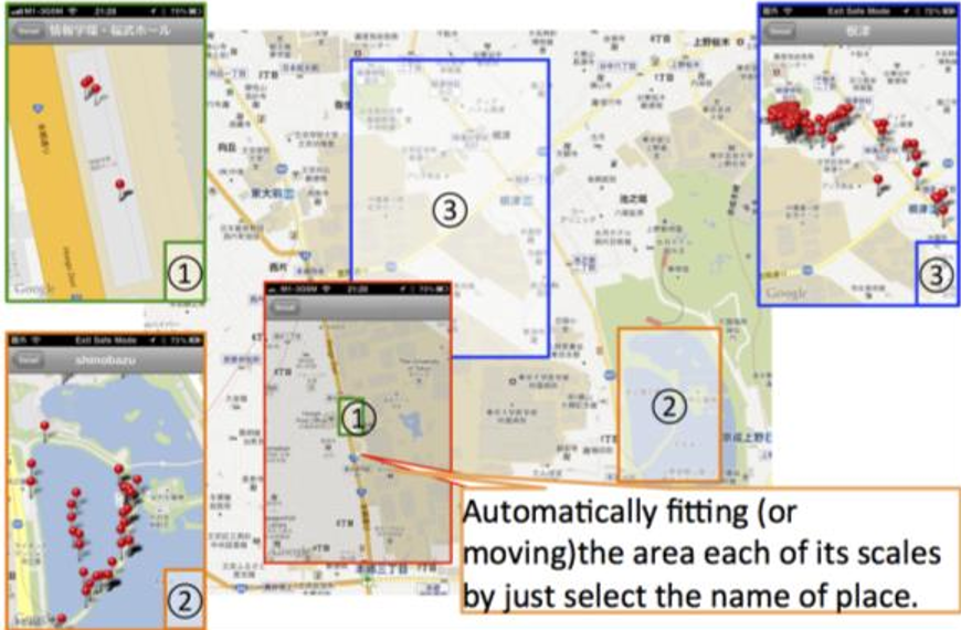 Figure 1: The architecture allows users to define city areas through SRG labels, resulting in a UI that requires less manual input (keyboard/multi-touch) to find relevant places.
Experimental Evidence: SRG vs. Administrative Addresses
The effectiveness of SRG was tested in the dense Shibuya district of Tokyo. The results were starkly one-sided in favor of social tagging.
- Recognition Delta: For the landmark Shibuya 109, 8 out of 8 participants recognized it via the "Shibuya" SRG tag, while 0 could identify it by its "Dogenzaka" address.
- Intuition vs. Reality: The Aoyama University test provided a fascinating insight; most subjects identified it with the "Aoyama" label despite it being administratively located in "Shibuya."
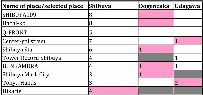 Table: Comparison of user recognition between SRG labels and administrative addresses (Pink cells indicate official addresses).
The data suggests that residents define city areas through SRG significantly "closer" to reality than street addresses do. The user preference ratio of 7:1 highlights a massive opportunity for LBS developers to improve usability by incorporating social metadata.
Critical Analysis & Conclusion
Takeaway
The genius of SRG is not in the complexity of its algorithm, but in its Inductive Bias toward human psychology. It acknowledges that geography is as much a social construct as it is a physical one. By aligning digital maps with the "cognitive maps" of users, we can create more seamless, keyboard-less mobile interfaces.
Limitations
While powerful, SRG is heavily dependent on the density of social media activity. In rural areas or developing regions with low social tagging frequency, the system would likely revert to traditional (and less effective) administrative geocoding. Furthermore, social tags are temporal; a trendy neighborhood name today might change in five years, requiring constant data refreshing.
Future Outlook
As we move toward Augmented Reality (AR) navigation, SRG becomes even more critical. An AR overlay showing "Shibuya Center-gai" is far more useful than one showing "Udagawa-cho." Future research should explore how to filter "noise" in social tags to ensure that the most universally recognized labels are prioritized.