
The Geography of Guilt: Bridging Social and Spatial Distances in Criminal Networks
Understanding the link between social and spatial distance in the crime world
This paper investigates the correlation between social distance in co-offending networks and spatial distance in criminal activity spaces. Using real-world crime data from British Columbia, the authors propose a framework to extract social profiles and reconstruct spatial "nodes" to prove that offenders who are socially closer are also spatially closer.
TL;DR
Does your social circle dictate where you commit crimes? This research confirms it does. By analyzing 4.4 million police records, researchers found a definitive "Social-Spatial Link": offenders who are socially connected in a network live closer to one another, share more frequent activity locations, and operate within a more concentrated geographic area than those socially distant.
Positioning: This work acts as a bridge between Environmental Criminology and Social Network Analysis (SNA), providing empirical evidence for a phenomenon that classic Crime Pattern Theory largely ignored: social influence on spatial choice.
Problem & Motivation: The Gap in Crime Pattern Theory
Classic criminology assumes offenders act within their Activity Space—the familiar routes between home, work, and social hubs. While intuitive, this "individualistic" view fails to explain why an offender might suddenly strike in an unfamiliar neighborhood.
The authors' insight is that co-offending networks function as information-sharing hubs. Just as friends recommend movies, co-offenders "recommend" crime locations. However, quantifying this relationship requires reconciling two very different data types: abstract network graphs and physical GPS coordinates.
Methodology: Mapping the Social-Spatial Nexus
The researchers developed a three-step workflow to synchronize social and spatial data:
1. Defining Social Classes
Offender pairs (dyads) were partitioned based on their network proximity:
- Connected (): Direct partners in a crime.
- Close (): "Friends of friends" (2-hop distance).
- Distant (): No direct or near-linkage.
2. Spatial Profile Reconstruction
Since police rarely have 24/7 GPS data, the authors used Activity Nodes. These are derived by clustering crime locations and intersection points of travel paths.

3. Measuring Spatial Similarity
The study looks at three metrics:
- Home Location Distance: Physical distance between residences.
- Number of Common Nodes: Overlap in frequent activity centers.
- Common Activity Space: The area of a triangle formed by the offenders' homes and their shared crime nodes.
Experiments & Results: Evidence of Proximity
Testing across multiple regions (Surrey, Prince George, Coquitlam), the results were remarkably consistent.
Key Findings:
- Residential Clustering: In the city of Surrey, direct co-offenders lived an average of 7.5km apart, whereas socially distant offenders lived 12.9km apart.
- Shared Knowledge: Socially close offenders shared significantly more "nodes" (activity locations), supporting the theory that criminals introduce their contacts to new opportunities.
- Area Expansion: As social distance increases, the "Common Activity Space" triangle expands significantly, suggesting that social bonds keep criminal activity geographically focused.
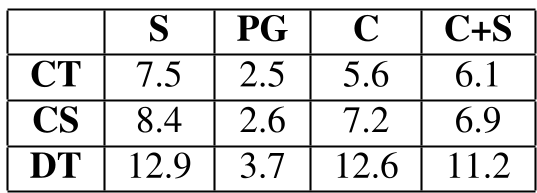 In all tested regions, the direct correlation remains: Social Closeness = Spatial Proximity.
Critical Analysis & Conclusion
Takeaway
The study successfully quantifies the "Social-Spatial Link." For law enforcement, this means that if an offender is spotted in a new area, their social network "neighbors" are the most likely candidates for future activity in that same area.
Limitations & Future Work
The authors acknowledge a major hurdle: The "Dark Figure" of Crime. The network only includes offenders who were caught. Many latent social links remain invisible to police. Furthermore, the model could be enhanced by incorporating Modus Operandi (MO)—analyzing if socially close offenders also use similar technical methods for committing crimes.
Ultimately, this work moves us closer to a "Unified Field Theory" of crime, where the "Where" is inextricably linked to the "Who."