
Social Street View: Blending Immersive Maps with the Social Pulse of the City
Social street view: blending immersive street views with geo-tagged social media
This paper introduces Social Street View (SSV), a cross-platform system that integrates geo-tagged social media (e.g., Instagram) into immersive 3D environments like Google Street View. By utilizing WebGL and WebVR, it achieves a seamless "Mixed Reality" experience, rendering social content as virtual billboards aligned with real-world building geometry.
TL;DR
Social Street View (SSV) is a pioneering Mixed Reality system that takes geo-tagged social media out of the 2D scrolling feed and places it directly onto the 3D walls of our cities. By fusing Google Street View's panoramic data with real-time social data, it creates an immersive experience where you can see what people ate, saw, or said at a specific street corner—all rendered in real-time at 60 FPS.
Problem & Motivation: Beyond the Scroll
We live in a world of "spatial data" trapped in "linear interfaces." When you look at an Instagram post of a famous museum, you see the photo, but you lose the context of the street it was taken on. While 2D maps (like NewsStand or Panoramio) helped, they lack the "presence" of being there.
The technical challenge is twofold:
- Scale: Building 3D models of every city from scratch is too slow.
- Clutter: If you just "drop" thousands of photos into a 3D space, it becomes a chaotic mess that hides the very scenery you want to see.
Methodology: The "Aesthetic" Alignment
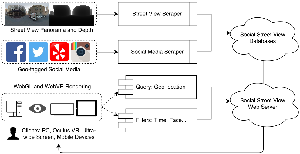
The core "magic" of SSV isn't just showing photos; it’s where and how it places them. The system uses a specialized scraper to pull not just images, but Depth Maps and Normal Maps from street view services.
1. Geometric Registration
Instead of floating images in mid-air, the system uses the Normal Map to calculate the orientation of building facades. It then "sticks" the social media photos onto these walls like virtual billboards.
2. Intelligent Layout via Poisson-disk Sampling
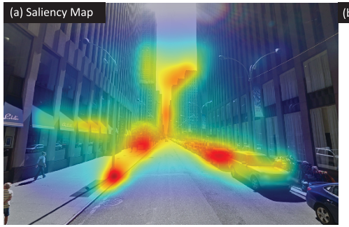
To solve the clutter problem, the authors avoided random placement. They employed Maximal Poisson-disk Sampling. This ensures that no two photos are too close to each other, maintaining a minimum "safety distance." Furthermore, they used Saliency Metrics to ensure photos don't cover up important visual landmarks (like a unique architectural arch or a street sign).
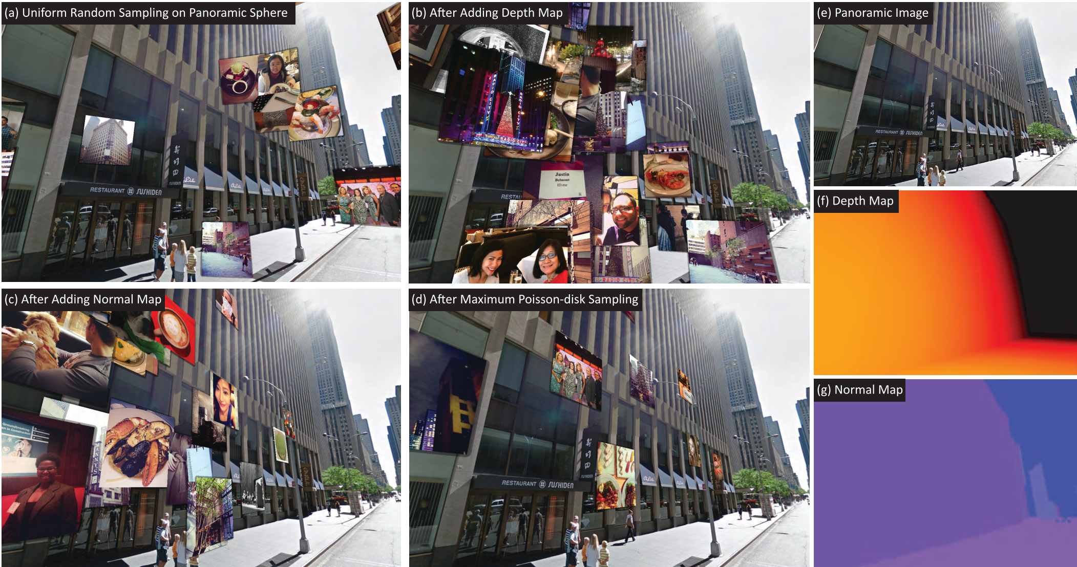 In the figure above, (a) shows the mess of random sampling, while (d) shows the clean, structured look of Poisson-disk placement.
Experiments: Performance at Scale
Running a 3D world in a browser is hard. SSV uses WebGL and WebVR to stay cross-platform.
- Speed: The system successfully hit 60 FPS even when rendering 100+ social media billboards simultaneously.
- Latency: By pre-fetching adjacent "panoramas," the system reduces the "jump" time between street locations to roughly 900ms.
- Saliency: Tests on 100 panoramas in Manhattan proved that their algorithm significantly reduced "visual noise," keeping the important parts of the street view visible.
Deep Insight: Why This Matters
The true value of Social Street View lies in "Contextual Storytelling." Imagine a tourist in Paris: instead of looking at a static map, they put on a VR headset and see "ghosts" of past travelers—photos of meals at a café, a sunset shot from the exact spot they are standing, or a celebrity sighting tag.
Use Cases:
- Democratized Tourism: "Crowd-sourced Kodak spots" where you see where others took the best photos.
- Business Advertising: Restaurants displaying real customer photos on their virtual storefront.
- Cultural Education: Seeing a city's holiday atmosphere (like the Spring Festival in China) through the eyes of locals.
Conclusion & Future Look
SSV is a brilliant example of how we can repurpose the "metadata" of the web to build the "Metaverse" without needing a trillion-dollar 3D scanning budget.
Limitations: The current system relies on "coarse" depth maps. As LIDAR data becomes more common in consumer maps, the alignment will become pixel-perfect. Future: Integrating real-time AI to filter out "junk" photos or privacy-sensitive faces will be the next step in making this a consumer reality.
For more details, check out the supplementary video at socialstreetview.com.