
Social Street View: Turning Static Maps into Live Social Experiences
Social street view: blending immersive street views with geo-tagged social media
Social Street View (SSV) is a mixed-reality system that integrates geo-tagged social media (e.g., Instagram) into immersive 3D maps like Google Street View. By utilizing WebGL and WebVR, it projects social content onto building geometries in a spatially and temporally coherent manner, achieving real-time performance (60 FPS) across various display platforms.
TL;DR
Social Street View (SSV) is a pioneering research project that bridges the gap between immersive 3D mapping and real-time social media. By blending Instagram posts directly into Google Street View panoramas using WebGL, it creates a "Mixed Reality" world where you can see what people ate at a specific restaurant or complained about on a specific street corner, all within their original 3D context.
Context: This work is a "SOTA UI/UX integration" that proves we can visualize massive amounts of crowd-sourced metadata without overwhelming the user or the hardware.
The "Context Gap" in Social Media
We live in a world where almost every photo we take is geo-tagged. Yet, when we browse social media, we are stuck scrolling through vertical feeds. When we look at maps, we see empty streets.
The authors realized that context is king. Seeing a photo of a meal is one thing; seeing that photo floating right next to the restaurant window in a 360-degree panorama is a completely different, more immersive experience. The challenge was: how do we place thousands of random photos into a 3D scene without it looking like a cluttered mess?
Methodology: The Art of Aesthetic Placement
The core innovation of Social Street View isn't just "showing photos"—it's the layout algorithm. The system uses three distinct layers of intelligence to place social media:
- Geometric Alignment: Using depth maps and normal maps (extracted from Street View data), the system identifies flat surfaces like building walls. Photos are then rotated to lie flat against these walls, making them look like digital billboards rather than floating icons.
- Visual Comfort (Poisson-disk Sampling): To prevent photos from overlapping, the system uses "dart-throwing" algorithms. This ensures a healthy distance between images, maintaining a clean visual field.
- Saliency Awareness: The system evaluates "salient" regions—areas where the human eye naturally focuses (like street signs or landmarks). It tries to place social media in "low-saliency" areas to avoid blocking the most important parts of the map.
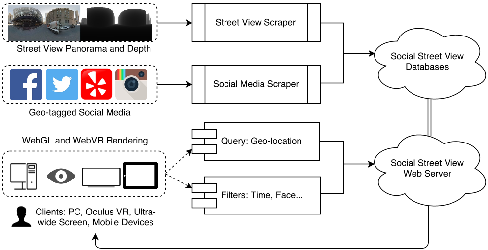 Figure 1: The architecture of Social Street View, from scraping to WebGL rendering.
Performance: Real-Time across All Devices
One of the most impressive feats is that this is built for the Web. Using WebGL and Three.js, SSV runs at 60 Frames Per Second on standard desktops.
- Latency: By pre-fetching nearby panorama data, the "jumping" sensation between street locations is minimized.
- Scalability: Whether on a smartphone, an Oculus Rift (HMD), or a room-sized projector array, the system scales the resolution and layout dynamically.
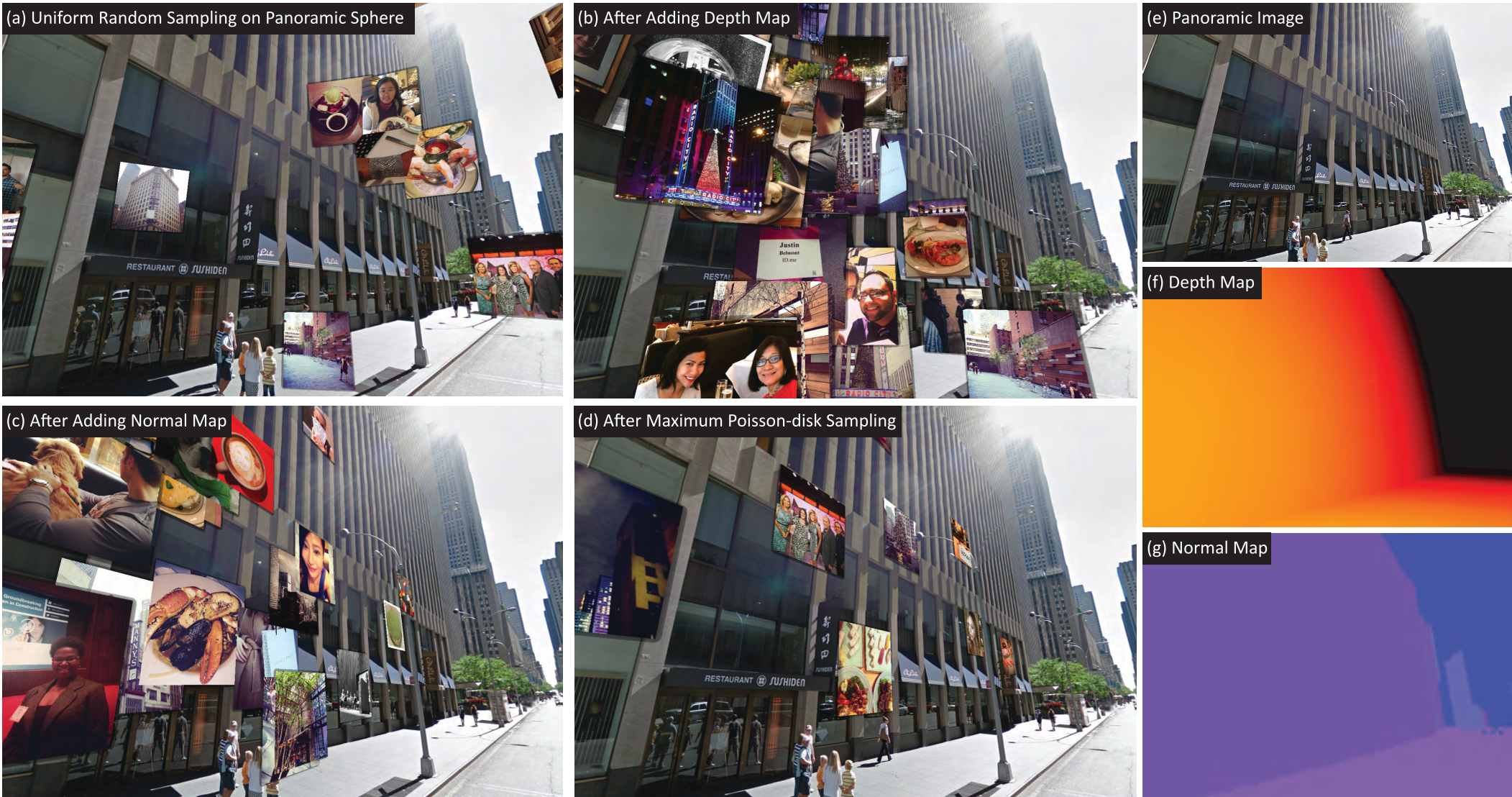 Figure 2: Evolution of the layout: (a) Random (messy) vs. (d) Optimized with Poisson-disk and Normal maps (clean).
Use Cases: Why This Matters
The research highlights several "killer apps" for this technology:
- Crowd-sourced Tourism: Preview a hiking trail through the photos of people who were there yesterday.
- Hyper-Local Advertising: Restaurants can show off their "Best Hits" (most liked photos of dishes) right on their virtual storefront.
- Cultural Preservation: Seeing how people celebrate festivals (like Chinese New Year) in the exact locations where they occur.
Critical Analysis & Conclusion
Takeaway: Social Street View represents a significant shift from "Social Media as a Feed" to "Social Media as a Layer of Reality."
Limitations: The system currently relies on "coarse" depth maps. As 3D reconstruction (like NeRFs or Gaussian Splatting) becomes more accurate, the alignment of social media will become even more seamless. Furthermore, privacy remains a concern; as social media becomes more "spatial," the ability to precisely locate users increases.
Ultimately, SSV is a glimpse into a future where our digital memories are no longer trapped in our phones, but are part of the very fabric of the virtual world we explore.