
Soter: Transforming Smart Bracelets from Simple Trackers into Intelligent Guardians
Soter: Smart Bracelets for Children's Safety
This paper introduces Soter, an intelligent safeguard system utilizing smart bracelets and cloud-based data mining to protect children. By analyzing location histories through the SRC (Integrated K-means-Laplacian) clustering and CloSpan algorithms, Soter identifies "safe regions" and "safe routes" to detect potential dangers in real-time.
TL;DR
The safety of children is a global priority, yet most existing GPS trackers are "dumb" and "energy-hungry." The Soter system, developed by researchers from West Virginia University and FIU in collaboration with Qihoo, introduces a data mining framework that learns a child's Safe Regions and Safe Routes. By identifying deviations from these patterns, the system provides proactive alerts to parents while extending battery life significantly via a hybrid GPS/GSM positioning strategy.
Problem & Motivation: The Gap Between Location and Safety
Every year, hundreds of thousands of children go missing globally. While GPS technology is mature, its application in children's safety faces two critical barriers:
- High Cognitive Load on Parents: Standard trackers require parents to check maps constantly. They don't distinguish between "at school" (safe) and "at a strange construction site" (danger).
- The Energy Paradox: Reliable tracking requires high-frequency GPS, but high-frequency GPS kills wearable batteries within hours, often leaving the child unprotected when most needed.
The authors’ core insight is that children’s lives are highly regular. By mining these regularities, we can build a system that only screams for attention when something is truly abnormal.
Methodology: Mining Life Patterns
Soter’s intelligence resides in how it processes "Location Histories" into "Life Patterns."
1. Safe Region Clustering (SRC)
Instead of simple distance-based clustering, Soter uses Integrated K-means-Laplacian (KL) Clustering. This method doesn't just look at where a child sits; it analyzes the relationship between stay points (e.g., how often they move from point A to point B).
- Stay Points: Temporal clusters where a child spends significant time (e.g., classroom, playground).
- Graph Logic: It constructs a weighted directed graph where edges represent the probability of moving between points and the duration of stay.
2. Safe Route Mining
Using the CloSpan algorithm, Soter identifies "closed frequent sequential patterns." If a child usually takes Path A to school during weekdays, and suddenly appears on Path B, the system calculates a "strange route" alert.
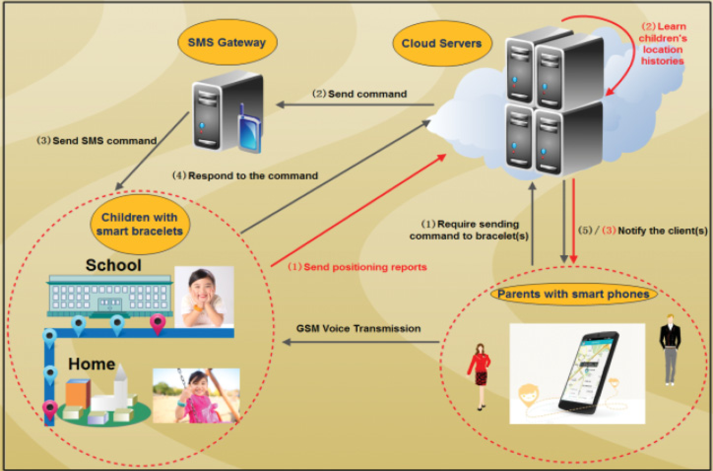 Figure 1: Overview of the Soter cloud-based safeguard ecosystem.
Energy-Efficient Positioning: "GPS-on-Demand"
To solve the battery drain, Soter implements an adaptive strategy:
- Safe Zone Mode: If the child is within a known "Safe Region" (detected via cheap GSM CellIDs), the power-hungry GPS is switched off.
- Status-Triggered GPS: GPS is only activated if the CellID changes unexpectedly or if the cloud detects the child might be entering a "strange region."
Experimental Results
The system was tested on 800 volunteers across China, processing over 7 million location points.
Positioning Performance Comparison
| Approach | GPS Usage | Median Error | Battery Life |
|---|---|---|---|
| Pure GPS | 100% | 53.5m | 4.3h |
| Pure GSM | 0% | 436.0m | 35.4h |
| Soter (Hybrid) | 9.5% | 87.5m | 27.8h |
As shown in the table, Soter provides a bridge—offering near-GPS accuracy for a battery lifespan that covers a child's entire school day and more.
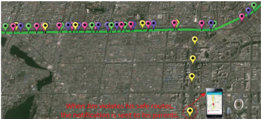 Figure 2: Comparisons of learned safe routes vs. current trajectories (Google Earth visualization).
Critical Insight & Conclusion
The true value of Soter lies in its semantic understanding of movement. It moves the needle from "Where is the child?" to "Is the child's behavior normal?"
Limitations: The authors acknowledge that indoor localization remains a challenge (where GPS fails) and that future versions must integrate Wi-Fi and G-Sensors (accelerometers) to refine indoor tracking.
In conclusion, Soter represents a successful marriage of spatiotemporal data mining and low-power IoT hardware, proving that data intelligence can effectively solve physical-world safety constraints.