
Leveraging Web Mapping Services: A New Paradigm for Asset-Light Spatial Crowdsourcing
Spatial crowdsourcing based on Web mapping services
The paper introduces a novel Spatial Crowdsourcing (SC) system model that leverages third-party Web Mapping Services (WMS) like Google or Bing Maps via APIs. This approach eliminates the need for platforms to maintain costly local road network data and real-time traffic info, achieving significant efficiency through optimized pruning and route sharing algorithms.
TL;DR
Building a spatial crowdsourcing (SC) platform like Uber or Meituan usually requires massive investments in GIS data and traffic monitoring. This paper proposes a paradigm shift: instead of "owning" the map, platforms can "subscribe" to it via Web Mapping Services (WMS). By introducing clever pruning and route-sharing algorithms, the authors solve the dual challenges of high API costs and latency, making high-accuracy SC accessible even to resource-constrained startups.
The "Data Wall" for SC Startups
In the world of Spatial Crowdsourcing, the distance between a worker and a task is the "Golden Metric." While many academic models use Euclidean distance (as the crow flies), real-world efficiency depends on network distance (actual roads) and travel time (accounting for traffic).
The Problem:
- Resource Scarcity: Small platforms cannot afford to maintain global road networks or live traffic feeds.
- The API Trap: Using Google Maps or Bing APIs is easy but expensive. High-frequency queries for every worker-task pair leads to astronomical costs and slow response times.
- Privacy Concerns: Workers are often hesitant to share raw GPS coordinates with a platform.
The Proposed Architecture: Outsourcing the Intelligence
The authors propose a system where the SC platform acts as a middleman between participants and professional WMS providers (Google, Bing, etc.).
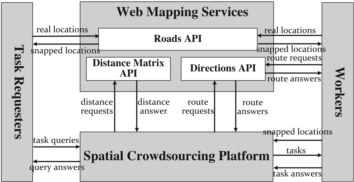
The workflow integrates three critical APIs:
- Roads API: Snaps GPS points to the nearest road. This adds a layer of privacy by "fuzzing" the exact location to a street-level coordinate.
- Distance Matrix API: Provides the cost (time/distance) for a matrix of origins and destinations.
- Directions API: Generates the exact path for the worker to follow.
Methodology: Making APIs Affordable
The core technical contribution lies in reducing the number of "Expensive Requests."
1. Two-Step Pruning for Distance Matrix
To avoid querying the distance for every possible worker-task pair, the system uses:
- Initial Pruning: Eliminates any task where the Euclidean distance exceeds the worker's service range (since
Network Distance >= Euclidean Distance). - Incremental Pruning: Based on Lemma 1, the platform ranks tasks by Euclidean distance and only queries the top- actual network distances. It uses the maximum retrieved network distance to prune remaining tasks whose minimum possible distance (Euclidean) is already worse than the current maximum.
2. Route Sharing via Optimal Sub-route Property
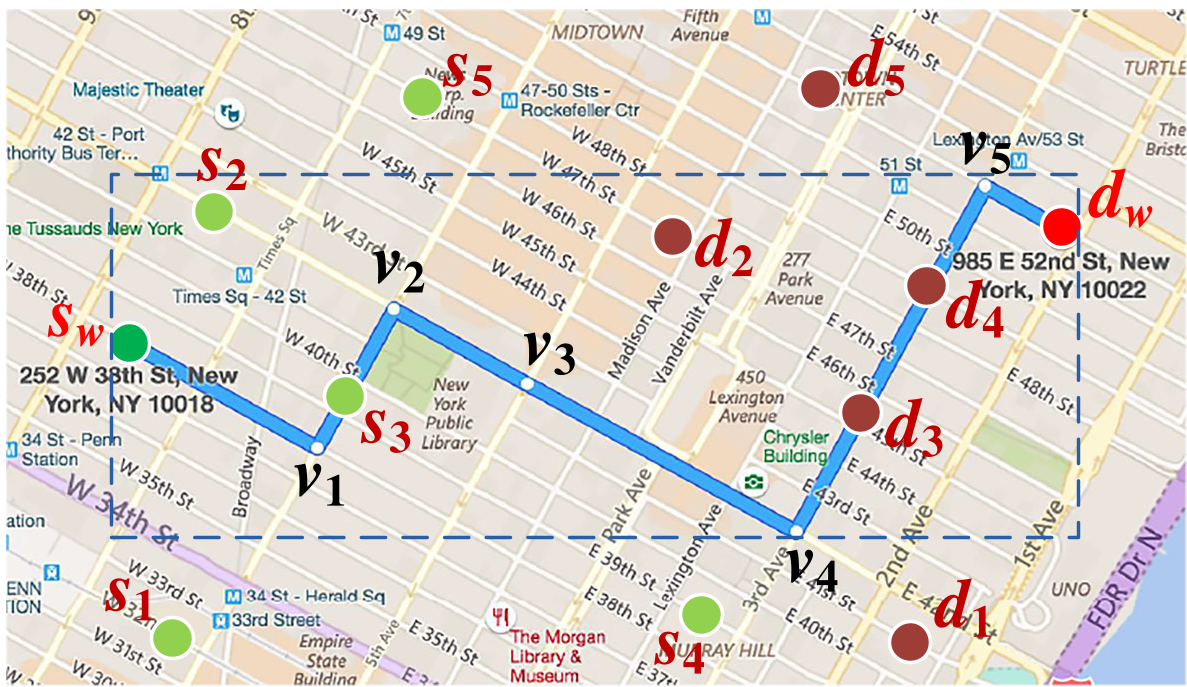
The authors leverage a fundamental property of shortest paths: any part of a shortest path is itself a shortest path.
In ride-sharing, if a passenger's pickup and drop-off points lie on a driver's existing route, the platform can assign the task without a new Directions API call. The paper describes a geometric check to verify if a point lies on a straight-line segment using the formula: .
Experimental Validation
The authors used real POI data from Minnesota and the California road network.
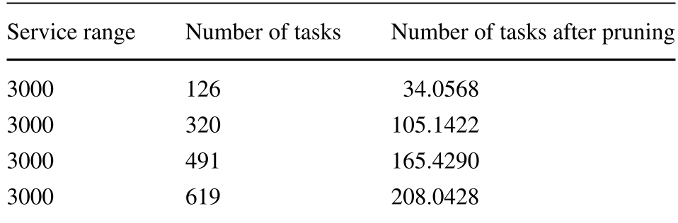
- Pruning Performance: The algorithm successfully pruned approximately 66% of tasks across varying scales, drastically cutting down on API calls.
- Service Range impact: Even with a generous 3000m service range, the pruning remained highly effective.
- Route Sharing: As the density of tasks increases, the efficiency of route sharing grows exponentially. With 200,000 paths, up to 60% of requests could be avoided.
Critical Insight & Conclusion
This paper bridges the gap between theoretical SC assignment and practical business implementation. By treating the Map as a Service (MaaS), it democratizes the ability to build sophisticated logistics and crowdsourcing apps.
Key Takeaways:
- Privacy as a Side Effect: Using "Snap-to-Road" APIs inadvertently provides a trusted third-party privacy layer.
- Geometry is Power: Simple Euclidean bounds remain the most effective tool for "pre-filtering" expensive network-based computations.
- Future Path: While this paper focuses on costs, future research should look at how the latency of these API calls affects real-time matching in highly dynamic markets like instant food delivery.