
Scaling Botanical Intelligence: A Data-Driven Map for Chinese Medicinal Plants
Regionalization of Chinese medicinal plants based on spatial data mining
This paper introduces a quantitative framework for the regionalization of Chinese medicinal plants using spatial data mining and GIS. By applying a spatial clustering algorithm based on neighborhood relations to the distribution data of over 100 genuine regional herbs, the authors successfully categorized mainland China into seven distinct ecological and botanical zones (Northeast, North, East, Southwest, South, Northwest, and Qinghai-Tibet).
TL;DR
Researchers have moved Traditional Chinese Medicine (TCM) regionalization from "best guesses" to quantitative science. By applying spatial clustering with neighborhood constraints to the distribution data of over 100 herbs, this study partitions China into seven distinct ecological zones, providing a rigorous blueprint for the production of "geo-authentic" (Daodi) medicinal plants.
Background: Why Tradition Needed Data
In TCM, the concept of "Geo-authenticity" (Daodi) suggests that the quality of a herb is inextricably linked to its specific geographical origin. However, determining where one medicinal region ends and another begins has historically been a qualitative art rather than a quantitative science. The challenge is multi-faceted: one must account for latitude, altitude, rainfall, and soil, while ensuring that the resulting regions are geographically contiguous and logically distinct.
Methodology: Beyond Simple K-Means
Most clustering algorithms (like standard K-means) only consider the distance in the attribute space. If you used standard K-means for plant regionalization, you might end up with "islands" of clusters scattered across the map.
To solve this, the authors utilized a Spatial Clustering Algorithm Based on Neighborhood Relation.
1. The Adjacency Constraint
The algorithm introduces a spatial adjacency matrix . An object is only assigned to a cluster if:
- It is the closest to the cluster center.
- Crucially, it has a neighborhood relationship (contiguity) with the existing members of that cluster.
2. Architecture of the Study
The process followed a hierarchical workflow:
- Data Construction: 160 genuine herbs were used to create m-dimensional vectors for each county.
- Initial Clustering: Generated 19 micro-clusters based on spatial and botanical similarity.
- Refinement: Used "Shortest Distance Priority" and geomorphological laws to merge these into 7 macro-regions.
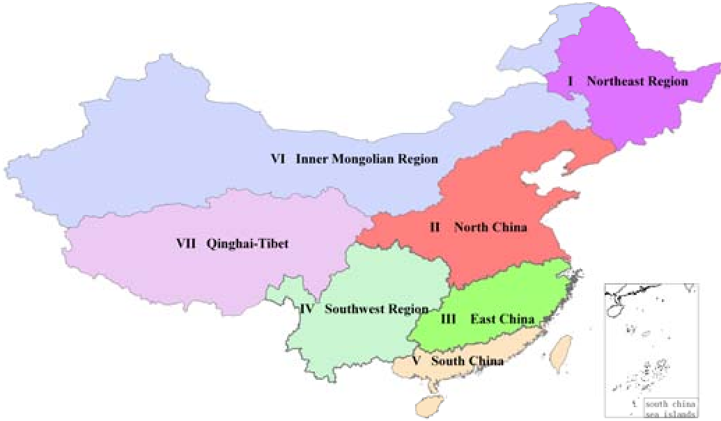 Fig 1: The resulting 7-zone spatial division pattern of Chinese medicinal plants.
The Seven Pillars of Chinese Medicinal Geography
The study identifies seven distinct zones, each with a unique "botanical signature":
- Region I (Northeast): Cool and humid. Home to Ginseng and Asarum.
- Region II (North): Warm-humid but dry spring. Accounts for over 50% of total production (Honeysuckle, Banlangen).
- Region III (East): Subtropical climate with dense river networks. Rich in aquatic herbs.
- Region VII (Qinghai-Tibet): High altitude (4,000m avg). Characterized by wild, cold-resistant species like Cordyceps and Snow Lotus.
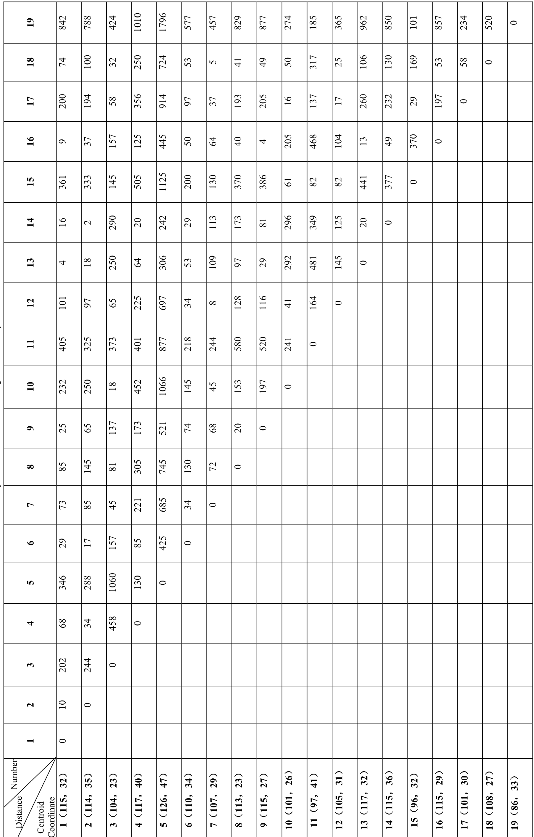 Table 1: Centroid coordinates and pairwise distances used for the regional combination phase.
Experimental Insight: The Impact of Geomorphology
The authors didn't just stop at the algorithm. They overlapped their results with China’s main river systems and terrain maps (Fig 3 in the paper). They found that geomorphological discrepancy laws (like the abrupt rise of the Qinghai-Tibet plateau) are the strongest predictors of species distribution, often overriding simple longitudinal gradients.
Critical Analysis
Why this works: By forcing neighborhood constraints into the clustering logic, the authors ensured that the results were "mappable" and practically useful for agricultural planning.
Limitations: The paper relies on county-level data, which might mask micro-climates within massive mountainous counties. Furthermore, while it quantifies current distribution, it does not yet model the temporal shift of these regions due to climate change—a critical next step for the industry.
Conclusion
This research is the first of its kind to quantitatively define the "Daodi" regions of China. It proves that the "intuition" of ancient herbalists has a measurable spatial logic. For the future of TCM, this data-driven regionalization is essential for standardizing quality and guiding large-scale sustainable cultivation.