
Enhancing Smart City Resilience: A Spatial Mobile Crowdsourcing Framework for Event Reporting
A Spatial Mobile Crowdsourcing Framework for Event Reporting
The paper introduces a comprehensive Spatial Mobile Crowdsourcing (SMCS) framework for photo-based event reporting. It integrates a sequential weighted bipartite graph matching algorithm for participant recruitment, a Deep Learning-based photo validation module, and an A-tree hierarchical data structure for redundancy elimination.
TL;DR
Researchers have developed a generic Spatial Mobile Crowdsourcing (SMCS) framework that leverages the ubiquity of smartphones and IoT devices (drones, CCTV) to report real-time events. By combining an Alpha-Fairness recruitment algorithm with Deep Learning-based image validation, the system ensures that high-quality, non-redundant visual data is delivered to requesters with minimal computational lag.
Background: Beyond Fixed Sensors
Modern urban planning relies heavily on fixed IoT sensors. However, these are static, expensive, and often ill-distributed for spontaneous events like fires or traffic accidents. Spatial Mobile Crowdsourcing (SMCS) offers a dynamic alternative, turning every citizen with a smartphone into a potential sensor. The challenge lies in recruitment (who should go where?) and data quality (how do we trust these photos?).
Methodology: The Three Pillars of Quality
The proposed framework architecture operates across four stages: Initiation, Announcement, Execution, and Handover. The core innovation lies in three specific modules:
1. Strategic Recruitment (The "Who")
The system treats recruitment as a Sequential Weighted Bipartite Graph Matching problem. It uses a "Score" function that balances a worker's history/expertise with their proximity to the event. To prevent "starvation" (where low-priority events never get covered), they implement α-fairness:
- (Sum Utility): Maximizes total system efficiency.
- (Proportional Fair): Balances efficiency and fairness.
- (Max-Min): Prioritizes the most neglected events.
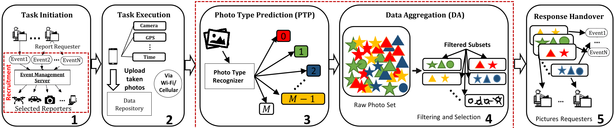
2. Photo-Type Prediction (The "What")
To eliminate "trash" data, the framework passes submissions through a CNN-based classifier. They tested ResNet-18 (fine-tuned and from scratch) against a custom CNN. This ensures that if a requester asks for "flood photos," the system automatically discards a photo of a cat taken at the same location.
3. A-Tree Data Aggregation (The "How Much")
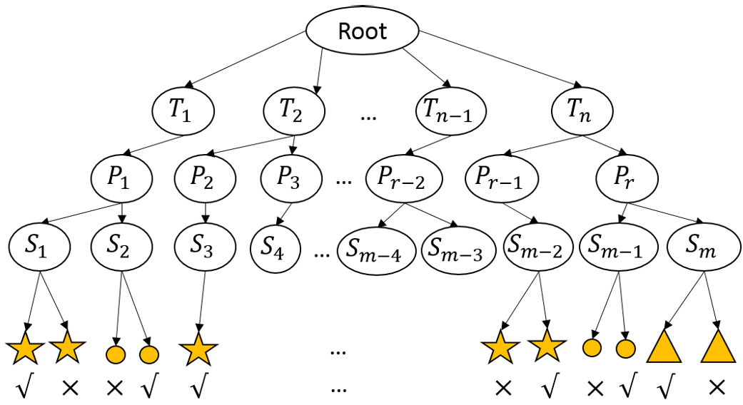
To avoid overloading the requester with 100 identical photos of the same pothole, an A-tree shape data structure clusters photos based on timestamps, GPS coordinates, and visual features (extracted via SIFT).
Experimental Analysis
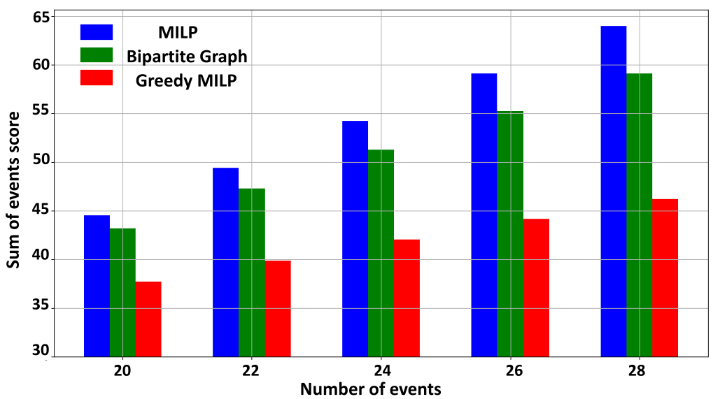
The researchers compared their bipartite matching algorithm against Mixed-Integer Linear Programming (MILP). While MILP is mathematically optimal, it is computationally expensive (NP-hard). The proposed algorithm achieved near-optimal scores while maintaining a constant, low running time, making it viable for real-time applications.
In the PTP phase, the ResNet-18 model trained from scratch achieved a staggering 95.14% accuracy, proving that deep learning can effectively act as a gatekeeper for crowdsourced content.
Critical Insight & Conclusion
The true value of this work lies in its hybrid nature. It doesn't just treat SMCS as a logistics problem (assignment) or a computer vision problem (classification); it recognizes that a viable system needs both.
Limitations: The current framework assumes workers are willing to provide location data, raising privacy concerns. Furthermore, it assumes a central authority manages rewards. Future Outlook: Integrating privacy-preserving techniques (like Differential Privacy) and decentralized incentive structures (Blockchain) could make this framework the standard for next-generation smart city response systems.
Main takeaway: By applying α-fairness to human mobility and CNNs to visual streams, we can create a self-organizing urban "nervous system."