
Secure Grid Indexing: Balancing Privacy and Scalability in Spatial Crowdsourcing
Spatial task management method for location privacy aware crowdsourcing
This paper introduces a spatial task management method for location-privacy-aware crowdsourcing using a secure grid-based index. By combining encrypted grid identifiers with local coordinate systems, the method achieves SOTA-level efficiency in processing geometry-based tasks while protecting participant anonymity.
TL;DR
The rise of "Human-in-the-loop" sensing (Spatial Crowdsourcing) brings a significant paradox: we need high-precision location data for task efficiency, but sharing that data endangers participant privacy. This paper presents a Secure Grid-based Task Management method that encrypts grid identifiers while maintaining local coordinates, resulting in a 70% speedup in data insertion compared to non-indexed systems while effectively thwarting location tracking attacks.
Problem & Motivation: The Geometry Privacy Paradox
In platforms like gMission or GeoCrowd, users act as mobile sensors. However, the transmission of sensing results (RM = {ID, Time, Location}) creates a honey pot for attackers.
Current solutions usually fall into two categories, both with flaws:
- Trusted Third Parties (TTP): Vulnerable to single-point-of-failure and internal breaches.
- Complex Spatial Indexing (e.g., SKD-trees): While secure, the overhead of managing height-balanced trees with encrypted keys becomes a bottleneck as the number of participants scales into the thousands.
The authors' insight is simple yet profound: Why encrypt the whole world when you can just hide the neighborhood? By shifting from global coordinate encryption to a localized grid-based coordinate system, they decouple the high-cost global search from the high-frequency local update.
Methodology: The Secure Grid Engine
The core innovation lies in the Grid-based Security Index. Instead of processing latitude and longitude, the system partitions the task area into discrete cells.
1. Two-Layer Obfuscation
- Grid ID Encryption: The global grid index is transformed using algorithms like RSA or DES. An attacker seeing
HXA2tkcannot map it back to a specific city block without the server-side key. - Relative Coordination: Within a cell, the system uses a local
(x, y)offset. This minimizes the data entropy exposed during result transmission.
2. Bulk Insertion Efficiency
When results arrive at the server, those falling within the same grid are processed as a "Bulk Data Set." This reduces the I/O cost significantly compared to individual point-by-point persistence in a standard database.
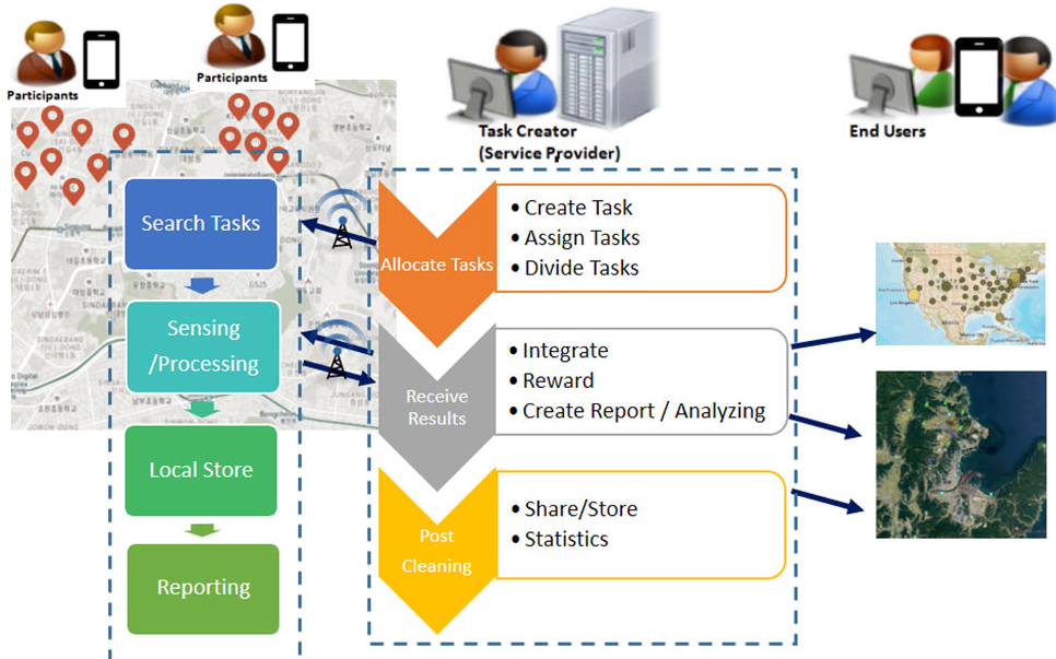 Figure 1: The proposed workflow for grid-based task registration and result propagation.
Experiments & Results
Using the Gowalla dataset, the team simulated a high-concurrency environment (100 to 1,000 active participants).
Significant Performance Gains
The proposed grid method outperformed the Secure KD-tree (the prior SOTA) by 20%. In comparison to a system with no spatial index, the insertion time was slashed by 70%. This proves that the computational savings from simpler grid math outweigh the costs of encryption.
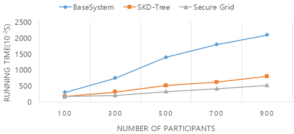 Figure 2: Performance results showing the grid-based method's superior scalability as the number of tasks increases.
Robustness Against Attacks
The authors specifically tested for "Center-of-Area" attacks, where an attacker tries to estimate a user’s location by calculating the centroid of their reported regions. As shown in the "normalized distance" tests, the grid-based method provided more "randomized" output than traditional optimal-cloaking methods, making it significantly harder for an attacker to pin down a participant's real location.
Critical Analysis & Conclusion
Takeaway
The shift from Tree-based to Grid-based spatial indices is a strategic move for mobile systems. Grids are naturally parallelizable and fit the "tiled" nature of modern map services (like OpenLayers used in this study).
Limitations
- Boundary Issues: The paper doesn't deeply address "boundary hopping," where a user moving between two grid cells might leak transition patterns.
- Static Grid Size: The efficiency is highly dependent on grid granularity. If the grid is too large, privacy drops; if too small, the index management overhead returns.
Future Work
The next frontier is applying this to non-rectangular tasks (e.g., following a specific trajectory) and integrating more lightweight encryption standards like Elliptic Curve Cryptography (ECC) to further reduce the energy drain on mobile devices.