
Social Sensing meets Earth Observation: The New Frontier of Geospatial Big Data
9229_Spatial Technology and Social Media in Remote Sensing A Survey.
This survey explores the synergistic integration of social media data with remote sensing (RS) and GIS spatial technologies. It identifies key methodologies for fusing heterogeneous big data sources and highlights SOTA achievements in disaster monitoring and urban analytics, where social media provides a 3.6x increase in localized real-time information.
TL;DR
This paper provides a comprehensive blueprint for integrating the "soft" data of social media (Twitter, Instagram, Foursquare) with the "hard" data of Remote Sensing (RS) and GIS. By treating citizens as mobile sensors, researchers can overcome the temporal gaps of satellite imagery, achieving real-time disaster response and high-granularity urban monitoring.
The "Blind Spot" of Traditional Remote Sensing
While satellite sensors provide unrivaled spatial coverage, they are often "blind" during the critical first hours of a disaster due to orbital constraints or cloud cover. Furthermore, RS data can capture that a building is flooded, but it cannot capture the human sentiment, the immediate needs of survivors, or the micro-level traffic disruptions. The bottleneck isn't a lack of data, but the lack of convergence between physical observations and social realities.
Methodology: Bridging the Gap through Localization
The core of the paper lies in the alignment of unstructured social media streams with structured spatial grids. The authors categorize this into three localization tiers:
- Detection of User Locations: Moving beyond unreliable IP geolocation to content-driven (mining tweets) and network-based (analyzing social proximity) estimation.
- Spatiotemporal Correlation: Exploiting periodic location patterns to predict human mobility and social interaction within a geographical radius.
- Data Fusion Framework: Assigning confidence weights to different sources (e.g., Satellite = 4, Road Closures = 3, Social Media = 1) to create a multi-layered "Common Operational Picture."

Key Performance Benchmarks
The survey highlights several success stories through quantitative evidence:
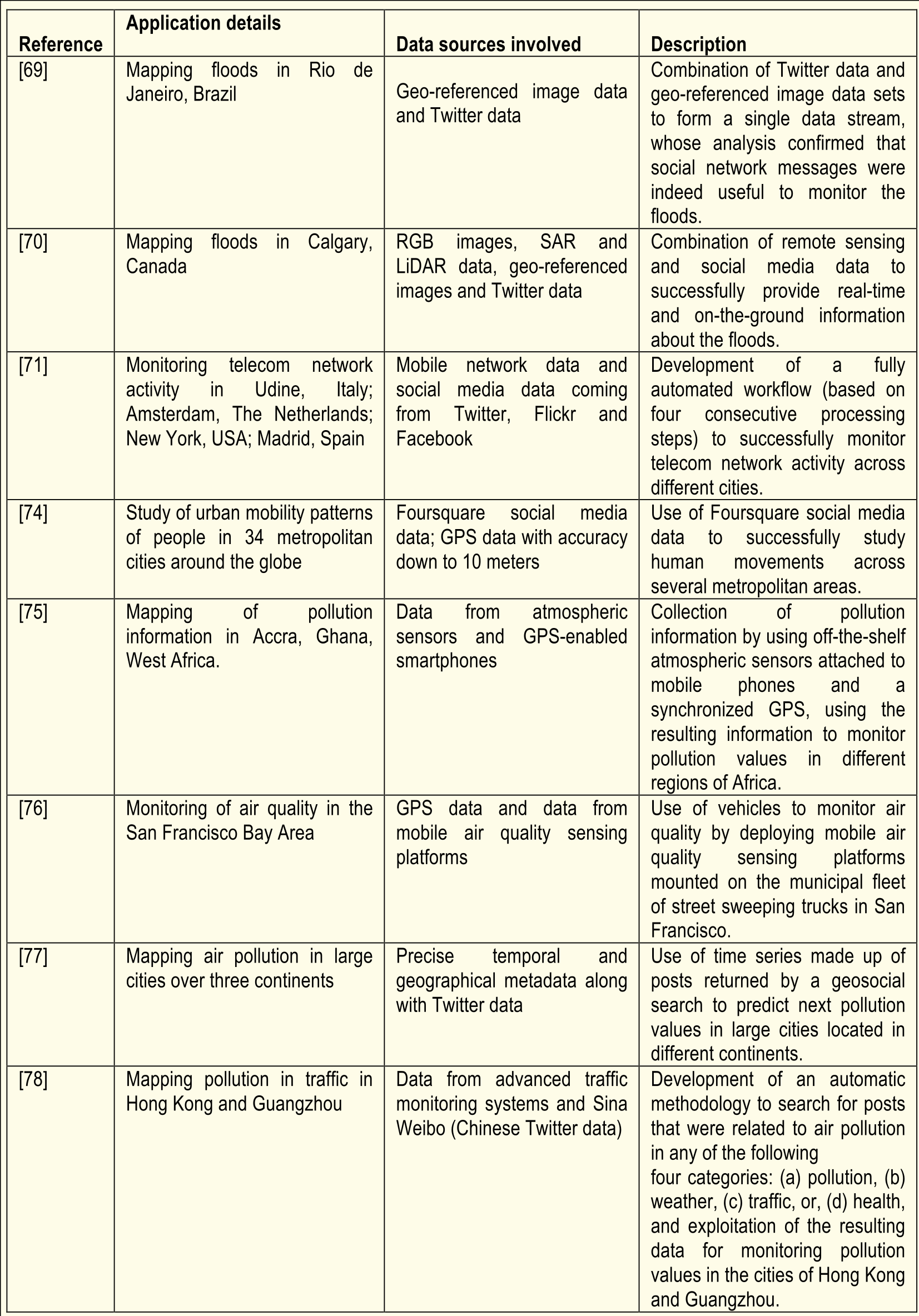
- Flood Monitoring (São Paulo): The study revealed a 3.6x increase in flood-related social media traffic within affected catchments compared to baseline periods, providing a real-time "human" flood map.
- Natural Disasters (Calgary): By fusing LiDAR, SAR, and Twitter data, researchers maintained situational awareness even when remote sensing coverage was limited. The volume of tweets corresponded linearly to the flood's progression.
- Environmental Monitoring: Leveraging sensors on street sweepers and smartphones to map air quality at a resolution impossible for satellites.
Critical Insight: The "Citizen Sensor" Paradigm
The most profound takeaway is the transition of the user from a consumer of maps to an active provider of geographic information. However, this is not without challenges:
- Trust and Veracity: How do we detect deception or "fake news" in social signals during a crisis?
- Privacy vs. Utility: As Chrome and other browsers tighten Geolocation API access, the industry must develop better "privacy-preserving" localization techniques.
- The Big Data Volume: The sheer velocity of 500 million daily tweets requires specialized Cloud Computing and High-Performance Computing (HPC) infrastructures to process in real-time.
Conclusion
The integration of social media and spatial technology is no longer an experimental niche—it is a fundamental transformation of how we observe our planet. Moving forward, the "Digital Earth" will not just be a collection of pixels, but a living, breathing model of human-environment interaction. The next step in this research involves the use of Graph Neural Networks to better understand the "Social-Spatial Proximity" and the deployment of federated learning to protect the privacy of "citizen sensors."