
SpatialRecruiter: Merging Query and Sensing for Optimal Urban Crowdsourcing
SpatialRecruiter: Maximizing Sensing Coverage in Selecting Workers for Spatial Crowdsourcing
This paper introduces SpatialRecruiter, a novel framework that integrates spatial crowdsourcing and mobile crowdsensing. It maximizes sensing area coverage by strategically selecting workers for location-based query tasks, achieving SOTA-level coverage efficiency on real-world taxi trajectory datasets.
TL;DR
SpatialRecruiter is a unified framework designed to solve the inefficiency of separate crowdsourcing systems. By treating the worker's journey to a query task as a valuable sensing trajectory, the system uses submodular optimization to maximize urban sensing coverage without increasing the total number of workers.
Background & Motivation: The "One-Shot" Intuition
In the current mobile landscape, we have two distinct silos:
- Spatial Crowdsourcing: Workers go to a specific point (e.g., to take a photo of a disaster site).
- Mobile Crowdsensing: Workers passively collect data (e.g., noise levels) along their daily routes.
The authors observed a missed opportunity: a worker traveling to fulfill a query task generates a trajectory that could satisfy sensing requirements. Why recruit two different sets of people when one can do both? The challenge lies in predicting coverage when workers move freely and don't disclose their private historical routes.
Methodology: The Core of SpatialRecruiter
The system architecture focuses on transforming spatial relationships into a selection problem.
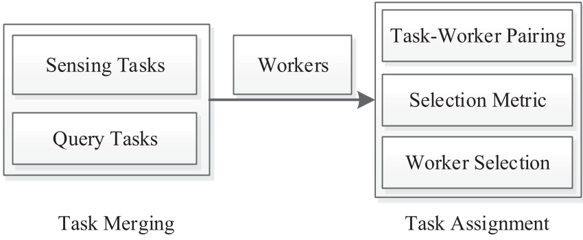
1. Estimating Potential Without History
To avoid privacy concerns related to historical GPS traces, the authors proposed two proxy functions:
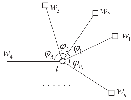
- Angle-Based (AGreedy): It models a worker’s potential path as a sector radiating from the target. If you pick workers with non-overlapping sectors, you maximize the chance that they cover different roads.
- Entropy-Based (EGreedy): This uses a chaos metric. By maximizing the spatial entropy of workers' starting positions around a task, you promote geographic diversity.
2. The Greedy Optimization
The paper proves that these estimation functions are monotone submodular. This is a critical academic insight because it guarantees that a simple greedy algorithm (picking the next best worker in each step) will achieve at least 63% (1 - 1/e) of the optimal performance—a significant result for an NP-hard problem.
Experiments: Real-World Evidence
The framework was tested using the T-drive dataset, containing trajectories of over 10,000 taxis in Beijing.
Key Insights from Results:
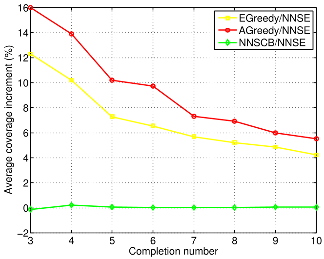
- Coverage Superiority: Both AGreedy and EGreedy outperformed the standard Nearest Neighbor (NNS) baseline. AGreedy (at a 45° potential angle) consistently provided the highest coverage increments.
- Efficiency Gains: The proposed methods showed a "bunching" effect in performance curves, consistently staying ~5% more efficient in terms of area covered per kilometer traveled compared to distance-only selection.
Critical Analysis & Takeaways
The brilliance of SpatialRecruiter lies in its simplicity—using geometry (angles/entropy) to solve a complex predictive problem without needing privacy-invasive historical data.
Limitations: The model assumes workers take relatively direct routes. In highly congested or complex urban grids, the "sector" assumption might fail. Furthermore, it doesn't yet account for specific worker "quality" or reliability.
Future Outlook: As cities become "smarter," frameworks like this will be essential. Imagine Uber or DoorDash drivers acting as real-time environmental sensors. SpatialRecruiter provides the mathematical foundation to make that transition efficient and privacy-aware.