
SSFS: Optimizing Crowdsourced Vision Databases via Spatial Diversity and Feature Saliency
SSFS: A Space-Saliency Fingerprint Selection Framework for Crowdsourcing Based Mobile Location Recognition
The paper introduces SSFS (Space-Saliency Fingerprint Selection), a framework for optimizing crowdsourced mobile location recognition databases. It combines a Self-adaptive Space Clustering (SSC) algorithm with a Salient Part Feature Detection (SPFD) algorithm to select high-quality image fingerprints, achieving SOTA-level precision while significantly reducing storage overhead.
TL;DR
As Mobile Visual Location Recognition (MVLR) shifts toward offline, on-device execution, the storage burden of massive crowdsourced databases has become a critical bottleneck. SSFS (Space-Saliency Fingerprint Selection) is a novel framework that intelligently prunes these databases. By combining an adaptive clustering method for spatial coverage and a hashing-based saliency detector to filter out "visual noise" (like moving cars or pedestrians), SSFS reduces data volume by 10% while actually improving search precision compared to unoptimized sets.
Background: The Hidden Cost of Crowdsourcing
Crowdsourcing has revolutionized how we build location databases, but it comes with two major headaches:
- Redundancy: Hundreds of users might take nearly identical photos of the same landmark.
- Disturbance: Real-world images are messy. Transient objects—pedestrians, vehicles, or shifting shadows—clutter the database and degrade matching accuracy.
For mobile devices, where storage and computational power are at a premium, we don't need more data; we need better data.
Methodology: The SSFS Architecture
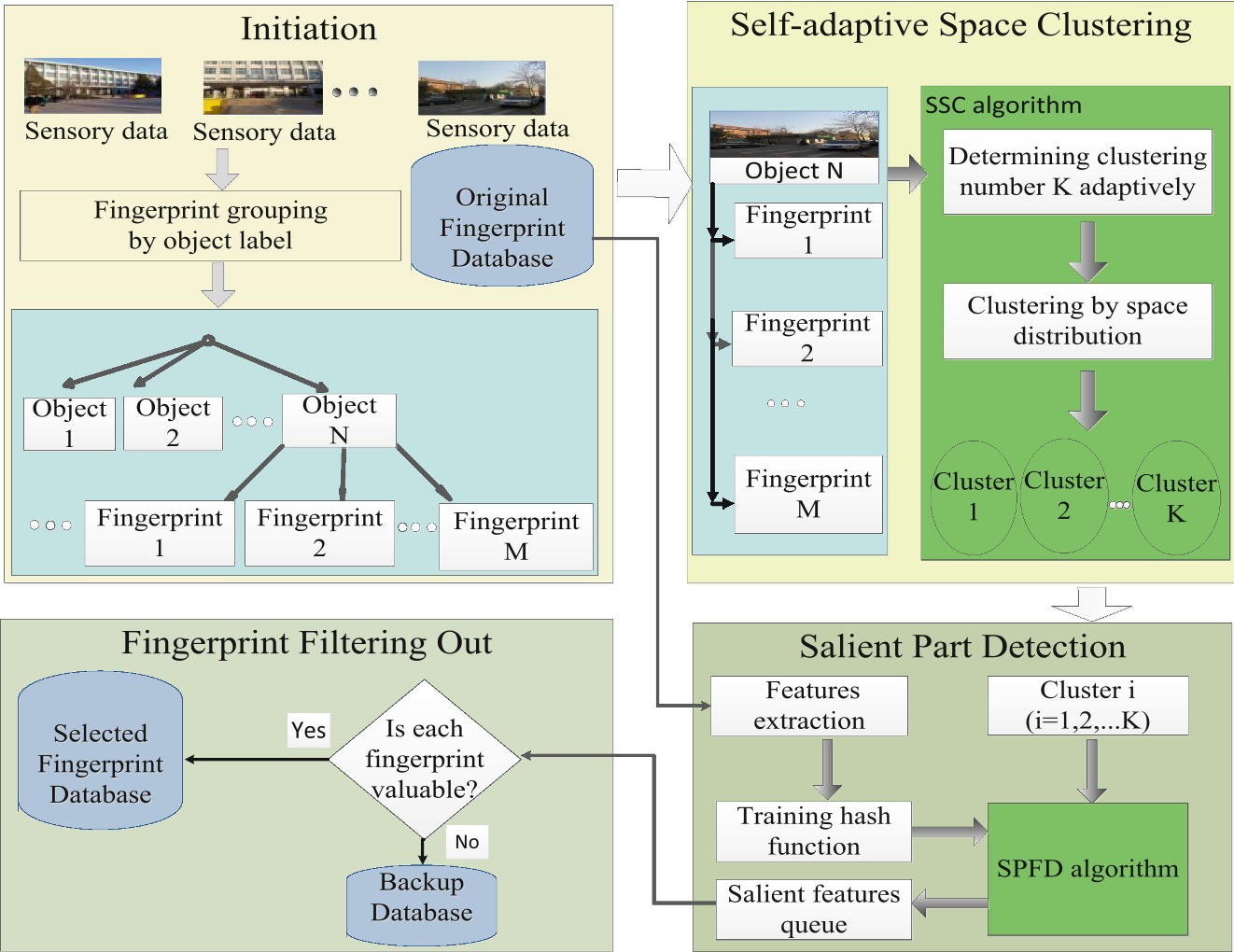
The authors propose a two-pronged strategy to ensure the selected fingerprints are both spatially representative and visually robust.
1. Self-adaptive Space Clustering (SSC)
Recognition fails if the database lack diversity in shooting angles. However, the "ideal" number of clusters depends on the object's complexity. SSC solves this by:
- Calculating the range of shooting angles () recorded by smartphone sensors.
- Adaptively determining the number of clusters () using a threshold logic.
- Applying K-means to ensure that the final selection covers all perspectives of a landmark.
2. Salient Part Feature Detection (SPFD)
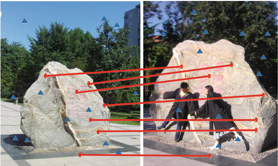
Once diversity is secured, how do we pick the "cleanest" image in a cluster? The insight here is Visual Saliency. Permanent structures (landmarks) appear in almost all photos of a location, whereas "noise" (like a student walking by) is transient.
- Feature Hashing: To keep it efficient, SURF features are converted into 80-bit binary hash codes using Spectral Hashing.
- Frequency Logic: SPFD counts "best matching pairs" across images. Features that appear frequently are tagged as "Salient Parts." Images with the highest count of these salient features are prioritized for the database.
Experiments & Results
The framework was tested on a dataset of 8,062 fingerprints from the BUPT campus, covering 162 unique objects.
Key Performance Metrics:
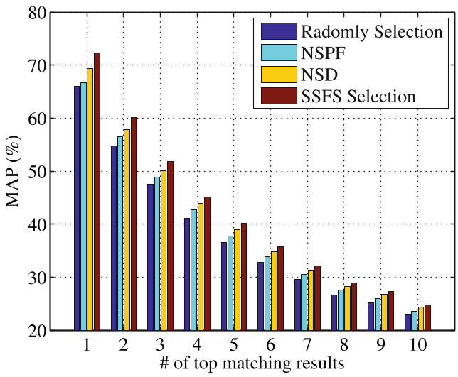
- Accuracy Gain: At 90% data retention, SSFS outperformed "Random Selection" and "Spatial-only Selection" by approximately 5% in Precision@N.
- Redundancy Compression: The study proved that 10% of data can be discarded without any drop in MAP (Mean Average Precision) compared to using the full 100% dataset.
Critical Insight & Conclusion
The brilliance of SSFS lies in its use of contextual metadata (sensors) to guide computer vision (saliency). By using azimuth data to "bucket" images before running expensive visual comparisons, the framework achieves a high degree of efficiency suitable for mobile ecosystems.
Takeaway: Future MVLR systems must treat data selection as a first-class citizen. As we move towards 2026 and beyond, the "intelligence" of a location service will be measured not by how much data it stores, but by how effectively it curates its knowledge base.
Limitations: The current angular threshold () is a heuristic. Future iterations might benefit from learned thresholds that vary based on the specific geometry of urban environments (e.g., narrow alleys vs. open squares).