
Stolperwege: Bridging the Physical and Digital in Holocaust Public History
Stolperwege: An App for a Digital Public History of the Holocaust
Stolperwege is a web-based ubiquitous computing framework designed for Digital Public History. It connects the "Stolpersteine" physical memorials with digital biographies, social networks of historical agents, and interactive 3D reconstructions to deepen public knowledge of the Holocaust.
TL;DR
Stolperwege ("Paths of Stumbling") is a sophisticated mobile framework that breathes digital life into the Stolpersteine (stumbling stones) art project. By combining semantic ontologies, historical map overlays, and 3D reconstructions, it allows users to trace the complex "live paths" of Nazism victims directly within their urban environment. It moves beyond static text to create a networked, multimodal history of the Holocaust.
The Problem: Fragmented History in a Digital Age
The Stolpersteine project by Gunter Demnig is a powerful physical intervention in cities across Europe. However, these stones often exist in isolation. Existing mobile apps typically offer little more than digital versions of the text engraved on the stones.
The academic challenge was two-fold:
- Network Connectivity: How do we show that these victims weren't just isolated individuals, but part of a vibrant social and familial fabric?
- Contextual Immersiveness: How can a contemporary user standing in a modern street visualize the historical buildings and paths that no longer exist?
Methodology: The Tech Stack Behind the Memory
The Stolperwege app isn't just a map; it is a knowledge-driven ecosystem.
1. Semantic Architecture
The backend uses OWLnotator to model biographies based on the TrendMiner Biography Ontology. This allows the system to perform entity linking—connecting a person not just to a location, but to other people, events, and organizations. This turns a list of names into a Social Network of History.
2. Spatio-Temporal Mapping
The app uses a dual-map approach. By aligning historical maps (e.g., from 1852) with modern OpenStreetMap data, users can literally see the "ghosts" of the city's past layout.
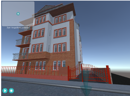 Figure: Aligned historical map of Frankfurt from 1852 integrated into the Stolperwege interface.
3. Interactive 3D Reconstructions
For buildings that were destroyed during or after the war, such as the "Ghettohaus" in Frankfurt, the team used Blender and Unity3D to create interactive models. These models are not just visual; they serve as containers for audio, video, and biographical data about the former inhabitants.
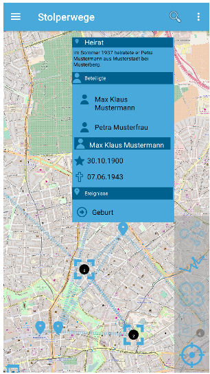 Figure: Interactive 3D animation of the historical "Ghettohaus", recreated from floor plans and old photographs.
Visualizing the "Road of Life"
One of the most striking features of Stolperwege is the visualization of biographical trajectories. Instead of a single pin on a map, the app uses polygons and lines to represent the StolperwegeElement. This visualizes the movement of individuals between cities (e.g., Amsterdam to Frankfurt), illustrating the forced migrations and life paths characteristic of the era.
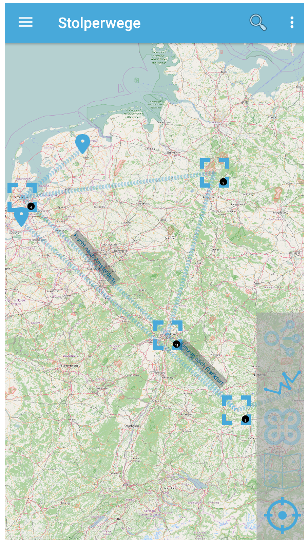 Figure: The "Road of Life" feature linking different geographical markers into a coherent biographical narrative.
Insights and Future Directions
Stolperwege represents a pivot in Ubiquitous Learning. It utilizes the "utility of history" by making it accessible via its primary source: the urban landscape itself.
Key Strengths:
- Multimodality: It successfully integrates text, maps, 3D, and audio.
- Collaboration: The project is built through interdisciplinary "practicums" involving both computer scientists and historians.
Limitations:
- Scalability: The creation of high-fidelity 3D models is "laborious," making it difficult to cover entire cities quickly.
- Data Sources: It relies heavily on the quality of available historical floor plans and photographs.
In conclusion, Stolperwege demonstrates that the future of public history lies in breaking the bounds of the "page" and the "screen," turning the city itself into an interactive, living archive.