
TERMS: Leveraging Crowdsourcing and Dynamic Thresholding for Real-Time Road Infrastructure Monitoring
Threshold Based Efficient Road Monitoring System Using Crowdsourcing Approach
2019-04-22
Summary
Problem
Method
Results
Takeaways
Abstract
This paper introduces TERMS (Threshold-Based Efficient Road Monitoring System), a crowdsourcing-driven platform designed to detect and categorize road anomalies like potholes and speed breakers using smartphone accelerometers and GPS. The system achieves a 90% detection accuracy for speed breakers and 85% for potholes by employing dynamic thresholding and a multi-user verification clustering technique.
## TL;DR
Good roads are the backbone of economic progress, yet monitoring them remains a manual, expensive task. This paper presents **TERMS**, a crowdsourcing framework that turns every smartphone into a road inspector. By analyzing accelerometer patterns and using "neighborhood consensus" (clustering), the system detects potholes and speed breakers with up to 90% accuracy, providing a live, severity-coded map of road conditions.
## The Problem: The High Cost of "Blind" Infrastructure
Road maintenance authorities often act too late. Statistical evidence suggests that spending $1 on timely maintenance can save $14 in later repairs. However, the bottleneck is **detection**. While smartphones offer a ubiquitous sensing platform, they introduce "noise":
- **Orientation Chaos**: A phone in a pocket vs. a phone on a dashboard provides different axis data.
- **Spurious Events**: A driver dropping their phone or hitting the brakes shouldn't be mapped as a pothole.
- **Static Data**: Maps often show potholes that were fixed months ago because there is no feedback loop for "repair verification."
## Methodology: Physics-Based Detection & Collective Intelligence
### 1. Solving the Orientation Puzzle
The core technical hurdle is reorientation. To ensure the system works regardless of whether the phone is in Portrait, Landscape, or Flat mode, the authors developed a reorientation mapping. This ensures that the **Z-axis** always represents vertical acceleration relative to the car, allowing for consistent thresholding.
### 2. The Signature of a Bump
The researchers identified unique vibration signatures for different obstacles:
- **Potholes**: Characterized by significant spikes in **X (Lateral) and Z (Vertical)** axes.
- **Speed Breakers**: Characterized by spikes in **Y (Longitudinal) and Z (Vertical)** axes.
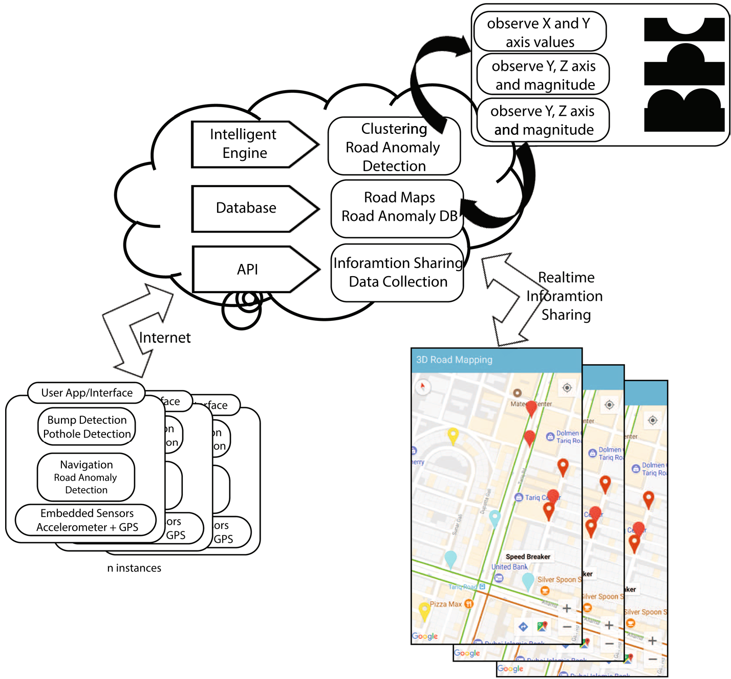
*Figure 1: The TERMS system architecture, showing the flow from mobile sensors to cloud-based filtering and map updating.*
### 3. Crowdsourcing as a Noise Filter
To prevent false positives, TERMS employs a **"Rule of Five."** A single report won't trigger a marker on the map. Instead, the cloud clusters data points within a 5-meter radius. Only when 5 independent samples confirm an anomaly does it appear on the global map. Conversely, if 5 users report a "smooth" transit over a previously marked spot, the marker is automatically removed, solving the "stale data" problem.
## Experimental Results: High-Fidelity Mapping
The system was validated using custom-built Arduino hardware (Mega 2560) as a "Ground Truth" baseline.
- **Accuracy**: 90% for speed breakers; 85% for potholes.
- **Severity Categorization**: By analyzing the amplitude of the Z-axis, the system colors markers (Red/Yellow/Cyan) to indicate the severity of the road damage.
- **Roughness Index**: Beyond discrete obstacles, the system calculates a general "Road Roughness Level," categorizing road segments as Acceptable or Unqualified.
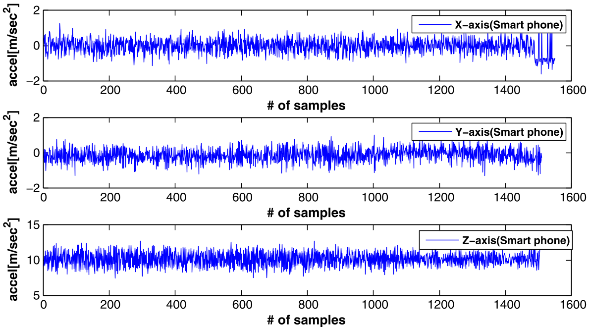
*Figure 2: Acceleration profiles on different road surfaces, from regular smooth roads (a) to road sections with speed bumps (c).*
## Critical Analysis & Conclusion
### Why It Works
The brilliance of TERMS lies not in complex AI, but in its **logical simplicity and the power of the crowd**. By using threshold-based algorithms, the system remains "lightweight" enough for real-time processing on low-end smartphones common in developing regions like Pakistan.
### Limitations
- **Speed Dependency**: The authors note that accuracy is best between 20-40 km/h. At very high speeds (over 80 km/h), the sampling rate and vibration intensity may lead to sensor saturation or missed events.
- **GPS Precision**: Reliance on standard GPS (5m error) necessitates the clustering algorithm, meaning small, closely spaced potholes might be merged into one.
### Future Outlook
The next evolution of this tech involves moving toward **AI-driven dynamic thresholds** that adapt to the specific vehicle type (e.g., a truck vs. a sedan). Integrating OBD-II data to monitor vehicle health in tandem with road quality could create a comprehensive ecosystem for Intelligent Transport Systems (ITS).
**Final Takeaway**: TERMS proves that infrastructure management doesn't need expensive gear; it just needs a smart way to aggregate the sensors already in our pockets.