
De-anonymizing the Unseen: Multi-Resolution and Time-Aware Re-identification of Location Histories
Time-aware multi-resolutional approach to re-identifying location histories by using social networks
The paper proposes a novel re-identification framework that links anonymized location histories (LH) to social network accounts (AC). By combining multi-resolution spatial models with a "time-aware" mechanism that filters physical impossibilities, the method achieves a 75.1% correct linkage rate for 53 users and successfully identifies targets within the top 100 ranks among 100,000 noise accounts.
TL;DR
Researchers from the University of Electro-Communications have developed a technique to identify individuals from anonymous location traces by linking them to social network posts (like Twitter/X). Unlike prior methods that require "Friends Lists" or social graphs, this method looks at where you were and when, using physical movement constraints and multi-scale maps to achieve 75% accuracy even with limited data.
The Motivation: Why Current Anonymization Fails
Location data is a goldmine for urban planning and marketing, but it's a privacy nightmare. Common "anonymization" involves removing names and adding "noise" (obfuscation). However, the human "mobility signature" is remarkably unique.
Previous attacks typically relied on Social Graph Matching—knowing who you talk to. But what if the attacker doesn't have access to your friends list? Or what if you're a "lone wolf" in the dataset? Existing models also struggled with time; they knew you went from Point A to Point B, but they didn't care if you did it in 5 minutes or 5 hours. This paper fills those gaps by focusing on the physics of movement.
Methodology: The Three-Pillar Defense (and Attack)
The core of the proposed method is a "Dual Model" that analyzes both the Location History (LH) and the Social Network Account (AC) across three dimensions:
1. The Multi-Resolution Approach
Data is sparse. You spend most of your time in your home city but occasionally travel across the country.
- Small-Fine Model: Captures your "local signature" (1km² cells around the Tokyo area).
- Large-Coarse Model: Captures your "travel signature" (5km² cells across all of Japan). By using two resolutions, the system catches both your daily habits and your unique "outlier" trips.
2. The Time-Aware Model: Physics Matters
This is the breakthrough. The authors built a Time-Distance Matrix. If a Twitter post says you were in Shinjuku at 2:00 PM, but your anonymous location trace shows you in Osaka at 2:10 PM, the system knows this is physically impossible.
- It learns the "Speed Profile" of a user. Some people walk; some drive.
- It looks for Spatial-Temporal Closeness: The more pairs of data points that are close in both time AND space, the higher the score.
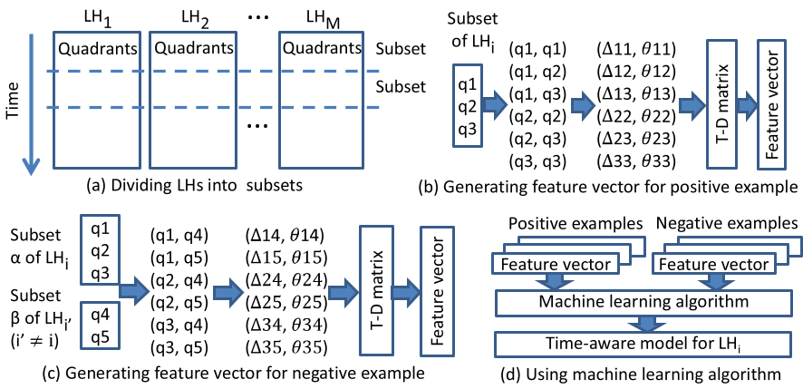 Fig 1: The learning process for the time-aware model, calculating time differences (Δt) and distances (Δd) to build a unique mobility fingerprint.
3. Dual-Sided Matching
The system creates models for both the account and the location history simultaneously, then fuses the scores. This "Dual" approach proved significantly more accurate than looking at just one side.
Experiments: How Deadly is This Attack?
The authors tested the method using real-world Wi-Fi probe data and Twitter accounts from 53 volunteers, then scaled the experiment by adding up to 100,000 "noise" accounts.
| Metrics | 53 vs 53 | 1 vs 10,000 (Noise) |
|---|---|---|
| Top-1 Success Rate | 75.1% | ~0% (due to noise density) |
| Top-100 Success Rate | 100% | 61.1% |
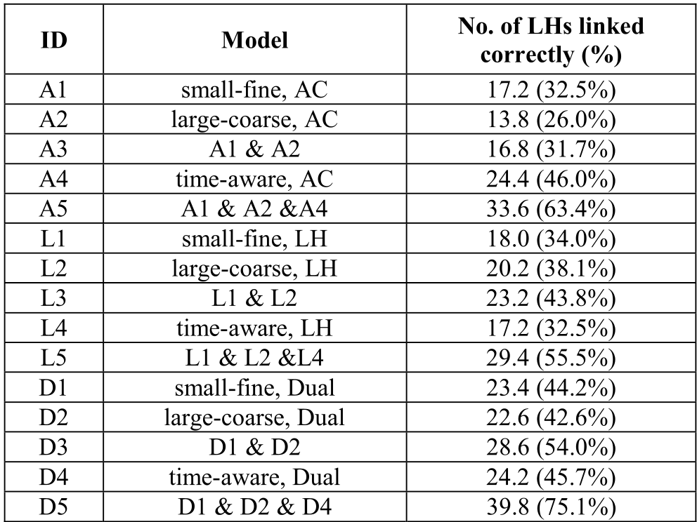 Fig 2: Comparison of different model combinations. Note how 'D5' (the combined Dual-Model) vastly outperforms the individual components.
Key Insights from Results:
- More models = More power: Using all six models (Dual Small-Fine, Large-Coarse, and Time-Aware) performed the best.
- The "Top 100" Threat: While identifying the exact person among 100,000 candidates is hard for an algorithm, narrowing a million people down to just 100 survivors allows a human "attacker" to finish the job manually with high ease.
- Resilience to Obfuscation: Even when the location history was reduced to just one week of data, the system could still identify targets with alarming accuracy.
Critical Analysis & Future Outlook
This research highlights a terrifying reality: Time is the ultimate de-anonymizer. Even if you hide your exact GPS coordinates, the speed and timing of your digital footprints link together like pieces of a puzzle.
Limitations:
- Language Nuance: Currently, the system uses a basic natural language analyzer to extract place names. It can be fooled by "I wish I were in Kyoto" (Type 3 noise).
- Computational Cost: Processing 100,000 accounts took several days on a high-end workstation. While practical for state actors or forensic investigators, it’s currently too slow for real-time web-scale attacks.
Takeaway for the Industry: To truly protect location privacy, one cannot simply add spatial noise. We must break the temporal correlation—perhaps by delaying data release or injecting "physically plausible" fake path segments into the history.
Conclusion
The "Time-aware multi-resolutional approach" represents a shift from graph-based de-anonymization to physics-based identification. It proves that our physical limitations—our inability to be in two places at once—is actually our most identifying feature.