
Beyond the Tag: Using Social Circles to Solve Geographical Ambiguity in Social Media
Toponym Resolution in Social Media
This paper presents a social-context-based approach to Toponym Resolution (geographical disambiguation) in social media, specifically Flickr. It utilizes an "expanding context" methodology that leverages relationships between users and their social networks to assign specific Where-On-Earth Identifiers (WOEIDs) to ambiguous location tags.
TL;DR
In the chaotic landscape of social media, a tag like "Cambridge" could mean the tech hub in the UK, the university town in Massachusetts, or even a brand of cigarettes. This paper demonstrates that we can solve this ambiguity not just by looking at what was posted, but by looking at who posted it and who they know. By shifting the focus from the "document context" to the "social context," the authors improved disambiguation accuracy (F-measure) from 83% to 89%.
Problem & Motivation: The Poverty of Local Context
Traditional Information Extraction (IE) thrives on rich grammatical structures. However, social media platforms like Flickr or Twitter (X) replace sentences with "bags of tags." This creates two major hurdles:
- Lexical Ambiguity: "Barry" is a town in Wales, but it's also a common first name.
- Contextual Sparsity: A single photo might only have one or two tags, providing zero clues for a classifier to work with.
The authors' key insight is that social media users are creatures of habit and community. A user who lives in Sheffield is likely to tag other photos with "South Yorkshire." Furthermore, their friends are likely to post about similar geographical areas.
Methodology: The Expanding Context
The researchers utilized Yahoo! GeoPlanet as their source of truth, treating it like a WordNet for the world. They structured the disambiguation as a multi-class classification problem, building a feature vector for each target location based on:
- Ancestors (Hypernyms: e.g., Sheffield is in South Yorkshire)
- Children (Hyponyms: Suburbs)
- Neighbors (Coordinate terms: Adjacent towns)
Note: The methodology expands the "Information Context" (IC) from the individual photo (D) to the User (U), then to the User's Contacts (C).
Measuring Ambiguity
Rather than just counting meanings, the authors used Shannon's Information Entropy () to measure how "uncertain" a term is. This allowed them to prove that as entropy (ambiguity) increases, the reliance on external context (social network) becomes more critical.
Experiments & Results: The "Social Radius" Limit
The team tested 20 target location names across three regions: Cambridge, Sheffield, and Cardiff. They used SVM classifiers to compare four context levels (D, U, C, CC).
Key Findings:
- The User Leap: Moving from Document-only (83.2%) to User-context (89.1%) was the single biggest performance gain.
- The Social Ceiling: Including direct contacts (C) gave a marginal boost, but going to "Contacts of Contacts" (CC) actually introduced noise, dropping performance back down.
- Precision vs. Recall: Proximate context (the photo itself) yields high precision for specific tags, but as you aim for higher recall (finding all occurrences), social context becomes the dominant factor.
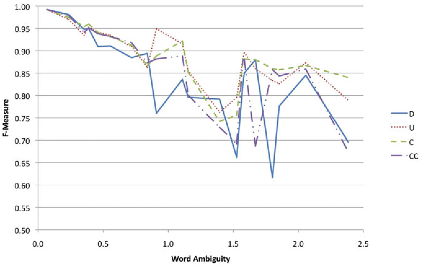 Fig 1: As term ambiguity increases, the performance of models using User (U) and Contact (C) context stays significantly higher and more stable than Document-only models.
Critical Analysis & Conclusion
The takeaway is clear: Location is a social construct. In the digital world, your geographical identity is defined by your network.
Takeaway
For developers building location-aware search engines or recommendation systems, the results suggest that we should weight a user’s historical "geographical footprint" more heavily than the immediate metadata of a single post.
Limitations & Future Work
- Data Source: The study is limited to Flickr. In faster-moving streams like Twitter, temporal context (time of post) might be as important as social context.
- The "30km" Rule: The paper uses a fixed 30km radius to define a "location match," which might be too broad for neighborhood-level tagging and too narrow for regional descriptions.
- The Next Frontier: Future research could replace simple frequency vectors with State Space Models or Graph Neural Networks to better model the "strength of ties" between users, rather than treating all contacts as equal.
Senior Editor's Note: This work serves as a foundational bridge between traditional GIS (Geographic Information Systems) and Social Graph analysis, proving that the identity of the "Who" is the best key to unlocking the "Where."