
Decoupling Urban Mobility: Advanced Travel Mode Detection via Random Forest and Socioeconomic Fusion
18824_Travel Mode Detection Using GPS Data and Socioeconomic Attributes Based on a Random Forest Classifier.
This paper presents a two-stage travel mode detection framework combining rule-based heuristics and a Random Forest (RF) classifier to identify six transportation modes (subway, walking, bicycle, e-bike, bus, car). By integrating GPS data with socioeconomic attributes, the model achieves a state-of-the-art overall accuracy of 93.11% on a large-scale dataset from Shanghai.
Executive Summary
Understanding how people move within a city is the cornerstone of modern urban planning and traffic management. While GPS data provides a digital breadcrumb trail, interpreting those crumbs into specific "modes" (Bus? Car? E-bike?) remains a challenge due to overlapping speed profiles and signal interruptions. This paper introduces a high-performance framework that combines rule-based heuristics for subway detection with a Random Forest (RF) classifier for surface modes. By integrating Socioeconomic Attributes into the feature set, the researchers achieved an impressive 93.11% accuracy, effectively solving the long-standing "Bus-Car Confusion" problem.
The "Confusion" Problem: Why GPS Isn't Enough
Earlier attempts at mode detection relied primarily on kinematic features: average speed, maximum velocity, and acceleration. However, these features often overlap:
- The Subway Paradox: Underground transit involves frequent signal loss, making traditional classification nearly impossible.
- The Bus-Car Overlay: In heavy urban traffic, a bus and a private car may exhibit identical speed profiles and stopping patterns.
- The E-Bike Grey Area: E-bikes sit in a kinematic middle ground between bicycles and motorized vehicles, leading to high misclassification rates.
Methodology: A Two-Stage Surgical Approach
Stage 1: Heuristic Subway Filtering
The authors recognize that subway trips are outliers due to signal loss. Instead of forcing these into a machine learning model, they use a Rule-Based Method. By matching the trip's origin and destination to known subway entrance/exit coordinates and checking for terminal proximity (Distance Thresholds ), they isolated subway trips with 98.09% accuracy.
Stage 2: Optimized Random Forest Classification
For the remaining five modes, the authors didn't just dump all 22 available GPS variables into the model. They performed a rigorous Feature Selection using Wrapper and Filter evaluators to identify the "Golden Seven" variables:
- Trip Distance (DIST)
- Mean Speed (SMEAN)
- 50/75/95 Percentile Speeds (S50, S75, S95)
- Average Orientation Change (OAVG)
- Skewness of Speed Distribution (SSKEW)
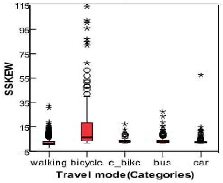 Fig 1. Pattern distribution of the selected variables showing how kinematic features distinguish modes like walking and cycling.
The Secret Sauce: Socioeconomic Integration
The ultimate breakthrough came from adding four non-GPS attributes:
- Ownership of bus cards.
- Number of household bicycles, e-bikes, and cars.
This provides the model with Inductive Bias. If a user doesn't own a car but has a bus card, the model is significantly more likely to correctly label a "confused" motorized segment as a Bus trip.
Experimental Results & SOTA Comparison
The Random Forest model was pitted against Artificial Neural Networks (ANN) and Support Vector Machines (SVM).
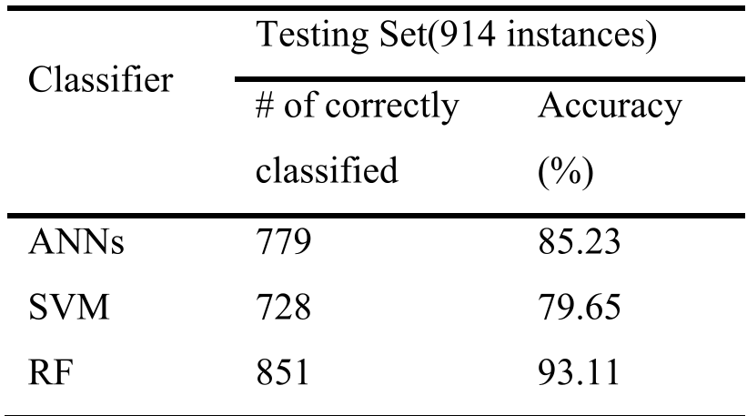 Table 1. The RF classifier significantly outperforms traditional benchmarks in accuracy.
The results showed that while GPS data alone achieved ~89% accuracy, the addition of socioeconomic data pushed performance to 93.11%. The precision for e-bikes jumped by 10%, and the number of bus trips misclassified as cars dropped by 30.
Critical Insight & Conclusion
The success of this work lies in its acknowledgment of Context. In the real world, travel choices are not just kinematic events but socio-economic ones. By combining the physical reality of the trip (GPS) with the economic reality of the traveller (Attributes), the authors have created a model that is both logically sound and statistically superior.
Takeaway for the Future: While GPS accuracy continues to improve, the "Last Mile" of classification accuracy will likely come from Cross-Domain Data Fusion—integrating GIS, personal attributes, and perhaps even real-time traffic data into the inference engine.