
Streamlining Chaos: An Integrated Twitter-Based System for Disaster Information Sharing
A Twitter-Based Disaster Information Sharing System
The paper presents a real-time, Twitter-based disaster information sharing system consisting of reporting and mapping functions. By integrating the previously separate DITS (Tweeting) and DIMS (Mapping) subsystems into a unified web application, the authors achieved a more user-friendly interface that automatically embeds geo-location, MGRS codes, and local disaster hashtags into tweets.
TL;DR
In the wake of disasters, every second spent navigating a complex UI is a second lost for rescue efforts. This research introduces a revamped, real-time disaster information system that bridges the gap between social media reach and geographic precision. By automating geotagging and hashtag generation within a unified mobile-friendly web app, the authors ensure that vital reports are both highly accurate and visible to the global Twitter community.
The "Data Silo" and "Geotag Gap" Problem
During catastrophes like the Great East Japan Earthquake or Hurricane Sandy, Twitter became a lifeline. However, two major technical hurdles persist:
- The Geotag Gap: Only about 0.42% of tweets are natively geotagged, and text-based locations are often ambiguous (e.g., which "Central Park"?).
- The Information Silo: Most disaster-specific apps (like FEMA's) keep data within their own ecosystem. If you don't have the app, you don't see the help request.
The authors recognized that their previous two-part system (DITS and DIMS) was still too cumbersome for users under stress, requiring multiple page transitions to switch from reporting a fire to finding a shelter.
Methodology: Automation Over Manual Input
The core philosophy of the proposed system is automated context. Instead of forcing a panicked user to type their address or find a hashtag, the system does the heavy lifting:
- Automated Metadata: The app fetches GPS data and converts it into a human-readable street address and a highly precise MGRS (Military Grid Reference System) code.
- Standardized Hashtags: It automatically appends
#[Municipality Name] disasterand#rescuetags, ensuring the information is indexed correctly for government agencies and local volunteers. - Unified UI: By merging reporting and viewing functions into a single menu, the system minimizes the "Time-to-Post."
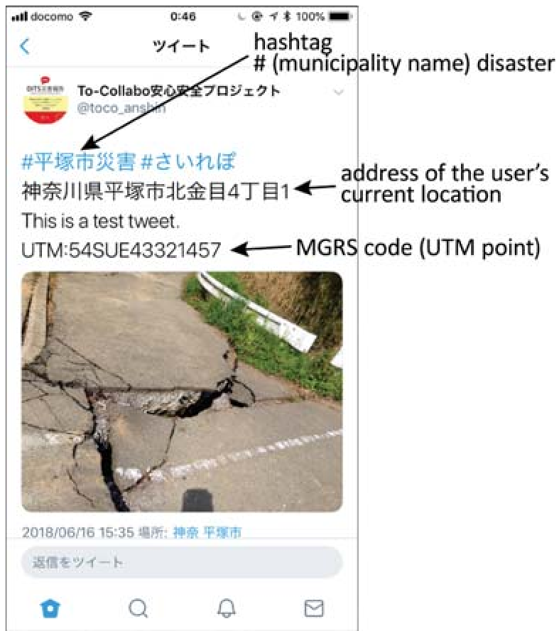 Figure 1: The simplified main menu allows users to toggle between reporting and viewing nearby hazards instantly.
Visualizing the Crisis in Real-Time
The mapping component provides an intuitive "Disaster Dashboard." Users can see pins representing nearby incidents within a 5km radius, with colors indicating the type of disaster (e.g., flood vs. earthquake).
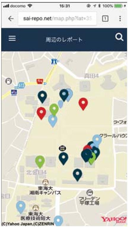 Figure 2: The mapping interface plots nearby reports, allowing victims to visualize safe zones and hazard areas.
Crucially, because the system posts directly to Twitter, the data isn't trapped. A rescue team doesn't need the authors' app to see the tweet; they just need a Twitter feed.
Critical Analysis & Future Outlook
While the system significantly lowers the barrier to entry for reporting, it faces two modern challenges:
- Platform Dependency: The system relies heavily on the Twitter API, which has undergone significant pricing and accessibility changes in recent years.
- Verification: In a real disaster, misinformation can spread as fast as facts. The authors suggest future work will include "automatic extraction of situational information" to help classify and verify the validity of tweets.
The Takeaway: The value of this work lies in its Human-Computer Interaction (HCI) focus. In emergencies, simplicity is not just a preference—it is a functional requirement. By automating the "metadata" of a disaster, this system turns a standard tweet into a professional-grade rescue signal.