
Towards a Unified Spatial Crowdsourcing Platform: The "MTurk" for the Physical World
Towards a Unified Spatial Crowdsourcing Platform
This paper serves as a vision piece proposing a Unified Spatial Crowdsourcing Platform designed to streamline diverse spatial tasks like ride-sharing and crowd-sensing. By introducing a holistic framework with "spatially-aware" modules, it moves beyond task-specific silos to create an industry standard similar to Amazon Mechanical Turk but optimized for geographical constraints.
TL;DR
Spatial tasks—from hitching a ride via Uber to geotagging photos—are currently trapped in fragmented, application-specific silos. This paper proposes a Unified Spatial Crowdsourcing Platform that abstracts the complexity of location-based task assignment, spatial indexing, and result aggregation into a single, scalable system architecture, effectively building a "Spatial Amazon Mechanical Turk."
The "Geography Gap" in Modern Computing
We live in an Era of the Crowd. Need a logo? Go to Upwork. Need an image labeled? Use Amazon Mechanical Turk (MTurk). However, these platforms fall apart when the task requires a physical presence. If you ask a random worker in London to rate a restaurant in Minneapolis, the result is worthless.
The problem is twofold:
- General platforms are spatially blind: They treat a worker's location as irrelevant metadata.
- Specialized platforms are fragmented: Uber, Lyft, and Instacart all had to build their own spatial indices, routing, and prediction engines from scratch. There is no shared infrastructure.
Methodology: The Architecture of Space
To bridge this gap, the authors identify the core components needed for a "Spatially-Aware" platform.
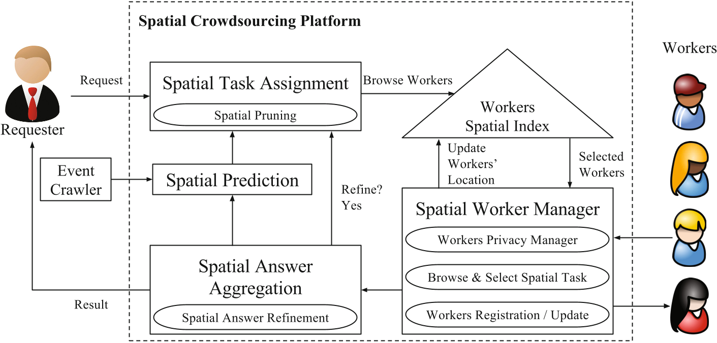
1. Spatial Worker Manager & Privacy
Unlike standard managers, this module tracks real-time movement while balancing the Privacy-Utility Tradeoff. It ensures workers can be found without exposing their exact trajectories to malicious actors.
2. Workers Spatial Index
Efficiency is key. To assign tasks in milliseconds, the platform utilizes advanced spatial data structures like R-trees, Quadtrees, or Grid indices. This allows the system to query "all available drivers within 2 miles" without scanning the entire global database.
3. Spatial Task Assignment & Pruning
This is where the intelligence lives. The system doesn't just look for "closest" workers; it uses Spatial Pruning.
- Insight: In ride-sharing, a driver 1 mile away heading away from the destination is less valuable than a driver 2 miles away heading toward it. The platform prunes the former to save computational resources.
4. Spatial Answer Aggregation
How do you trust a crowd? In spatial tasks, Proximity = Confidence. If two people identify a landmark, the one standing 10 meters away is mathematically weighted higher than the one 500 meters away.
5. Spatial Prediction
The platform isn't just reactive; it’s proactive. By ingesting streams of data (traffic, local events, weather), the platform can predict that a football game ending at 5 PM will trigger a spike in ride requests, pre-positioning workers before the demand even exists.
Proving the Vision: Versatility Across Domains
The paper validates this unified approach through three distinct scenarios:
- Moving Assets (Ride-Sharing): Combines proximity indexing with direction-based pruning.
- Stationary Tasks (Photography): Simplifies the pipeline to "Closest-k" worker selection.
- Knowledge-Based Tasks (Geotagging): Uses a multi-cycle refinement process where the "answer" of the first group of workers narrows the geographical search area for the second group.
Critical Insight & Conclusion
The true value of this paper isn't just in the algorithms—it’s in the standardization. By identifying that "Location-Awareness" is a service that can be decoupled from the application logic, the authors pave the way for a future where a developer can launch a new logistics startup by simply calling an API, rather than building a spatial database from the ground up.
Future Outlook: As we move toward a world of autonomous delivery robots and ubiquitous sensing, a unified spatial backbone will be the "Operating System" that coordinates the digital crowd in the physical world.