
The City as a Social Sensor: Transforming Urban Computing with LBSN Data
Urban Computing Leveraging Location-Based Social Network Data: A Survey
This survey explores the emerging field of Urban Computing by leveraging Location-Based Social Network (LBSN) data (e.g., Foursquare, Twitter, Instagram). It presents a comprehensive framework for multi-source data management and analytics to solve city-scale problems like traffic, pollution, and social inequality.
TL;DR
As more than half of the world's population moves into cities, traditional urban planning is struggling to keep up. This landmark survey by Silva et al. argues that our digital footprints on platforms like Foursquare, Instagram, and Twitter aren't just social noise—they are high-resolution sensors. By repurposing Location-Based Social Network (LBSN) data, researchers can now map cultural boundaries, predict traffic anomalies, and even sense the "smells" of a city in real-time.
Deep Dive into the Motivation: Beyond Physical Sensors
Historically, "Urban Computing" was synonymous with "Physical Infrastructure." We measured cities using loop detectors for traffic, GPS units for taxis, and stationary air quality monitors. While precise, these methods are expensive, static, and blind to human experience.
The authors' core insight is that LBSNs provide a "participatory sensor network." Unlike a GPS tracker that only tells you where a person is, a Foursquare check-in tells you the semantics: they are at a "dim sum restaurant" or a "jazz club." This adds a layer of social and cultural intention to raw mobility data.
Methodology: The Three-Layer Framework
The researchers propose a structured approach to turning social media clutter into urban intelligence:
- Management Layer: Strategies for ingesting massive, heterogeneous streams via APIs (Streaming vs. Request-based) and storing them using distributed systems like HDFS and Spark.
- Analytics Layer: This is where the "magic" happens. The paper details techniques like Latent Dirichlet Allocation (LDA) for discovering geographic "topics" and Network Theory to build "Place Networks" (where nodes are locations and edges are user transitions).
- Service Layer: Final applications ranging from "beautiful route" recommendation engines to disease surveillance.
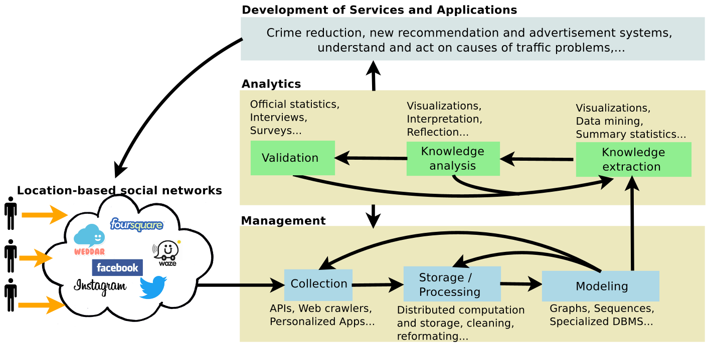 Figure 1: The standard framework for Urban Computing, highlighting the pipeline from raw LBSN data to final urban services.
Key Results: From "Smelly Maps" to Cultural Boundaries
The survey highlights several groundbreaking applications that prove the versatility of LBSN data:
- City Semantics: Using check-in patterns, researchers can ignore official city borders and discover "Livehoods"—regions that reflect the actual collective activity of citizens.
- Urban Smellscapes & Noise: By mining tags from Instagram and Flickr, researchers mapped where "nature" smells vs. "gas" smells, creating a "smell dictionary" for cities like London and Barcelona.
- Cultural Mapping: By analyzing food and drink habits on Foursquare, the authors were able to map cultural similarities across the globe, finding that digital behaviors often mirror deep-seated sociological theories (e.g., Huntington’s Clash of Civilizations).
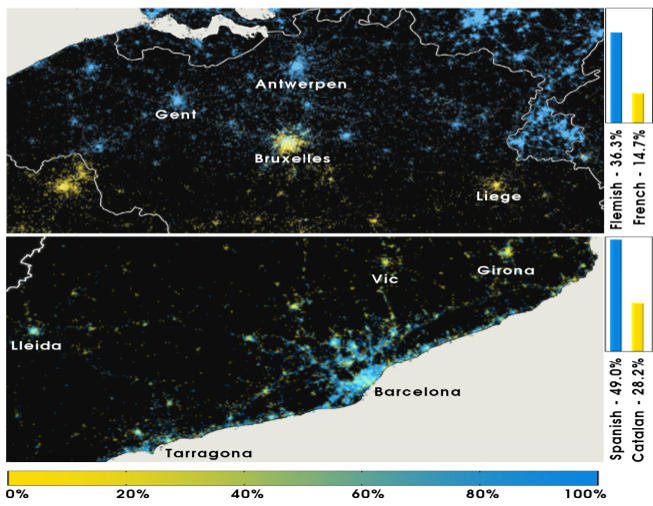 Figure 2: Mapping language adoption in Belgium and Spain using Twitter data, revealing linguistic and cultural frontiers.
Critical Analysis & The "Bias" Problem
Despite the optimism, the authors provide a sobering look at Data Bias. LBSN users are typically younger, wealthier, and more tech-savvy. This creates a "digital divide" where lower-income neighborhoods may appear as "dark zones" or "data deserts" on the map, leading to skewed urban policies if not handled with care.
Furthermore, the intentionality of social media means users "perform" for their friends. A check-in at a high-end gym might be shared, while a daily stop at a fast-food joint might be hidden, introducing a "social desirability bias" that physical sensors don't have.
Future Outlook: The Integrated City
The next frontier is Heterogeneous Integration. The survey points toward a future where we combine LBSN data with IoT sensors, satellite imagery, and government open data.
The Takeaway: Urban Computing is shifting from "sensing the hardware" to "sensing the people." For developers and researchers, the opportunity lies in building systems that don't just optimize for the shortest path, but the most culturally relevant or emotionally fulfilling one.
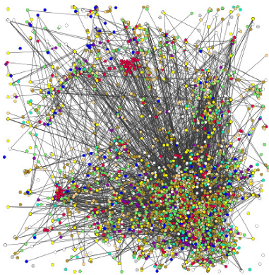 Figure 3: Betweenness centrality in place networks, used to identify critical "hubs" in city dynamics for business placement.