
IPBLOD: Leveraging Linked Open Data and Bayesian Networks to Solve Tokyo's Bicycle Crisis
Building Urban LOD for Solving Illegally Parked Bicycles in Tokyo
The paper introduces IPBLOD (Illegally Parked Bicycle Linked Open Data), a framework for sustainably building and augmenting urban Linked Open Data to address bicycle parking issues in Tokyo. By integrating SNS data with municipal statistics and using Bayesian Networks, the system infers missing data and visualizes urban problem distributions through a public Web application.
TL;DR
Researchers at the University of Electro-Communications have developed IPBLOD, a Linked Open Data framework that transforms "social sensor" data (Twitter/X) into a structured knowledge graph. By combining human observations with environmental factors—like weather and proximity to train stations—and applying Bayesian Networks, they can predict illegal parking density with 70.9% accuracy, providing a blueprint for data-driven urban intervention.
The "Social Sensor" Approach to Urban Friction
Tokyo faces a unique urban challenge: a massive surge in bicycle ownership has led to rampant illegal parking near railway stations, obstructing emergency vehicles and pedestrians. The problem isn't just a lack of space; it’s a data gap. Physical sensors are too expensive to deploy everywhere, and existing municipal data is trapped in "siloed" formats like CSV or PDF.
The authors argue that residents are "Social Sensors." However, social media data is often messy, lacking precise coordinates or context. The motivation behind this study was to create a pipeline that cleans this social noise, links it to official statistics, and fills in the blanks where humans aren't watching.
Methodology: From Ontology to Inference
The backbone of the project is a methodology that turns abstract urban problems into a strictly defined LOD Schema.
1. Schema Design (Activity-First Method)
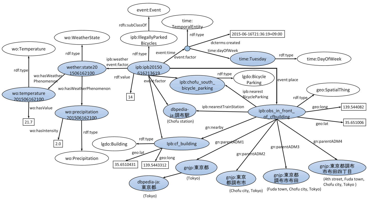
Instead of starting from scratch, the team extended the Event Ontology (EO). They treated each illegal parking instance as an "Event" with properties for:
- Place: Linked to LinkedGeoData and DBpedia.
- Factor: POIs (supermarkets, banks), Weather (JMA data), and population density.
- Value: The estimated or observed count of bicycles.
2. Bayesian Estimation for Missing Values
Because people don't tweet 24/7, the data is sparse. The researchers used Bayesian Networks to model the causal relationship between factors (e.g., "Is it raining?" "Is it a weekday?") and the likelihood of illegal parking.
- Complementation: They used the Jaccard coefficient to find similar observation points to fill in missing metadata (like parking fees).
- Refinement: By clustering 68 POI types into 46 super-classes via the LinkedGeoData ontology, they reduced noise and boosted prediction accuracy.
Experiments and Key Findings
The study analyzed 897 observation data points collected over a year. The results challenged common assumptions:
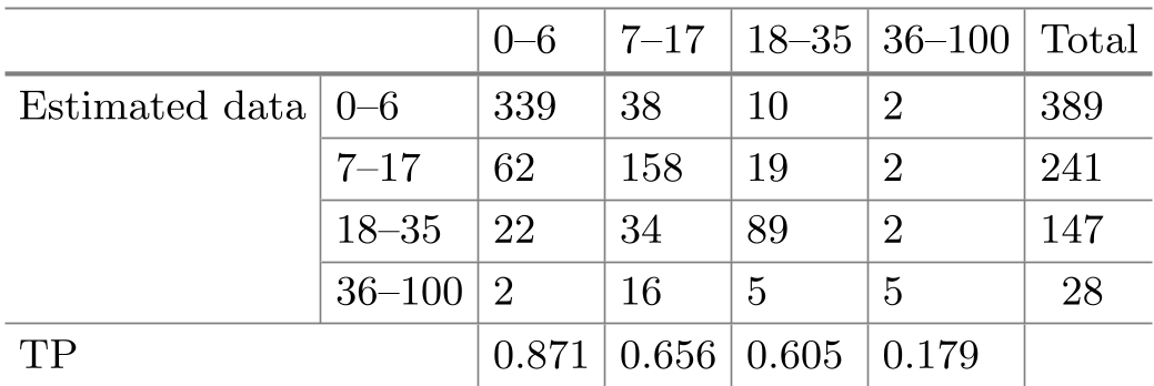
- Accuracy: The Bayesian model achieved 70.9% recall.
- Temporal Insights: While most assume illegal parking peaks during morning commutes, the LOD analysis revealed higher densities at night, likely due to commuters leaving bikes overnight or evening shopping activity.
- User Engagement: The publication of a visualization tool led to a significant increase in page views (from 187 to 705 monthly), suggesting that giving data back to the community encourages further data contribution.
Critical Insight & Conclusion
The true value of this research lies in its Semantic Interoperability. By converting social media posts into RDF triples (Linked Data), the researchers made it possible for a machine to understand why a bike is there—linking it to the nearest "Department Store" or "Rainy" weather.
Limitations: The model struggles with the "36-100" bicycle class due to data imbalance (fewer instances of massive parking clusters). Future work involves spatial estimation—predicting parking issues in areas where no one has tweeted yet.
IPBLOD proves that the solution to complex urban problems isn't always more hardware; sometimes, it's about building a better digital "connective tissue" between the data we already have.