
Urbanopoly: Gamifying the City into a Human-Powered Sensor Network
Urbanopoly -- A Social and Location-Based Game with a Purpose to Crowdsource Your Urban Data
This paper introduces Urbanopoly, a mobile "Game with a Purpose" (GWAP) that leverages Human Computation to crowdsource and validate urban data for OpenStreetMap. By wrapping data verification, correction, and collection tasks into a Monopoly-style social game, it achieves higher user engagement and data quality.
TL;DR
Urbanopoly is a social, location-based Android application that transforms urban data collection into a Monopoly-style game. By embedding data verification tasks into "mini-games," the researchers achieved a 3x increase in user engagement (Average Life Play) while cleaning and enriching OpenStreetMap data through human sensing.
Problem & Motivation: The Longevity Gap in Crowdsourcing
Open-source geospatial data projects like OpenStreetMap are invaluable but plagued by the "wiki-effect": data is often outdated, incomplete, or inconsistently formatted. While Human Computation—using human intelligence to solve tasks difficult for AI—offers a solution, most Games with a Purpose (GWAP) suffer from a "boredom barrier."
The authors' previous work, UrbanMatch, proved that users could link data quickly, but they didn't stay long. The core challenge addressed here is: How do we create a sustainable, long-term incentive for users to act as high-quality urban sensors?
Methodology: High-Stakes Property Management
The "secret sauce" of Urbanopoly is its storyboard. Instead of asking users to "check a tag," they are cast as landlords building a real estate empire based on their physical surroundings.
1. The Storyboard Architecture
Players use their current GPS location to see "venues" (shops, restaurants, monuments) on a map. These venues are actual OpenStreetMap entries.
- Acquisition: Users spend virtual currency to buy free venues.
- The Wheel of Fortune: When visiting a venue owned by another player, users spin a wheel. This "gamifies" the labor: to avoid fees or to earn money, users must complete a Human Computation task.
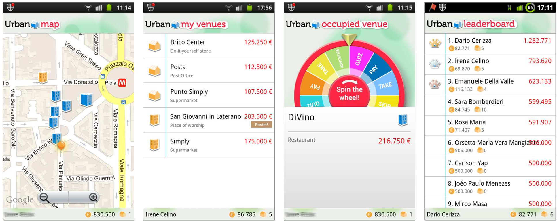 Figure 1: From left to right: Map view of local venues; User portfolio; The "Wheel of Fortune" trigger; Social Leaderboard.
2. Multi-Faceted Task Design
To prevent fatigue, the paper breaks data labor into three distinct mini-game types:
- Creative Challenges (Collection): Players "advertise" a venue by taking a photo or specifying attributes (e.g., "Is smoking allowed?").
- Quiz Challenges (Validation): Users answer multiple-choice questions to confirm if existing data is correct.
- Rating Questions (Ranking): Users rate posters/photos created by other players, acting as a secondary layer of quality control.
Human-to-Ontology Pipeline
The data collected isn't just stored as text; it is mapped to an OWL2 ontological model. For instance, a user defining a "Vegetarian" tag helps enrich the property ranges for the "Restaurant" concept in the underlying data structure.
To ensure honesty, the authors implemented Weighted Majority Voting. If a user provides information that later gets rejected by the community (via quizzes or ratings), they are penalized with "monetary losses" in the game, discouraging malicious contributions.
Experiments & Results: The 3x Retention Breakthrough
The experiment was conducted in the Milan and Lombardy region. The primary success metric was Average Life Play (ALP).
- Result: Urbanopoly achieved an ALP of 11 minutes, compared to just ~3.5 minutes for its predecessor.
- Throughput: By integrating with Facebook, the game leveraged social competition. Players fought for "Mayorships" and top spots on the leaderboard, which drove high-frequency data validation.
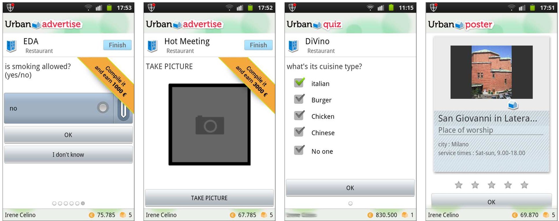 Figure 2: Examples of data collection (photos/forms) and validation (quizzes/ratings) tasks hidden within the gameplay.
Critical Analysis & Future Outlook
Urbanopoly represents a significant shift from "Task-Oriented" crowdsourcing to "Experience-Oriented" social sensing.
Strengths:
- High retention through social integration and a familiar Monopoly-style hook.
- A robust verification loop (contributor -> validator -> rater).
Limitations:
- Geographical Bias: The game relies on a density of venues; it may struggle in rural areas where "landlords" have nothing to buy.
- Battery/Data Overhead: Being a location-based mobile game with camera usage, it places high demands on mobile hardware.
Conclusion: Urbanopoly proves that urban sensing doesn't have to be a chore. By aligning the user’s desire for social status and entertainment with data curation needs, we can maintain "live" maps that evolve as quickly as the cities they represent.