
Personalized Obfuscate Region Maps: Solving the "Active Location Sharing" Privacy Trap
A User Sensitive Privacy-preserving Location Sharing System in Mobile Social Networks
The paper proposes a user-sensitive privacy-preserving system for active location sharing in mobile social networks. It introduces a separate "Obfuscate Server" that transforms public 3rd-party geographic data into personalized Obfuscate Region Maps using Hilbert Curves and semantic sensitivity profiles to prevent malicious tracking.
TL;DR
In the era of "active location update" apps like Foursquare or Tinder, sharing your precise coordinates is often a requirement, not an option. This paper introduces a system that doesn't just "blur" your location; it completely re-maps public geographic data into a personalized grid where sensitive areas are merged into anonymous regions based on your own privacy preferences.
Background: The Danger of Public Maps
Most location-based services (LBS) rely on public map data from providers like Google or Yahoo. The problem? Adversaries have access to the exact same data. If an attacker sees you are at a specific coordinate that corresponds to a "Cancer Treatment Center" on a public map, your privacy is compromised regardless of how many "dummy" locations the system generates.
The authors argue that existing solutions are either too computationally heavy for mobile batteries or too rigid in how they handle semantic information (e.g., distinguishing between being at a park vs. a bank).
Methodology: The Hilbert Curve Transformation
The core innovation is the Obfuscate Server. Instead of running privacy algorithms on your phone, a trusted server takes your "Sensitivity Profile" and performs a spatial transformation using the Hilbert Curve.
1. The Sensitivity Model
Users define a tuple: <FTs, V, T, Q_min>.
- FTs (Feature Types): Categories like Hospitals, Shops, or Schools.
- V (Sensitivity Value): A rating from [0, 1] for each category.
- T (Threshold): Your personal "panic button"—if a region's sensitivity exceeds this, it must be hidden.
2. The Hilbert Movement Algorithm
The algorithm scans the city grid. When it hits a cell with a sensitivity higher than the threshold, it doesn't stop; it follows the Hilbert Curve to merge adjacent cells into a single "Obfuscated Region" until the average sensitivity is diluted below the threshold.
 Figure 1: The proposed system architecture involving Social Networking (SNS), Location-Based (LBS), and Obfuscate Servers.
Experiments: Real-World Scenarios
Using data from Kumamoto City, Japan, the researchers tested the system with 50,000 simulated users.
- Customization: By changing the threshold from 0.3 to 0.25, the map automatically shifts, merging more cells into larger regions. This makes it impossible for an adversary to "learn" a user's patterns over time because the obfuscation map itself is dynamic.
- Density & Anonymity: In their "Revised Process," the number of regions was reduced to increase the probability that multiple users share the same "region coordinate," effectively providing -anonymity as a side effect.
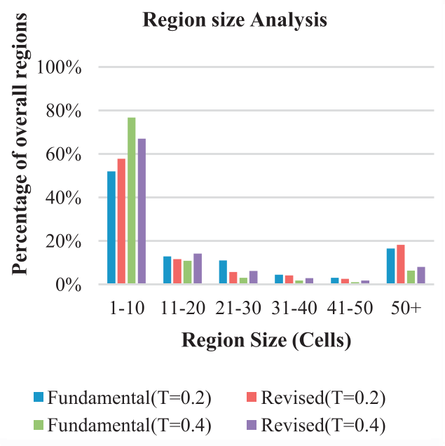 Figure 2: Comparison of different obfuscate region maps generated by varying user profiles and thresholds.
Critical Insight: Why This Matters
The shift from Passive to Active location sharing requires a shift from Global to Personalized privacy. This paper’s strength lies in its "User-Sensitive" approach—admitting that a hospital might be sensitive for one person but a mundane workplace for another.
Limitations:
- Trust: The system relies on a "trusted" Obfuscate Server. In a truly adversarial world, this server becomes a single point of failure.
- Utility vs. Privacy: As shown in their results, high privacy leads to larger "coordinate shifts," which might break the utility of apps that require high precision (e.g., finding the exact table someone is sitting at in a bar).
Conclusion
This work provides a robust framework for mobile social networks by moving the heavy lifting of privacy to a specialized server and using the Hilbert Curve to create a semantically aware mask. It proves that we can still enjoy the benefits of "nearby friends" features without handing over a high-resolution map of our private lives.